Sunday, December 28, 2025

Caonabo's Hidden Treasure

 Although hardly reliable, the anonymous author of Observations météorologiques et physiques sur St.-Domingue. Description du Rio-del-Oro, ou Rivière d'Or de Christophe Colomb. Découverte des mines d'or par cet amiral. Renseignemens sur les trésors du cacique Caonabo. Origine des peuples d'Amérique. Description de leur berceau. Ages des deux mondes. Numéro 6 reported traditions of Caonabo's hidden treasure. According to his informants, Caonabo's treasure was thrown into a river by his wife (Anacaona?) since she heard gold was the god of the Spanish. This tale seems similar to what was later reported of Hatuey's actions in Cuba, so the historical accuracy of this is up for debate. Certainly in the 1495 tribute lists, golden objects from Caonabo or his community were rendered to the Spanish. But tradition in the 18th century had it that Caonabo's hidden treasure consisted of 300 plaques of gold, a throne (probably a duho), a golden table (table with gold-encrusted parts?) and 52 charges of gold bars. As a paramount cacique believed to control some of the gold-producing parts of the island, this is actually somewhat plausible. Indeed, locals believed the treasure was still somewhere at the bottom of the river...

Thursday, December 18, 2025

More on Indigenous Caribbean Historical Matches

As we should have done at the beginning, we finally went back and re-read the reference study (Fernandes et al.) used by 23andMe for their indigenous Caribbean references. As expected, our Matches are to Ceramic Age samples from sites in Hispaniola (mostly eastern), Puerto Rico, and Bahamas. Our historical matches fell into the following major groups based on the above study's analysis of the genomes of ancient Antillean peoples:

Haiti Ceramic: 2 matches

Bahamas Ceramic: 2 Matches

SECoast DR Ceramic: 11 Matches

Eastern Greater Antilles Ceramic: 11 matches

The overwhelming number of matches (although mostly small) are with what the study terms Southeast Coast DR groups and Eastern Greater Antilles (which includes samples from Puerto Rico and the eastern Dominican Republic). This matching pattern is to be expected given the Ceramic Age population largely replacing Archaic lineages and the pattern of close relatives from different sites on Hispaniola or genetic matches between individuals from other islands. To what extent this pattern was also due to relatively small population sizes in Hispaniola and Puerto Rico is another mystery. We have always tended to prefer somewhat higher population numbers for Puerto Rico and Hispaniola in pre-Columbian times based on Moscoso's analysis of Puerto Rico. 

We also found it cool that some of our larger matches were to the two Individuals in the Haiti Ceramic clade. These two individuals were related and harbored significant Archaic ancestry from groups on the island before the Saladoid or Arawakan expansion to the Greater Antilles (unless we are already outdated in our terminology here). We matched the two ancient Haitians from Diale for approximately the same amount of total shared cM on 2 segments. It would be interesting if part of that shared ancestry was from the earlier, Archaic population.

Tuesday, December 16, 2025

Indigenous Historical Matches

One of the more interesting aspects of 23andme is seeing the historical matches. Since we have ancestry from Puerto Rico that includes indigenous Caribbean admixture, we found a very large number of matches with the Indigenous Caribbean Ceramic Age samples on 23andme. While most were undoubtedly very small matches, we found it fascinating to see matches from the Haiti, Dominican Republic, Puerto Rico and the Bahamas. Indeed, some of the matches were with individuals buried in the same area, like the two from northern Haiti's Fort-Liberté Bay. To make the feature even more interesting, 23andme should provide more precise information on the chromosome segment's location. It might be worthwhile to explore these matches to various indigenous Caribbean peoples who were related to others from different parts of Hispaniola or even different islands altogether. 


Despite the lack of these features, it was still interesting to note that most of our matches are with samples from Hispaniola (mainly the Dominican Republic). This is presumably due to the far greater number of indigenous Caribbean samples from the DR as well as the migration/intermarriage of indigenous peoples between Hispaniola and Puerto Rico (and the Lucayan Islands). Nonetheless, we found it intriguing that the highest matches were with samples from Hispaniola. The largest amount of shared ancestry was with an ancient woman from the site of Andrés, east of Santo Domingo. Although we only share 16.45 cM across 3 segments with this woman, this supposedly means we share more ancestry with her than 99.90% of all 23andme customers who share DNA with her. The next largest matches were of 10.8 and 10.2 cM with two individuals from Diale 1, a site in northeastern Haiti. Although only 2 segments, the amount of shared DNA with the two individuals is similar and possibly the same segment. If 23andme provided the segment information, I could potentially explore my relation to the 2 people from the Diale site in Haiti and the woman from Andrés. Even more intriguing is the fact that the two individuals from Diale had 16-20% Archaic ancestry from peoples who lived in the Antilles before the Arawakan-speakers migrated to the Greater Antilles. Moreover, the two people from Diale, who lived sometime between 800 CE to 1200 CE, may have fallen under the sphere of influence of Marien, a cacicazgo that was perceived by the Spanish sources as the most powerful chiefdom or polity in northern Haiti. Of course, there is no evidence for Marien in this earlier time period, but the site which was the probable capital of Marien was inhabited by the 1200s.


In addition, we shared 2 segments of DNA with two other individuals from the modern Dominican Republic. In the case of Ceramic Age Caribbean Individual I15112, from El Atajadizo, DR, we have more common DNA with her than 91.90% of all 23andme customers. For Ceramic Age Caribbean Individual I12350, we share more DNA with her than 87.90% of all 23andme customers who match her. The general picture then is one of closer matches with women from sites in the DR and Haiti and a plethora of smaller matches in Puerto Rico, Dominican Republic, and the Bahamas. Since the site where these individuals were found is no sure guarantee of their origin, it is difficult to say with any certainty where they may have originated from. Therefore, it is possible some of these matches were with indigenous people who may have hailed from Puerto Rico or the eastern Dominican Republic before migrating. Nonetheless, we believe that the two related individuals from Diale, Haiti may have come from the area and one was male while the other female. Overall, the closest indigenous matches were from Atajadizo, a site near San Pedro de Macorix, and the two relatives from Haiti. The results could be explained by a number of factors but are certainly consistent with a shared ancestry between indigenous peoples in Puerto Rico and Hispaniola. They could also be due to the forced relocation of indigenous peoples from Hispaniola and the Bahamas to Puerto Rico in the 16th century. But historians and archaeologists have provided more than enough evidence for long-standing contacts between the eastern part of Hispaniola and Puerto Rico. 

Wednesday, December 3, 2025

Cacicazgo of Guahaba

Aubourg's map showing the placement of a village in Guahaba at the site of Lacorne.

Although often overlooked in colonial accounts, Guahaba was a major Taíno cacicazgo in northwestern Hispaniola, whose political importance and population size have been underestimated due to Spanish violence, depopulation, and incomplete documentation. Known as the land from which Hatuey fled to Cuba to escape Spanish invasion, Guahaba was located in northwestern Haiti. The exact boundaries of the district and its political organization before Spanish conquest is difficult to discern. Tejera, drawing on Las Casas and the Spanish chroniclers, described Guahaba as 18 leagues from Cuba (271). Guahaba itself was said to be in a valley with a river called Hami flowing in it (205). Bernardo Vega, also drawing on similar sources and Peter Martyr d'Anghiera, saw Guahaba as likely located between Gros Morne and Borgne, possibly also the area of Guanacano in the map of Morales (30). Moreover, the region Las Casas referred to as Araguey, a valley and river, was where the Spanish founded the town of Lares de Guahaba (37). Like Vega, Valmé also saw Guahaba as being centered in the valley of Trois Rivieres (178). Keegan likewise focused on Trois Rivieres as the probable location near Port-de-Paix of a very large Taino settlement seen by Columbus's men in the First Voyage (58). While scholars disagree on the exact details, it is clear that Guahaba was in Haiti's northwest, and perhaps with its largest settlement near Gros Morne or Port de Paix. Who was its paramount cacique is unclear, although Hatuey is a likely contender since he was able to lead a large following to Cuba.  

Arranz Márquez's table for the caciques of Lares de Guahava (Guahaba).

Unfortunately, looking at the 1514 repartimiento records sheds little additional light on Guahaba. The area had the smallest Indian population, only 487, but this was likely the result of 3 factors: the exodus to Cuba led by Hatuey, population loss incurred during the "pacification" of the area ordered by Ovando and probably the forced relocation of indigenous peoples to distant locations where mining was conducted or more profitable.  Of the 10 caciques with followers assigned to encomenderos at Lares de Guahaba, some still had indigenous names: Bayacaguera, Mayagumaca, Mota, Miquero. But the one with the largest number of followers, Gaspar Mejias, could have been from the old Guahaba elite or possibly one whose ascent was tied to the changes introduced by the encomienda system (Arranz Marquez 571). Judging by the small indigenous population assigned to encomenderos, one can only safely speculate that the Spanish conquest, encomienda system, disease, and flight to Cuba significantly lowered its population by c. 1514.

The Morales map of Hispaniola showing the northwest.

Even the excellent map of Morales, a great source for understanding, to some extent, the indigenous geography of our island, is of limited utility for Guahaba. Some places in northwestern Haiti are listed by their Spanish names, although some of the rivers and bodies of water retain indigenous toponyms. For example, Guanacano, south of Lares de Guahaba.The river "Hany" also appears on the map, flowing near Lares de Guahaba. Other places listed are too hard to read clearly, but the place at Haiti's northwestern tip appears to read Yahaba. Is this Guahaba? This region is certainly closer to Cuba than where Lares de Guahaba was founded, perhaps closer to the 18 leagues from Cuba mentioned previously. If so, the name must have been applied to a much larger area, extending to the east to Marien, the cacicazgo of Guacanagari. Yet the location of Lares de Guahaba and its proximity to rivers means this area could have been the population center of Guahaba in precolonial times. 

A dog figure found at the site excavated by Barker, possibly a capital of Guahaba (Olsen, On the Trail of the Arawaks). Olsen likens the figure to the dog cemi, Opiyel-Guarobiran.

If one looks to archaeology, only one settlement that was likely in Guahaba has been closely studied. Located on the old Lacorne habitation in Haiti, this site was known as early as 1947. In fact, Michel Aubourg, author of Haiti prehistorique, wrote that this was the site of 1000 huts described by Columbus when he first visited Haiti (54). This site was located 3 km from Trois Rivieres, south of the Tortuga Channel, and bordered on the east by Trois Rivieres. To its south lay the Lacorne habitation (27). Aubourg also believed it was a fishing village or settlement. Fred Olsen, in On the Trail of the Arawaks summarized the research of Paul Barker at the site. Many female figures were found there (Cadet site), and he believed it was the settlement of 1000 houses mentioned by Columbus. Some perhaps implausible figures are also suggested: 5-15,000 residents (114). Again, Columbus's problematic figures came from someone who did not see the settlement in question. Further, it was in his interest to portray the New World as agriculturally rich and full of people to justify the expenses. Still, it does appear that the Cadet site surveyed by Barker was large. Valmé, presumably drawing from Barker's work, described the site as including 240 houses (181). If this is accurate, this was definitely a very large settlement, possibly one of the largest in the Antilles. 

A narcotic grinder in the form of a frog from Guahaba (Olsen, On the Trail of the Arawaks).

As for the Spanish chroniclers and Columbus, they too are not detailed for Guahaba. Columbus, whose journal described northwestern Haiti, mentioned a group of Spaniards he sent to a large village in a valley 4.5 leagues southeast of the coast. This village, allegedly possessing over 1000 houses, was identified by the editor of the Markham edition and translation as modern Gros Morne (108). The people of this village also had hair over their shoulders and a river ran through the center of the valley. This does sound like modern Gros Morne, but further inland than the site at Cadet mentioned by Barker, which raises a number of questions. If the larger populated center was further inland, this would likely have been closer to where the Spanish later founded Lares de Guahaba. Columbus's son, whose The Life of the Admiral is also available in translation, described the same settlement. According to his biography, Columbus sent 9 men to this large inland village about 4 leagues from the coast, where they saw a village of more than 1000 huts in a valley (76). The details match those of Columbus's account, although now it is a little closer to the coast. 

Votive offering figure in the shape of a turtle's head from the Cadet site in Guahaba (Olsen, On the Trail of the Arawaks).

Besides Columbus and his son, the only other sources are the standard cronista accounts of the pacification of the island after Ovando's destruction of Xaragua. Rodrigo Mexia Trillo was sent north of Xaragua where he presumably clashed with Hatuey and other caciques in northern Haiti, ultimately defeating them and establishing Lares de Guahaba. Hatuey fled to Cuba and later resisted that island's conquest when Diego Velazquez arrived in 1511. According to Las Casas, about 50 years earlier Haitians had migrated to Cuba. Oliver has suggested this connection between eastern Cuba and Haiti can be seen in Taino complexes at Pueblo Viejo, Bani, Maisi, and Bayamo (161). It is thus more likely that migrations and cultural influence between peoples of Cuba and Haiti extended much further back in time. This contact must have facilitated the ability of Hatuey to establish himself in Maisi with his followers from Haiti. But besides passing references to Guahaba or Guahava in the campaign of Rodrigo Mexia Trillo and mention of Hatuey's flight to Cuba, little else is known.

Dog-shaped amulets in conch found by Barker in Haiti (On the Trail of the Arawaks).

Of course, one could not end the tale of Guahaba without following up on Hatuey's political career in Cuba. Established in Maisi, the heroic struggle of Hatuey was repeated by Las Casas. Las Casas, who may have deviated from historical truth to assign to Hatuey a special areito in which the god of the Christians was condemned (gold) and his epic refusal to become a Christian before his execution, is the best known source on this. However, whether or not this areito occurred or if Hatuey truly refused to go to heaven because Christians would be there, is not the point. Hatuey's resistance, which only lasted about 3 months in a guerrilla-styled conflict according to Mira Caballos, failed. But in a letter possibly from 1509 (or closer to 1511), Hatuey was described as "señoreaba la media Cuba" (330). To what extent this was hyperbole is also unclear, but Hatuey may have risen to a position of much greater authority than Maisi, easternmost Cuba. Indeed, his authority may have been more than that of a war-chief as speculated by Loven (504). This could have been reinforced by longstanding ties between eastern Cuba and Haiti with earlier alliances between caciques of the two islands that are not recorded in the Spanish sources. This may have made Hatuey an attractive figure for Cubans to support, particularly if he was a higher-ranking cacique in Guahaba before his flight from Haiti.

The monument to Hatuey in Baracoa, Cuba (Wikipedia)

Lamentably, his leadership did not coalesce into a larger anti-Spanish front. Yet despite his death by 1512, Hatuey's anti-Spanish movement was carried on by Caguax, who had served under him. Ultimately, the fate of Hatuey's followers is revealed only by 1514, in a letter by Velazquez. In his letter, he alluded to the Indians of "Yacahuey" or "Yahatuey" working for the Spaniards on estancias  near the Toha river. Some were even "free Christians" tied to the church of San Salvador. Indians still living in the region in the second half of the 16th century possibly include descendants of Hatuey's people. Lopez de Velasco mentioned "indios" living in Baracoa, Santiago, and Baracoa in the 1570s. To what extent Hatuey was remembered or the links to Guahaba is unanswerable, though Hatuey later became a symbol of Cuban nationalism and anti-colonial struggle.

In conclusion, Guahaba remains yet important chiefdom in the indigenous past of Haiti. The early sources that describe northwestern Haiti are often vague or difficult to correlate with the limited archaeological evidence. It is possible that Hatuey, the legendary cacique from Guahaba, was a paramount chief of the area before fleeing to Cuba. One of the largest known settlements in Haiti was also likely in the territory of Guahaba, though it is impossible to say this was the capital of the province. Similarly hard to answer is the relationship of Guahaba to Marien, its eastern neighbor. If Spanish sources describing Guacanagari as a paramount chief are accurate, Guahaba may have fallen under Marien's sphere of influence. Nonetheless, a very large settlement within Guahaba, possibly a fishing settlement, suggests it was a densely populated area. Guahaba's location in northwestern Haiti also made it ideal for exchange with Cuba and the Bahamas. This factor likely explains why Hatuey was able to lead followers to Cuba and find support from indigenous people there. In the future, archaeologists should revisit the Manigat and Cadet sites studied by Barker. Additional surveys in northwestern Haiti may reveal other sizable settlements in this part of the island.

Bibliography

Aubourg, Michel. Haiti prehistorique : mémoire sur les cultures precolombiennes, Ciboney et Taino. Port-au-Prince: Editions Panorama, 1966.

Arranz Márquez, Luis. Repartimientos y encomiendas en la isla Española: El Repartimiento de Albuquerque de 1514. Madrid: Ediciones Fundación García Arévalo, 1991.

Columbus, Christopher, and Clement Robert Markham. The Journal of Christopher Columbus: (during His First Voyage, 1492-93), and Documents Relating to the Voyages of John Cabot and Gaspar Corte Real. New York: B. Franklin, 1970.

Deagan, Kathleen A. En Bas Saline: A Taíno Town Before and After Columbus. Gainesville, FL: University of Florida Press, 2023.

Keegan, William F., and Florida Museum of Natural History. Taíno Indian Myth and Practice: The Arrival of the Stranger King. Gainesville: University Press of Florida, 2007.

Mira Caballos, Esteban. El indio antillano: repartimiento, encomienda y esclavitud (1492-1542). 1. ed. Sevilla: Múñoz Moya Editor, 1997.

Oliver, José R. 2009. Caciques and Cemí Idols : The Web Spun by Taíno Rulers between Hispaniola and Puerto Rico. Tuscaloosa: University of Alabama Press.

Olsen, Fred. On the Trail of the Arawaks. Norman: University of Oklahoma Press, 1974.

Tejera, Emiliano, Emilio Tejera, and Pedro Henríquez Ureña. Palabras Indígenas De La Isla De Santo Domingo. Ciudad Trujillo: Editora del Caribe, 1951.

Valmé, Gilbert R. Atabey, Yacayequey, Caney, 6000 Ans D'aménagement Territorial Préhispanique Sur L'île D'Ayiti: Haïti/République Dominicaine : Une Approche Holistique Du Patrimoine Zux Antilles : Les Paysages Culturels. Pompano Beach, Florida: Educa Vision, 2012.

Vega, Bernardo. Los Cacicazgos de la Hispaniola. 3. ed. Santo Domingo: Fundación Cultural Dominicana, 1990.

Monday, December 1, 2025
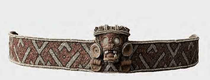
Anacaona's Gift

Anacaona's Gift: Cotton and the woven arts of the 11th to 17th century Caribbean by Joanna Ostapkowicz is a must-read for anyone interested in the material culture and history of the indigenous peoples of the Caribbean. Despite the paucity of extant materials made of cotton, the archival sources, Spanish chronicles, ethnographic analogies with South American peoples, and close analysis of ceramics and indigenous sculpture reveal often neglected aspects of Taino textile production and weaving traditions. Ostapkowicz presents compelling evidence for cotton production and weaving as one of great importance for the indigenous peoples economically, socially and politically and religiously. Cotton, as a source of material for wrapping cemis or for making hats, caps, naguas, masks, crowns, belts, capes, arm and leg bands, hammocks, burial shrouds, was undoubtedly a specialist activity for the most elaborate and best products. This made it an extension of cacical power or authority, particularly if the caciques controlled the storehouses where cotton was stored before redistributing it through their families, communities or other caciques. It is possible that elite women may have been the ones responsible for producing the best quality cotton goods, such as those using gold, shell, stone, feathers, and other products to produce refined cemis, belts, or elite regalia. Indeed, their elite status likely freed them from some of the other daily domestic duties of women who likely wove most of the cloth used by the indigenous societies of the island.

Much of the book analyzes closely each example or type of item made with or using cloth in so-called Taino and Kalinago cultures. This close analysis includes basketry, too, for additional examples of weaving use fiber materials. But the bulk of the analysis focuses on types of clothing and the application of cotton materials for wrapping or constructing materials like belts or cemi materials. The artistic and labor skills required to have produced some of the best examples must have been astonishing, which suggests there were specialized textile workers. Similarly, the production of the most elaborate stools (duhos) and platters or wooden objects similarly required experienced workers. Their close association with caciques, especially in the production of items and goods that, at their most refined level, were for elites, attests to a degree of power and hierarchy in the indigenous Caribbean chiefdoms more complex than many realize. Perhaps interpreting too literally Columbus and other chroniclers who often emphasized the nudity of the Taino, scholars have truly missed another dimension of the complex material culture. Indeed, some of these elaborate works featured thousands of beads, different weaving patterns, complex geometric patterns, and skillful use of gold or feathers. The arm bands, caps, skirts, and hammocks, sadly, have not survived, but the level of skill required to produce them (and in quantity) are a testament to the relatively high level of production. 

An area not fully explored however, and this is due to our limited sources in terms of surviving artifacts, is the extent to which the entire population of the cacicazgo had access to certain goods, like hammocks. Moscoso, for example, seemed to think hammocks were not universally used by all Taino. Similarly, the shortages of hammocks and the importation of cloth from Europe (not enough in the early colonial period, but a source for hammocks for settlers who took to the hammock) deserves further inquiry. To what extent were indigenous weavers in Jamaica learning to make European-styled clothes? Was there an increase in the scale of production for the "market" during European colonial rule, despite the lack of interest by Spaniards for cotton plantations in places like Hispaniola? What about Xaragua, when its tribute to Columbus was in cotton and included extra cotton treasures give by Anacaona? In other words, what were the mechanisms for the increase in textile production before colonialism? Was Xaragua, already noted for its cotton, producing a surplus for trade with other parts of Hispaniola, Cuba, and Jamaica? And to what extent were Taino products possibly exported south to the Lesser Antilles or the South American mainland for items like guanin? 

Tuesday, November 25, 2025

Acosta and the Incas

Reading Jose de Acosta's Natural and Moral History of the Indies for a deep chronicle of the Inca Empire is bound to disappoint. Acosta's work, which focuses on the Americas in general (though Acosta had traveled to other parts of the Americas like Santo Domingo), largely synthesized older accounts of the Inca past, particularly the works of Polo de Ondegardo. Consequently, his account of the Inca past is rather derivative and, besides references to the flora, fauna, and superstitions of Indians in Peru, adds little. In some respects his coverage of the Inca and Aztec Empires emphasizes how these peoples, deceived by Satan from Acosta's Jesuit perspective, built impressive civilizations that paved the way for Christianity to spread. Thus, unlike the indigenous peoples of Brazil or other parts of the Americas which lacked large kingdoms or polities, the Incas and Aztecs promoted religious cults that, like ancient Rome, facilitated the spread of Christianity through the state's institutions and influence across a vast territory. Acosta's perspective also reminded us of Edward Blyden's views on Islam in West Africa, which he similarly praised while also expressing the belief that Islam will prepare the path for the Christianization of black Africans. But to return to Acosta as a chronicler of the Incas, this does not offer much. Acosta shifts between condemnation of the Incas and admiration, and there are interesting moments of comparative ethnology of the various peoples of the America (and East Asia). But we hope to read another cronista with a more substantial narrative of the Inca past. And really, 1000 people sacrificed to accompany the dead Huayna Capac?

Saturday, November 22, 2025

Matu the Manatee

One of the more miraculous stories of the wondrous fauna in the New World was reported by the early Spanish chroniclers. According to their telling, a cacique in what is today Haiti, named Caramatextius, had a pet manatee. Named Matu, meaning generous or noble, it was caught while young and raised in a lake called Guarabo. After 25 years, however, a hurricane caused the Artibonite to flood, eventually driving Matu into the sea. While this story has unrealistic elements (a manatee who allegedly carried 10 men on its back and hated Christians because one of them attacked him), it was apparently renowned across the island. It is also interesting since manatee meat was one of the highly desirous sources of protein for the Taino. Further confirmation of the location of Caramatexius's manatee can be seen in the map of the island by Morales

Thursday, November 20, 2025

Catalina de Habacoa


Whilst perusing Arranz Marquez's Repartimientos y encomiendas en la Isla Española: El repartimiento de Albuquerque de 1514, we saw yet another cacique from the western part of the island whose community was forced to serve encomenderos in what is now the Dominican Republic. According to Peter Martyr d'Anghiera, Habacoa was a district or canton in Guacayarima (the southwestern part of Haiti). Thus, the cacique, Catalina de Habacoa, whose 44 Indians were forced to work to 2 Spaniards in Higuey, likely had to travel from one end of the island to another. This obviously meant that many indigenous peoples were forcibly relocated from the area they called home before 1492, and this likely contributed to the high mortality rates of the native population as they resisted, succumbed to hunger, or experienced disease and horrendous working conditions. 

Sunday, November 16, 2025

The Cacicazgo of Marien and Guacanagari

Map of Chican site clusters from Deagan's En Bas Saline: A Taíno Town Before and After Columbus

One aspect of Hispaniola's indigenous history that has been debated recently is the status of Guacanagaric as a paramount chief. Since it is possible that Columbus and the early European colonists misunderstood the nuances of indigenous political systems and possible changes in power relations, some have argued that Guacanagaric was possibly a subordinate or lesser cacique whose importance was exaggerated by Spanish accounts and his early alliance with Columbus. A problem with this narrative, however, is the power of Guacanagaric and the Marien chiefdom can be evaluated based on archaeological and historical evidence. While much remains to be done in terms of understanding the indigenous settlements and political arrangements in northern Haiti before 1492, the fact that Guacanagaric's probable capital, En Bas Saline, had one of the largest known plazas on the island of Hispaniola is significant. Evidence of public, monumental architecture and early Spanish sources suggest that Guacanagaric probably was one of, if not the most powerful, cacique on the northern coast of the island from at least Guarico (Cap-Haitien) to Monte Cristi, including parts of the northern plains and sierras to the south. 

Deagan's map of En Bas Saline in relation to the north coast

First, let's begin with the written sources. Columbus, whose Journal of the First Voyage in Journal of Christopher Columbus, is one of our earliest texts, saw Guacanagaric as a "youth" who was carried on a litter and accompanied by 200 men (117). In addition, Columbus later met 5 kings (caciques) subject to Guacanagari (141). This precious testimony suggests that Guacanagari was possibly a young, new ruler in 1492. Yet, despite his youthful appearance, he had at least 5 lesser caciques serving him. Or, at least that's what Columbus believed. Besides Columbus, the chronicler Oviedo also wrote of Guacanagari and Marien. According to Oviedo, a relative of Guacanagari accompanied Columbus on the return to Spain, where he was baptized and took the name of the Spanish monarch (30). This supports the idea of Guacanagari being recognized by the Spanish as a powerful king or Lord. Oviedo similarly wrote of Guacanagari's alleged sexual improprieties with his many women (133). Well, according to Jose Oliver, the cacique had 20 wives at one point (157). While still fewer than Behechio of Xaragua, some of these wives were likely part of matrimonial alliances with other caciques or lesser caciques. Accumulating so many wives was likely part of a strategy pursued by caciques to enhance their position on the island through alliances with different communities. Indeed, stealing or killing the wife of another cacique was of great significance. For example, Columbus's son wrote that Behechio of Xaragua, for instance, was said to have murdered a wife of Guacanagaric while Caonabo stole another. This would have disrupted alliances and family networks that affected how subordinate caciques or nitainos viewed their relationship with Guacanagaric. 

 guaíza from En Bas Saline. Guacanagari gifted elaborate types of these to Columbus. 

Columbus and the early Spanish sources  provide a wealth of details, despite their obvious limitations and bias. For instance, these sources provide an idea of things that were considered valuable in Marien. Cotton, for instance, was common at Guacanagari's village (Columbus 128). Elsewhere, a relation of tribute received from Indians in 1495, lists gold and an elaborate belt with 4 sheets of gold given by Guacanagari (Relación del oro y joyas que recibió el Almirante después que el receptor Sebastián de Olaño partió de la isla Española para Castilla, desde 10 de Marzo de 1495"). Thus, even without control of gold mining areas, Guacanagari's chiefdom still had access to fine and elaborate gold objects, belts, and even a frog-shaped grain of gold. Villages or settlements in the region could also be rather large. Guarico, nearby, may have held over 2000 people (Columbus 130). Furthermore, the land of Guarionex was said to be located 4 days to the east. This suggests that, roughly, Las Casas, writing in Apologética historia sumaria, may have been broadly correct when he wrote that Marien covered the northern coast after Guahaba to Vega Real, including parts of the Vega Real and the sierras. It was then followed by Macorix de abajo, which included Monte Cristi. Overall, Marien covered 15 leagues or more, and likely even more territory when the hills were included. Elsewhere, in "A Short Account of the Destruction of the Indies, Las Casas claimed to have personally met several high-ranking vassals of Guacanagari (20). This is further, albeit late and problematic, testimony of Guacanagari likely possessing paramount chieftain status in the North. 

Gilbert R. Valmé's aerial view of En Bas Saline and the larger Plaine du Nord region

Perhaps the most detailed yet problematic source of all is an account of Guacanagari's capital described by Luis Joseph Peguero. A writer from the Spanish colony, he may have had access to lost sources, including an account by Rodrigo Escobedo and Juan Salsedo. These two allegedly went to Guacanagari's court. One pueblo in the chiefdom, Cacuma, allegedly held 300 houses. The capital of Marien, likely today's En Bas Saline, was said to have 8000 houses of straw and wood. There were allegedly 4 streets, 4 barrios or sections, and a plaza in the center with the "palace" of the king in the midway point of the plaza (Peguero 38). It is very likely that the estimate of 8000 houses is a gross exaggeration, although Escobedo and Salsedo may have meant the larger district and not just the main settlement. Besides this estimate of 8000 houses, the capital's plaza contained a large house on its Southside where 100 soldiers and officials were (39). This may be an allusion to important elders and soldiers (nitainos) who assisted Guacanagari in the administration of the chiefdom. Later, the cacique was said to have had 25 nobles in his personal guard and a court with 8 elders (40). If he was relatively young in 1492, these elders may have been advisors who offered wisdom and practical experience in government. The Spaniards allegedly saw the temple of Marien, too. Supposedly square-shaped, made of wood and containing idols (including those fabricated with gold), the temple may have been a caney or similar structures used for various ceremonies (41). The idea of a highly ranked or stratified society also emerges in the description of the temple as having 4 separate entrances/exits for the different classes: royal family, nobles, plebeians and one only entered by the dead (used for funerary rites or rituals?). Guacanagari's palace was allegedly 32 paths long, 10 wide and divided into 4 parts. His palace included a nearby section used by 40 or more Indian women who cooked or prepared food (42). Later on, Peguero wrote of Guacanagari sending 800 archers to fight for the Spanish (73). While Peguero also blamed Roldan's rebels for burning Guacanagari's Pueblo and killing him for failing to pay tribute, other sources suggest Guacanagari died alone, in the mountains, after earning the hatred of his people and the betrayal of his Spanish allies (Nau's version of events). 


Although there are obviously many questionable aspects of what Peguero wrote about Marien's capital, Deagan's work at the site of En Bas Saline partly affirms it. Settlement at En Bas Saline by people who made Chicoid pottery began about 250 years before the arrival of Columbus. It may have been a Chican intrusion into a part of northern Hispaniola occupied by Meillacoid pottery makers (36). In addition, En Bas Saline was the only known ceremonial plaza site on the coast (39). Its larger region may have stretched from the west side of Fort Liberte bay to the west side of the Bay of Acul (40). The site of En Bas Saline also covered 90,000 square meters and features public architecture (56). The central plaza covered around 50,000 square meters and featured 3 mounded areas (73). The elite mound site in the plaza was apparently 34 meters by 16 meters (98). The earliest definable building on the central mound was circular or elliptical in shape with a diameter of 12 meters (114). Using Curet's ratio of floor space-per-person, Deagan has estimated the central mound building may have housed 20-30 people (123). This could have been the 'palace' of Guacanagari described by Escobedo. In addition, the evidence for public feasting at the pits shows the communal nature of the space (129). However, Deagan did not see probable evidence for surplus storage distribution by the cacique for these feats (138). Nonetheless, she found evidence for control or organization of labor and the means of craft production at the elite mound in the plaza (232). This indicates that the cacique did exert some control over the means of production (at least for some goods). Further evidence of at least some degree of social stratification or "ranked" societies can be seen in the fact that the scarcest animals, iguanas, sea turtles, and manatees, were only found in the central mound residence and burial pit (270). This would match descriptions in the Spanish chronicles of caciques monopolizing certain types of meat and food (such as a finer quality of casabe). 

Ultimately, Deagan views En Bas Saline as a "corporate chiefdom model." This may very well be true, but it seems probable that Guacanagari was not a lesser or subordinate cacique. Indeed, there was a string of villages on Haiti's North coast which were connected by an aboriginal road that ran from En Bas Saline to the modern-day Dominican republic (Keegan, 72). It is likely that Guacanagari's Marien was the most powerful chiefdom in the region and exerted influence on most of (if not all) of Haiti's northern coast. Furthermore, the cacicazgo may have been engaged in trade with Lucayans from Turks and Caicos. Keegan, who identified a prominent site (MC-6) on Middle Caicos, has found imported Chicoid pottery and speculates that the settlement likely engaged in trade with the northern coast of Hispaniola. Indeed, Keegan has even proposed that Caonabo, said to be of Lucayan origin, was from MC-6 (Keegan, 148). If so, then it is possible that Caonabo may have known of Guacanagari's chiefdom before Guacanagari became its ruler. Moreover, Marien may have been able to control trade between Hispaniola and Turks & Caicos along Haiti's northern coast.

The evidence, despite its limitations, suggest Marien truly was the seat of a paramount cacicazgo. To what extent Guahaba was fully in its sphere of influence is uncertain, but population numbers from the 1514 Repartimiento for Lares de la Guahaba and Puerto Real are suggestive of a much greater population in the area of Puerto Real (built near En Bas Saline). The population of Guahaba, whose center may have been at Gros-Morne, could have been autonomous but gradually fell under the influence of Guacanagari as he tried to use his alliance with the Spanish to increase his status. Las Casas, who at least met several of the subordinates of Guacanagari, believed it covered at least 15 leagues of territory and Moreau de Saint-Mery extended its southern border to the Artibonite. The latter even included Port-de-Paix in Marien and posited that Guacanagari commanded as many as 200,000 people! Moreover, by c.1514, there were still hundreds of Indians assigned in encomiendas far away from Puerto Real, about 317 indigenous people, whose caciques were from Marien. They might represent the core of the Marien cacicazgo's population, decimated by colonial conquest and forced relocation. One can imagine that their population in 1492 was significantly larger, and Guacanagari's chiefdom may have extended its influence across much more of northern Haiti.

Bibliography

Casas, Bartolomé de las, and Edmundo O'Gorman. Apologética Historia Sumaria. [3. ed.]. México, 1967

Casas, Bartolomé de las, and Nigel Griffin. A Short Account of the Destruction of the Indies. London, England ; New York, N.Y.: Penguin Books, 1992.

Columbus, Christopher, and Clement Robert Markham. The Journal of Christopher Columbus: (during His First Voyage, 1492-93), and Documents Relating to the Voyages of John Cabot and Gaspar Corte Real. New York: B. Franklin, 1970.

Deagan, Kathleen A. En Bas Saline: A Taíno Town Before and After Columbus. Gainesville, FL: University of Florida Press, 2023.

Fernández de Oviedo y Valdés, G., Amador de los Ríos, J., & R. Academia de la historia, M. (1851). Historia general y natural de las Indias, islas y tierrafirme del mar océano. Impr. de la Real academia de la historia.

Keegan, William F., and Florida Museum of Natural History. Taíno Indian Myth and Practice: The Arrival of the Stranger King. Gainesville: University Press of Florida, 2007.

Moreau de Saint-Méry, M. L. E. Description Topographique, Physique, Civile, Politique Et Historique De La Partie Française De L'isle Saint-Domingue: Avec Des Observations Générales Sur Sa Population, Sur Le Caractère & Les Moeurs De Ses Divers Habitans, Sur Son Climat, Sa Culture, Ses Productions, Son Administration, &c. &c. : Accompagnées Des Détails Les Plus Propres à Faire Connaître L'état De Cette Colonie à L'époque Du 18 Octobre 1789 : Et D'une Nouvelle Carte De La Totalité De L'isle. A Philadelphie: Et s'y trouve chez l'auteur ..., 1797.

Nau, Émile. Histoire Des Caciques D'Haiti. Port-au-Prince: T. Bouchereau, imprimeur-editeur, rue Courbe, 1855.

Oliver, José R. 2009. Caciques and Cemí Idols : The Web Spun by Taíno Rulers between Hispaniola and Puerto Rico. Tuscaloosa: University of Alabama Press.

Peguero, Luis Joseph, Antonio de Herrera y Tordesillas, Biblioteca Nacional, and Publicaciones del Museo de las Casas Reales. Historia De La Conquista, De La Isla Española De Santo Domingo Trasumptada El Año De 1762: Traducida De La Historia General De Las Indias Escrita Por Antonio De Herrera Coronista Mayor De Su Magestad, Y De Las Indias, Y De Castilla, Y De Otros Autores Que Han Escrito Sobre El Particular. Santo Domingo: [Museo de las Casas Reales], 1975.

Stone, Erin W. "The Conquest of Española as a “Structure of Conjuncture”. Ethnohistory 1 July 2021; 68 (3): 363–383. doi: https://doi.org/10.1215/00141801-8940494

Valmé, Gilbert R. Atabey, Yacayequey, Caney, 6000 Ans D'aménagement Territorial Préhispanique Sur L'île D'Ayiti: Haïti/République Dominicaine : Une Approche Holistique Du Patrimoine Zux Antilles : Les Paysages Culturels. Pompano Beach, Florida: Educa Vision, 2012.

Tuesday, November 11, 2025

The Afterlife of Marien


Whilst perusing the very helpful tables of Arranz Marquez in Repartimientos y encomiendas en la Isla Española: el repartimiento de Albuquerque de 1514, we came across 5 caciques with "del Marien" in their names. None of them were linked to encomenderos in Puerto Real, the Spanish colonial city founded near the likely site of Marien's capital. Thus, within about 22 years of first meeting Columbus, the population of Marien was severely displaced and likely experienced high amounts of death through disease, forced relocation, disrupted food supply, and forced labor. Guacanagari's people were now spread around in La Concepcion and Bonao. In the latter town, a surprisingly high number of Indians tied to the Marien caciques Torres del Marien (170 indios) and Velazquez del Marien (70) were laboring for Juan de Ampies. In La Concepcion, 3 caciques from Marien were listed: Antonio Escobar del Marien, Barahona del Marien and Cristobal del Marien. The indios linked to them numbered 117. This suggests that by 1514, Marien (presumably its "core" had about 317 indigenous people who had been relocated through the encomienda system. Over half of this group ended up in Bonao. In Puerto Real itself, where it is probably safe to assume much of the indigenous population was from the old cacicazgo of Marien due to the absence of gold mining, it is difficult to trace where the caciques and their communities came from. 

In one case, that of Francisquillo de Bayaha, we can presume he was from the area of modern-day Fort Liberte. The cacique called Mayordomo de Hatiel may have come from a region that appears in the Morales map to be south of the Artibonite and east of its mouth. This area may not have been part of the Marien cacicazgo. According to Bernardo Vega, it likely covered the territory from Borgne to Monte Cristi.It is unlikely for the area south of the Artibonite to have been part of Guacanagari's spheres of influence. In the case of Diego Aynaguana, however, it is somewhat ambiguous. The cacique Diego Aynaguana in Azua may have been relocated there via the encomienda system. Once again, the Morales map provides a clue since it appears to identify a river called Aynagua northeast of Puerto Real. If so, that means at least 349 Indians were forced to relocate from the environs of Marien. 

And of the caciques in Puerto Plata and other regions, a few may have been linked to the period of Guacanagari's rule in the 1490s. One cacique from Marien went by the name Cristobal. Was this possibly in reference to Columbus? Another cacique, Juan de Manuy, was assigned to an encomendero married to a native woman, Gonzalo de Arevalo. We were unable to find out when he came to the island, but if his wife was from this part of the island, he may have used her kinship ties and connections that may have preceded 1492 and the calamities of the colonial conquest. Furthermore, the one cacique assigned to a Puerto Real encomendero with more than 100 Indians was a man named Fernando Guanabax. We know from Peguero and Oviedo that a relative of Guacanagari traveled to Spain with Columbus on his first voyage. He was baptized there and took the name Fernando de Aragon. Is there any chance Fernando Guanabax was the same man? We admit this is pure speculation and quite unlikely, but he was the only cacique with more than 100 followers in the Puerto Real area.

As for the area around Lares de Guahaba and Haiti's northwest, we are unsure. Las Casas seemed to exclude Guahaba and Amaguey (near modern Gros Morne?) from Guacanagari's Marien. Charlevoix, writing in the 18th century, believed Marien covered all of the north coast from Cap St. Nicolas (Mole St. Nicolas) to Monte Cristi, as well as a part of the northern Vegal Real. Moreau de Saint-Mery echoed that sentiment, including Port de Paix as once in the domain of Guacanagari. Indeed, he even believed the Artibonite was the southern border for Marien, implying Guahaba would have fallen under Guacanagari's control or influence. In the next century, Haitian historian Emile Nau also wrote of Marien including Guahaba and the western limits of the Artibonite (Nau, 36). Perhaps even more boldly, the Haitian author Gilbert Valme added Tortuga to Guacanagari's territor (Valme, 229). Interestingly, the remaining indigenes of Tortuga were assigned to an encomendero based at Puerto Plata in c.1514. In terms of other modern scholars, Deagan, the archaeologist who has presented the best case for identifying En Bas Saline as Guacanagari's capital, similarly included Guahaba in his land (Deagan, 240). 

Until scholars uncover new sources, the mystery of Marien's end will continue. Scholars have different theories on the death of Guacanagari, for example. It would appear that he was likely dead within 10 years after meeting Columbus. And while his capital was likely occupied until the 1520s, it too was eventually abandoned. With about 317 Indians from Marien serving encomienda holders on the other side of the island in 1514, one can imagine high mortality rates and labor exploitation wiped out much of the remaining population. Even Puerto Real itself was later disbanded. But if 317 Indians from Marien were enumerated in 1514, scholars might be able to reach more accurate population estimates of the region's population in 1492. To what extent Guacanagari was able to control other provinces is up for debate, but the large plaza and public architecture at his capital suggest he was not such a minor or subordinate cacique after all. Indeed, Las Casas personally claimed to have met several of Guacanagari's vassals who were of high standing, presumably meaning caciques and nitainos who occupied more than the region near En Bas Saline. 

Friday, November 7, 2025

Caonao (Cahonao)

A section of northern Haiti/Dominican Republic depicting the likely site of Caonao, where the mountain of Cauta supposedly included the caves of Cacibajagua and Amayauna, in the famous map of Morales.

Whilst revisiting various sources on the indigenous polities or societies of the island, we came across some inconsistencies in Bernardo Vega's otherwise great Los cacicazgos de la Hispaniola. At one point he tries to concoct a theory that the island of Cayemite may have been the site where, according to indigenous legend, their ancestors first appeared on the island. However, his reasoning here assumes that Peter Martry and Morales, the cartographer of one of the most detailed maps of the island, mistook the Bajabonico for another river possibly located in the Sud of modern-day Haiti. His reasoning here is not convincing, and in fact, by the book's conclusion, Vega seems to have returned to the original proposition on the site of the early origins of Haiti. Thus, by pages 69-70, Vega seems to place Caonao, the province where the caves of Cacibajagua and Amayauna were located, near the Bajabonico River in the Dominican Republic. As Martyr's account of Indian legends of origin was based on the relation of Ramón Pané, taking a second look at Arrom's translation and proposed etymologies for (mythic) places and landscapes is necessary. Arrom, who translated Caonao (the Cahonao of Martyr) as "place where there is gold," one should look to parts of Hispaniola where gold was found in abundance.

That would suggest somewhere in the Cibao or Vega Real is a good contender. In addition, Pané apparently collected most of his information in this part of the island subject to Guarionex, a powerful cacique whose sister married Diego Colon, the indigenous translator of the Admiral. Guarionex, according to Pané, was the son of a cacique named Cacibaquel. Arrom suggests this name could mean "shelter" or "refuge" and "descendant of" the "cave" (caciba). If this cacique was the father of Guarionex, and much of Pané's recorded traditions came from this cacicazgo or its environs, then the myth of Cacibajagua as a cave of origin near Caonao (or Cahonao) likely refers to this area near the Bajabonico. According to Peter Martyr, Guarionex's domains bordered the mountains of Cibao, Cahonao, and Cazacubana. It is thus very likely that the mythical site of Cacibajagua and Amayauna were located somewhere near Cahonao, which remains to this day the name of a river or affluent of the Bajabonico west of the pueblo of Imbert. 

A map in Deagan's En Bas Saline showing coastal Chicoid pottery sites in northern Hispaniola.

As for another important cave of indigenous myth, the cave from which emerged the Sun and the Moon, Pané is less clear. Supposedly, the cave was located in the land of a cacique named Mautiatihuel. Arrom has suggested a possible translation for this (mythical?) cacique's name: "Son-of-the-Dawn." If so, and the sun rises in the east, one might assume this (mythical) cave was located somewhere in the east. This contradicts Moreau de Saint-Mery's unverifiable theory that the cave site of Voûte-à-Minguet in the parish of Dondon was the site in question. A more eastern location would fit the possible sites for Cacibajagua and Amayauna, too, especially if this tradition is largely derived from the cacicazgo of Guarionex or its neighbors. It may also have been important for this cave, a site of pilgrimage, to be close to the cave of origin for the island's population. According to Martyr, the site of Camoteia, where humans first settled the island of Hispaniola at Cahonao, was also a revered site to which gifts were given. Martyr adds details here not explicit in Pané, perhaps drawing from Morales and other sources. Nonetheless, it is not unfeasible for the site of Cacibajagua to have been located in the same region as the cave of Iguanaboina.

This question of Cacibajagua and Cahonao may also have some bearing on the origins of Marien, a powerful cacicazgo in the northern part of Haiti. According to archaeological findings, the probable site for Guacanagaric's capital, En Bas Saline, was likely a Chicoid site in a region (northern Haiti) where Meillacoid ceramics were usually found. If En Bas Saline began as a Chicoid settlement in an area whose immediate vicinity was devoid of Meillacoid settlements, it is possible that the early people came from the east. They may have shared in this wider mythology of origin that traced the human presence on the island to Cacibajagua and the cave site in which the Sun and Moon emerged likely somewhere in the same region. We are assuming here that ceramic styles reflected some deeper cultural orientation or identification, but Guacanagaric's cacicazgo could have brought those traditions or legends of origin to the northern part of Haiti when a Chicoid settlement emerged at En Bas Saline by the 13th century. Of course, by the time of Columbus's arrival, the people of Marien may have developed a very distinct identity and new traditions of origin. But their cacicazgo wa said to have stretched as far east as Monte Cristi and parts of Vega Real, meaning some degree of contact with the indigenous centers there was feasible. 

Sunday, November 2, 2025

Cacicazgo of Agueybana

Image of a duho from Puerto Rico's southern coast reproduced in Joanna Opstakowicz's Taíno Wooden Sculpture: Duhos, Rulership and the Visual Arts in the 12th-16th Century.

Although the extant corpus of Spanish sources isn't as detailed as Spanish accounts of chiefdoms on Hispaniola, there are tantalizing clues about the development of a possible paramount chiefdom led by Agueybana. Located on Puerto Rico's southern coast, most Spanish sources from the first half of the 16th century suggest Agueybana was the most senior of all caciques or perhaps "king" of the island. This notion is repeated by Oviedo, implied by a 1511 letter addressed to Agueybana from the Spanish monarch, and further implied by Agueybana II's leadership of the revolt against the Spanish. Indeed, Peter Martyr d'Anghiera wrote of Puerto Rico as under the domain of one king, presumably an allusion to the powerful chiefdom of Agueybana which may have occupied a position of economic, political and ritual power. Indeed, Martyr d'Anghiera based his brief description of Puerto Rico on information from natives of Puerto Rico who traveled on a ship from Columbus's 2nd Voyage. 

The cacicazgo, sometimes called Guaynia in older secondary sources, may have been near the modern town of Ponce or its environs. According to Sued Badillo, the site of Cayabo may have been the chiefly lineage of Agueybana. Elsewhere, in a book on Agueybana, he claimed his territory stretched from the cacique Yauco to the cacique Abey. Francisco Moscoso, in his study of caciques and aldeas on the island, suggested that the land of Agueybana included the mouth of the Coayuco river and the salines of the Guanica area. This region was particularly fertile, thereby allowing for a larger yuca production. Access to abundant sources of fish further favored a demographic expansion in this area. If one remembers Xaragua in Hispaniola, easy access to marine protein was one factor for its large population centers. Moreover, Agueybana's cacicazgo included more encomienda Indians, 600, assigned to Cristobal de Sotomayor. This encomienda included 70,000 mounds of Indian-styled conucos, suggesting the region was one of the leading centers of casabe production on the island and heavily populated. Moscoso tentatively estimated that the land of Agueybana may have included a total population of 3000 if one considers that the 600 encomienda Indians did not include the entire population but those fit for work. 

Jose Oliver, drawing on archaeological evidence and early colonial sources, suggests strong ties between Puerto Rico and eastern Hispaniola. The region of Higuey appears to have participated in similar symbolism of chiefly rank and may have engaged in intermarriage or guatiao relationships with the powerful cacicazgo on Puerto Rico's southern coast. Indeed, the name Agueybana was also used in La Saona and Cayacoa near Santo Domingo, perhaps suggestive of close relations between chiefly lineage groups in Higuey and other parts of Hispaniola with Puerto Rico. For example, there was a cacique of La Saona named Agueybana. Another cacique, in Higuey, was said to be related to the Agueybana of Puerto Rico. Further evidence can be seen in archaeological evidence of contacts across the Mona Passage that may stretch back to the 7th century in terms of cemis, stone collars and other artifacts, like duhos. It is possible that the cacicazgo later associated with Agueybana was one of these centers that engaged in relations with Hispaniola centuries before the Spanish conquest. 

Unfortunately, the development of the sugar industry likely destroyed many traces of the indigenous civilization that prospered in the area. But the clues from the colonial archive and archaeological evidence point to strong ties between Puerto Rico and eastern Hispaniola. These included important symbols and paraphernalia of chiefly lineages and status. That it was Agueybana II, the brother of Agueybana I, who was able to draw 30 caciques to fight against the Spanish in 1511 points to the status of this cacique as a respected leader. In terms of "rule" over the island, it was likely based on indigenous concepts in which tribute in labor may have been acquired over vassal caciques ruling individual valleys. Close ties to Hispaniola's east may have been a further factor in the status of Agueybana's cacicazgo as it could have been a source of prestigious trade goods. Indeed, trade with the south through the Lesser Antilles to South America may have been an additional factor as guanin and other highly valued imports could have reached Puerto Rico's southern coast before being traded to other parts of the island or Hispaniola. Lastly, the fact that Agueybana II could call upon so-called "Carib" allies in his conflicts against the Spanish in the 1510s may be another indication of a regional power with influence extending to the Lesser Antilles. As succession to the position of cacique in this cacicazgo appears to have been through the maternal line, one may surmise that the exchange of women as wives from this cacicazgo to others may have been seen as a prestige for allies and subordinate caciques.

Saturday, October 18, 2025

Wayuu Match


Whilst playing around with Gedmatch, we came across some more recent kits for Wayuu peoples of South America. Since they appear to have been in contact or at least interacted with the Taino (or the ancestors of the Taino) based on linguistic evidence, we have always wondered if any Wayuu would match Caribbean peoples with indigenous ancestry genetically. Well, we seem to have encountered one we share 6.1 cM of DNA with on a segment of our second chromosome. Assigned to "Indigenous Puerto Rico" by Ancestry, this seems to suggest the indigenous component of Puerto Rican ancestry is similar to the genetics of the Wayuu and other Arawakan speakers of this part of South America. In order to confirm our findings, however, one must thoroughly check the segment and see if any other matches can be found there for indigenous segments in Puerto Ricans and Wayuu. Of course, one must also consider the large-scale slave trade of indigenous captives from the circum-Caribbean into the Caribbean by the Spanish during the 1500s. From the limited tools of Gedmatch, the shared segment appears to be "Amerindian" if one trusts admixture chromosome painting tools. However, there is only one Wayuu sample we share at least 6 cM of DNA with. 

Thursday, October 9, 2025

Indigenous Americas Update (2025)


In terms of Indigenous Americas ancestry, the algorithm used by Ancestry still inflates "Taino" ancestry in Puerto Ricans. The overall "Puerto Rico" estimate remained at 9%, but the "Bolivia & Peru" decreased slightly to a fraction of 1%. The appearance of "Central America" was the new aspect of this update. Like the case of indigenous peoples of the Andes, we assume this is capturing some of the component parts of the genetic makeup of the "Tainos." The Central America region as defined by Ancestry seems to emphasize El Salvador, Honduras, and Nicaragua and is possibly related to the "Taino" through ancient pathways or migrations from Central America into South America (or vice-versa). It would be very useful for Ancestry to tell us which indigenous groups from Central and South America they're using here.  

Thursday, October 2, 2025

23andme Update for Indigenous Ancestry


A close relative from Haiti took 23andme and shared their updated results with us. The update for ancestry composition focuses on Europe and the Indigenous Americas while eschewing "Broadly" categories. In the case of our relative, who as a Haitian, only has minor indigenous origins, their assigned to the "Central Andean and Amazonian" category. This is interesting since AncestryDNA's algorithm assigned this person's indigenous ancestry to the "Indigenous Bolivia & Peru" category. Unfortunately, there are no historical matches for this person from any indigenous background and we have no paper trail for Amerindian ancestry in our Haitian lineage. Is this ancestry from the Taino of Hispaniola? If so, why no historical matches with Pre-Columbian samples? Or is this something else, perhaps from the French colonial period when indigenous people from other parts of the Americas were brought to Saint Domingue?