
Map of Chican site clusters from Deagan's En Bas Saline: A Taíno Town Before and After Columbus
One aspect of Hispaniola's indigenous history that has been debated recently is the status of Guacanagaric as a paramount chief. Since it is possible that Columbus and the early European colonists misunderstood the nuances of indigenous political systems and possible changes in power relations, some have argued that Guacanagaric was possibly a subordinate or lesser cacique whose importance was exaggerated by Spanish accounts and his early alliance with Columbus. A problem with this narrative, however, is the power of Guacanagaric and the Marien chiefdom can be evaluated based on archaeological and historical evidence. While much remains to be done in terms of understanding the indigenous settlements and political arrangements in northern Haiti before 1492, the fact that Guacanagaric's probable capital, En Bas Saline, had one of the largest known plazas on the island of Hispaniola is significant. Evidence of public, monumental architecture and early Spanish sources suggest that Guacanagaric probably was one of, if not the most powerful, cacique on the northern coast of the island from at least Guarico (Cap-Haitien) to Monte Cristi, including parts of the northern plains and sierras to the south.

Deagan's map of En Bas Saline in relation to the north coast
First, let's begin with the written sources. Columbus, whose Journal of the First Voyage in Journal of Christopher Columbus, is one of our earliest texts, saw Guacanagaric as a "youth" who was carried on a litter and accompanied by 200 men (117). In addition, Columbus later met 5 kings (caciques) subject to Guacanagari (141). This precious testimony suggests that Guacanagari was possibly a young, new ruler in 1492. Yet, despite his youthful appearance, he had at least 5 lesser caciques serving him. Or, at least that's what Columbus believed. Besides Columbus, the chronicler Oviedo also wrote of Guacanagari and Marien. According to Oviedo, a relative of Guacanagari accompanied Columbus on the return to Spain, where he was baptized and took the name of the Spanish monarch (30). This supports the idea of Guacanagari being recognized by the Spanish as a powerful king or Lord. Oviedo similarly wrote of Guacanagari's alleged sexual improprieties with his many women (133). Well, according to Jose Oliver, the cacique had 20 wives at one point (157). While still fewer than Behechio of Xaragua, some of these wives were likely part of matrimonial alliances with other caciques or lesser caciques. Accumulating so many wives was likely part of a strategy pursued by caciques to enhance their position on the island through alliances with different communities. Indeed, stealing or killing the wife of another cacique was of great significance. For example, Columbus's son wrote that Behechio of Xaragua, for instance, was said to have murdered a wife of Guacanagaric while Caonabo stole another. This would have disrupted alliances and family networks that affected how subordinate caciques or nitainos viewed their relationship with Guacanagaric.

A guaíza from En Bas Saline. Guacanagari gifted elaborate types of these to Columbus.
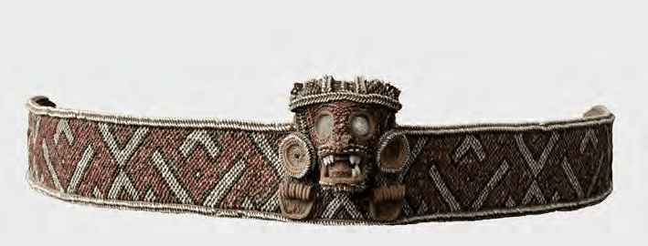
Columbus and the early Spanish sources provide a wealth of details, despite their obvious limitations and bias. For instance, these sources provide an idea of things that were considered valuable in Marien. Cotton, for instance, was common at Guacanagari's village (Columbus 128). Elsewhere, a relation of tribute received from Indians in 1495, lists gold and an elaborate belt with 4 sheets of gold given by Guacanagari (Relación del oro y joyas que recibió el Almirante después que el receptor Sebastián de Olaño partió de la isla Española para Castilla, desde 10 de Marzo de 1495"). Thus, even without control of gold mining areas, Guacanagari's chiefdom still had access to fine and elaborate gold objects, belts, and even a frog-shaped grain of gold. Villages or settlements in the region could also be rather large. Guarico, nearby, may have held over 2000 people (Columbus 130). Furthermore, the land of Guarionex was said to be located 4 days to the east. This suggests that, roughly, Las Casas, writing in Apologética historia sumaria, may have been broadly correct when he wrote that Marien covered the northern coast after Guahaba to Vega Real, including parts of the Vega Real and the sierras. It was then followed by Macorix de abajo, which included Monte Cristi. Overall, Marien covered 15 leagues or more, and likely even more territory when the hills were included. Elsewhere, in "A Short Account of the Destruction of the Indies, Las Casas claimed to have personally met several high-ranking vassals of Guacanagari (20). This is further, albeit late and problematic, testimony of Guacanagari likely possessing paramount chieftain status in the North.

Gilbert R. Valmé's aerial view of En Bas Saline and the larger Plaine du Nord region
Perhaps the most detailed yet problematic source of all is an account of Guacanagari's capital described by Luis Joseph Peguero. A writer from the Spanish colony, he may have had access to lost sources, including an account by Rodrigo Escobedo and Juan Salsedo. These two allegedly went to Guacanagari's court. One pueblo in the chiefdom, Cacuma, allegedly held 300 houses. The capital of Marien, likely today's En Bas Saline, was said to have 8000 houses of straw and wood. There were allegedly 4 streets, 4 barrios or sections, and a plaza in the center with the "palace" of the king in the midway point of the plaza (Peguero 38). It is very likely that the estimate of 8000 houses is a gross exaggeration, although Escobedo and Salsedo may have meant the larger district and not just the main settlement. Besides this estimate of 8000 houses, the capital's plaza contained a large house on its Southside where 100 soldiers and officials were (39). This may be an allusion to important elders and soldiers (nitainos) who assisted Guacanagari in the administration of the chiefdom. Later, the cacique was said to have had 25 nobles in his personal guard and a court with 8 elders (40). If he was relatively young in 1492, these elders may have been advisors who offered wisdom and practical experience in government. The Spaniards allegedly saw the temple of Marien, too. Supposedly square-shaped, made of wood and containing idols (including those fabricated with gold), the temple may have been a caney or similar structures used for various ceremonies (41). The idea of a highly ranked or stratified society also emerges in the description of the temple as having 4 separate entrances/exits for the different classes: royal family, nobles, plebeians and one only entered by the dead (used for funerary rites or rituals?). Guacanagari's palace was allegedly 32 paths long, 10 wide and divided into 4 parts. His palace included a nearby section used by 40 or more Indian women who cooked or prepared food (42). Later on, Peguero wrote of Guacanagari sending 800 archers to fight for the Spanish (73). While Peguero also blamed Roldan's rebels for burning Guacanagari's Pueblo and killing him for failing to pay tribute, other sources suggest Guacanagari died alone, in the mountains, after earning the hatred of his people and the betrayal of his Spanish allies (Nau's version of events).

Although there are obviously many questionable aspects of what Peguero wrote about Marien's capital, Deagan's work at the site of En Bas Saline partly affirms it. Settlement at En Bas Saline by people who made Chicoid pottery began about 250 years before the arrival of Columbus. It may have been a Chican intrusion into a part of northern Hispaniola occupied by Meillacoid pottery makers (36). In addition, En Bas Saline was the only known ceremonial plaza site on the coast (39). Its larger region may have stretched from the west side of Fort Liberte bay to the west side of the Bay of Acul (40). The site of En Bas Saline also covered 90,000 square meters and features public architecture (56). The central plaza covered around 50,000 square meters and featured 3 mounded areas (73). The elite mound site in the plaza was apparently 34 meters by 16 meters (98). The earliest definable building on the central mound was circular or elliptical in shape with a diameter of 12 meters (114). Using Curet's ratio of floor space-per-person, Deagan has estimated the central mound building may have housed 20-30 people (123). This could have been the 'palace' of Guacanagari described by Escobedo. In addition, the evidence for public feasting at the pits shows the communal nature of the space (129). However, Deagan did not see probable evidence for surplus storage distribution by the cacique for these feats (138). Nonetheless, she found evidence for control or organization of labor and the means of craft production at the elite mound in the plaza (232). This indicates that the cacique did exert some control over the means of production (at least for some goods). Further evidence of at least some degree of social stratification or "ranked" societies can be seen in the fact that the scarcest animals, iguanas, sea turtles, and manatees, were only found in the central mound residence and burial pit (270). This would match descriptions in the Spanish chronicles of caciques monopolizing certain types of meat and food (such as a finer quality of casabe).
Ultimately, Deagan views En Bas Saline as a "corporate chiefdom model." This may very well be true, but it seems probable that Guacanagari was not a lesser or subordinate cacique. Indeed, there was a string of villages on Haiti's North coast which were connected by an aboriginal road that ran from En Bas Saline to the modern-day Dominican republic (Keegan, 72). It is likely that Guacanagari's Marien was the most powerful chiefdom in the region and exerted influence on most of (if not all) of Haiti's northern coast. Furthermore, the cacicazgo may have been engaged in trade with Lucayans from Turks and Caicos. Keegan, who identified a prominent site (MC-6) on Middle Caicos, has found imported Chicoid pottery and speculates that the settlement likely engaged in trade with the northern coast of Hispaniola. Indeed, Keegan has even proposed that Caonabo, said to be of Lucayan origin, was from MC-6 (Keegan, 148). If so, then it is possible that Caonabo may have known of Guacanagari's chiefdom before Guacanagari became its ruler. Moreover, Marien may have been able to control trade between Hispaniola and Turks & Caicos along Haiti's northern coast.
The evidence, despite its limitations, suggest Marien truly was the seat of a paramount cacicazgo. To what extent Guahaba was fully in its sphere of influence is uncertain, but population numbers from the 1514 Repartimiento for Lares de la Guahaba and Puerto Real are suggestive of a much greater population in the area of Puerto Real (built near En Bas Saline). The population of Guahaba, whose center may have been at Gros-Morne, could have been autonomous but gradually fell under the influence of Guacanagari as he tried to use his alliance with the Spanish to increase his status. Las Casas, who at least met several of the subordinates of Guacanagari, believed it covered at least 15 leagues of territory and Moreau de Saint-Mery extended its southern border to the Artibonite. The latter even included Port-de-Paix in Marien and posited that Guacanagari commanded as many as 200,000 people! Moreover, by c.1514, there were still hundreds of Indians assigned in encomiendas far away from Puerto Real, about 317 indigenous people, whose caciques were from Marien. They might represent the core of the Marien cacicazgo's population, decimated by colonial conquest and forced relocation. One can imagine that their population in 1492 was significantly larger, and Guacanagari's chiefdom may have extended its influence across much more of northern Haiti.
Bibliography
Casas, Bartolomé de las, and Edmundo O'Gorman. Apologética Historia Sumaria. [3. ed.]. México, 1967
Casas, Bartolomé de las, and Nigel Griffin. A Short Account of the Destruction of the Indies. London, England ; New York, N.Y.: Penguin Books, 1992.
Columbus, Christopher, and Clement Robert Markham. The Journal of Christopher Columbus: (during His First Voyage, 1492-93), and Documents Relating to the Voyages of John Cabot and Gaspar Corte Real. New York: B. Franklin, 1970.
Deagan, Kathleen A. En Bas Saline: A Taíno Town Before and After Columbus. Gainesville, FL: University of Florida Press, 2023.
Fernández de Oviedo y Valdés, G., Amador de los Ríos, J., & R. Academia de la historia, M. (1851). Historia general y natural de las Indias, islas y tierrafirme del mar océano. Impr. de la Real academia de la historia.
Keegan, William F., and Florida Museum of Natural History. Taíno Indian Myth and Practice: The Arrival of the Stranger King. Gainesville: University Press of Florida, 2007.
Moreau de Saint-Méry, M. L. E. Description Topographique, Physique, Civile, Politique Et Historique De La Partie Française De L'isle Saint-Domingue: Avec Des Observations Générales Sur Sa Population, Sur Le Caractère & Les Moeurs De Ses Divers Habitans, Sur Son Climat, Sa Culture, Ses Productions, Son Administration, &c. &c. : Accompagnées Des Détails Les Plus Propres à Faire Connaître L'état De Cette Colonie à L'époque Du 18 Octobre 1789 : Et D'une Nouvelle Carte De La Totalité De L'isle. A Philadelphie: Et s'y trouve chez l'auteur ..., 1797.
Nau, Émile. Histoire Des Caciques D'Haiti. Port-au-Prince: T. Bouchereau, imprimeur-editeur, rue Courbe, 1855.
Oliver, José R. 2009. Caciques and Cemí Idols : The Web Spun by Taíno Rulers between Hispaniola and Puerto Rico. Tuscaloosa: University of Alabama Press.
Peguero, Luis Joseph, Antonio de Herrera y Tordesillas, Biblioteca Nacional, and Publicaciones del Museo de las Casas Reales. Historia De La Conquista, De La Isla Española De Santo Domingo Trasumptada El Año De 1762: Traducida De La Historia General De Las Indias Escrita Por Antonio De Herrera Coronista Mayor De Su Magestad, Y De Las Indias, Y De Castilla, Y De Otros Autores Que Han Escrito Sobre El Particular. Santo Domingo: [Museo de las Casas Reales], 1975.
Stone, Erin W. "The Conquest of Española as a “Structure of Conjuncture”. Ethnohistory 1 July 2021; 68 (3): 363–383. doi: https://doi.org/10.1215/00141801-8940494
Valmé, Gilbert R. Atabey, Yacayequey, Caney, 6000 Ans D'aménagement Territorial Préhispanique Sur L'île D'Ayiti: Haïti/République Dominicaine : Une Approche Holistique Du Patrimoine Zux Antilles : Les Paysages Culturels. Pompano Beach, Florida: Educa Vision, 2012.
