Although each update of Ancestry DNA tends to raise new problems or recreate new ones, their algorithm seems to be on the right track with indigenous ancestry in Puerto Ricans. From our own results and those of close matches, it looks like the inflated estimates are a thing of the past. Our results are quite close to 23andMe now. The next move is for Ancestry to correct their description of the region and perhaps, like 23andMe, add historical samples from pre-Columbian Caribbean populations.
Friday, October 9, 2026
Thursday, October 8, 2026
Hanyguayaba Mystery
Whilst randomly re-reading parts of Granberry and Vescelius's Languages of the Pre-Columbian Antilles, we noticed that the authors proposed defining ha or hai as the word for high in Taino. This makes sense given the name of Haiti itself, with the meaning of high or mountainous land. But what about Hanyguayaba, that poorly known chiefdom or cacicazgo in the Southwest of Haiti? Probably centered on the area of the Les Cayes plain, where the Spanish built a town after the conquest of that part of the island, the region was part of the "anus" of Hispaniola. Alternatively, we could read accept the hai in Haiti as tall or high and iti as upland or hills.
But with the word Haniguayaba, Granberry and Vescelius's hä- (han) seems to fit (meaning uppermost). This is followed by a i could mean near or eastern. So uppermost of the near guayaba (guava). But another definition might be han+i+guaya (meaning furthest back)+ba (big, great, or large). Thus, Hanyguayaba or Haniguayaba could have meant something like the "the upper, big and nearest part of the farthest" section? If one views the island through the indigenous perspective with the "anus" being the Tiburon peninsula of today's Haiti, that "behind" was quite far from other parts of the island. Perhaps the Les Cayes plain was the base for the largest area or concentration of settlements and was considered the "upper" section for its proximity to the "anus" of the island? Alternatively, reading it simply as the uppermost guava is possible? The Spanish sources from the 1500s certainly suggest the rich areas of mamey trees. Perhaps the area closer to Haniguayaba had lots of guava trees in the hills above the plain?
The guayaba reading seems more likely than our own tortured attempt at using Granberry and Vescelius, however. However, there's uncertainty about the toponym as Las Casas also presented it as Haniguayagua. Moreover, Martyr d'Anghiera did not include it among his cantons or districts in the "anus" of the island. Instead, he listed a place called Guabaqua (perhaps Guabagua?). This might have been the Haniguayagua of Las Casas? Or Zavana (or, savanna, where the Spanish settlement was built after the colonial conquest) could have been an alternative name for Haniguayaba?
Thursday, August 27, 2026
Revisiting Guarionex and Maguá
A part of northeastern Hispaniola in Alonzo de Santa Cruz's Islario general.
What
was Maguá? Often described in the early Spanish sources and later works drawing
from those texts as one of the 5 major “kingdoms” or polities on the island, it
was ruled by a cacique named Guarionex. To some extent, much is known about
Guarionex through his initial alliance and later conflicts with the Spanish.
Through the short account of Ramón Pané, even more is known about some of the
central beliefs of the “Taíno” in that part of the island. Indeed, Guarionex initially
supported the evangelization efforts of Pané. Through Las Casas and other
sources, it is also clear that Guaricano, the town or settlement of Guarionex,
was located near the initial site of Concepción de la Vega. Guarionex, who
allegedly succeeded his father as cacique of Maguá, was also said to have
controlled the plain of La Vega and ruled about 70 leagues of the interior or
middle part of the island. Since this region included the Cibao and parts of
the gold-producing centers so vital to Spanish interests, the region’s
population was incorporated into the exploitative tribute system and expected
to provide gold for the Europeans.
Yet Maguá and Guarionex remain an enigma
for those interested in uncovering more about this part of the island’s
indigenous geopolitical features before 1492. To what extent was Guarionex
truly a paramount chief? Were his domains, however loosely held together, the
better portion of Cayabo based on the Morales map of the island? Was succession
in Maguá actually patrilineal? And what happened to the sister of Guarionex
married to Diego Colón, the Indian interpreter from the Lucayan islands? To
what extent can the c. 1514 repartimiento records illuminate aspects of Maguá’s
history prior to 1492? This brief article will suggest that Guarionex’s
chiefdom was perhaps better understood as a confederacy of aligned vassal chiefs
participating in a partly ritualized network. This will become evident through
a cursory examination of the various chronicles and relevant archival documents
pertaining to the early colonial period. Though tentative, it shall be seen that
Wilson’s view of Guarionex as a “first among equals” within his greater cacicazgo
is the most appropriate model.
Let us begin with the nature of Maguá as
the center of a paramount chief in the colonial sources. The earliest written
attestation of Guarionex derives from Columbus’s journal of the first voyage in
1492. Mistakenly believing the locals referred to Guarionex as a separate
island where gold could be found, he believed Guarionex was an island to the
east.[1] This established quite
early for Columbus that the territory of Guarionex must be explored and
exploited. When Columbus next wrote of Guarionex, he knew better. According to
his October 14, 1495 letter, “Guarionex, el cual (es) uno de los tres caçiques
mayores de la isla porque él me avía enbiado muchas vezes presentes e a dezir
que le plazía de fazer todo lo que yo horderase, y era enemigo d’este Cahonaboa
y (a) esto también, porque no se conformase (ny) con otros caçiques para (ir)
contra nosotros.” By the end of the letter, Columbus also referred to
Guarionex’s sister marrying the Indian interpreter, Diego Colón.[2] Clearly, by 1495, Columbus
understood that Guarionex was the name of a powerful cacique who was also
interested in an alliance with the Spanish. Moreover, by stressing his enmity
toward Caonabó and his marriage alliance with the interpreter of Columbus, a
man who would have been central in all negotiations between Columbus and the
cacique, Columbus saw in him a powerful and essential ally.
As one can expect, sending Pané to
Guarionex’s region was therefore a critical strategic move on the part of
Columbus. By endeavoring to evangelize his region and have missionaries learn
the universal language of the island, Taíno, instead of the Macorix tongue, the
Spanish could begin to increase their influence. To what extent Guarionex was
one of the most powerful caciques of the island is still an unanswered
question, but control of gold-producing areas and his influence on other
caciques may have convinced the Admiral and Adelantado that they had to work
through him. Moreover, through Pané’s short account of Indian “antiquities” and
their notions of religion or spirituality, one has a glimpse of the role of the
cacique and cemís in establishing the chief’s authority. For instance, Pané’s
account includes references to what seems to have been the father of Guarionex
(“Guarionel”), specifically linking him to the cemí known as Baraguabel.
Moreover, Guarionex’s father allegedly told the prophecy from Yucahuguama in
which clothed strangers were predicted to come to seize the land.[3] Undoubtedly, caciqual
authority was tied to the veneration and communion with cemí figures. Moreover,
the prophecy in which Guarionex’s father was involved highlights one of the
roles of the cacique as an intermediary between his subjects and powerful cemís.
Of course, if the prophecy was already discussed in 1494 when Pané was
endeavoring to spread the gospel in Guarionex’s territory, then some of the
locals harbored negative views of the Christians. Yet when a coalition of
caciques attacked the Spanish in 1495, Guarionex did not join. Indeed, even
after abandoning Christian prayer and becoming hostile to them, he did not
directly join the coalition. Intriguingly, Pané also referenced Guarionex’s
mother, referring to her as “the worst woman I have known in these parts”
without explanation.[4]
In addition to Pané and Columbus, an
allusion to Guarionex from 1495 may be found in a report on the tribute
received in gold and jewels by the Admiral. The list of tribute included gold
brought in La Concepción and Santo Tomás by some caciques.[5] Since La Concepción was
built near Guarionex’s settlement and he was expected to provide a large amount
of gold in tribute to the Christians, one can surmise that Guarionex was part
of this group of caciques who presented gold. As the cacique with a degree of influence over several other caciques, this presumably meant naborías or commoners were expected to
pan for gold in streams and provide it to the caciques to pass on to the
Spanish. Due to insatiable Spanish demand and the unfamiliarity of the Taíno
with gold mining on a scale Europeans would have liked, one can imagine these
tribute demands were perceived as onerous by subjects of Guarionex and his
vassal chiefs. Consequently, he attempted to change the tribute to one of
agricultural products, to no avail. Nonetheless, it illustrates one way
caciques exerted their authority over their subjects: labor tribute for gold,
yucca or other products.
Besides these early allusions to Guarionex
by Columbus and Pané, other sources on him were composed later and relied
heavily on oral reports or the writings of Columbus and others. Thus, Peter Martyr
d’Anghiera, in De Orbe Novo, referred
to a “Guarionexius” valley beyond the Cibao, falling under the remit of caciques
called Guarionexius through patrilineal succession. This valley was allegedly
190 miles long east to west, and 30 to 50 miles broad at its widest. Beginning
at Canabocoa, it crossed Huhabo and Cahibo, ending in Bainoa at the district of
Mariena.[6] Supposedly, Cibao,
Cahonao, and Cazabucana bordered it. If one can make sense of this description,
the name Guarionex may have been a title used for the ruler of this valley,
which may have been a hereditary position. If it ended at Mariena, or Marien, Guacanagarí
was in Guarionex’s sphere of influence or very close to it. Cacacubana was said
to have been at least partly inhabited by Macoris speakers. If Guarionex’s
domains really did border upon those of Guacanagarí of Marien, one can see why
the latter may have been so interested in forging an alliance with Columbus.
Las Casas and Oviedo are also very
important later chronicle authors who touch upon Guarionex’s chiefdom. Oviedo,
who did not arrive on the island until over a decade after Guarionex’s death,
relied on the testimony of earlier settlers and perhaps written sources.
According to Oviedo, Guarionex ruled all the plain and more than 70 leagues of
land in the middle of the island. Furthermore, Guarionex and 14 (other sources
claim 15) other caciques battled the Spanish near the site where Bonao was
built. Although they were defeated, Oviedo believed that Guarionex only made
peace after his wife was seized by the Spanish. He also claimed Mayobanex was a
captain general of Guarionex, perhaps illustrating Oviedo’s reliance on oral
sources that conflated different moments of Guarionex’s career.[7]
Las Casas, on the other hand, provided a
more detailed account and benefitted from his earlier arrival on the island.
For example, he is one of the few chroniclers to name Guarionex’s settlement
(Guaricano). He also identified one of the vassals of Guarionex who was “lord”
of the Cibao, said to have mustered 16,000 men for war when called upon by
Guarionex.[8] This could be an allusion
to the alleged 15,000 Indians raised by Guarionex and Indian allies against
Bartolomé Colón.[9]
If so, then the Cibao cacique was probably not capable of solely raising 16,000
men. It nonetheless speaks to the great resources in people of this part of the
island. Indeed, later sources estimate that the Cibao may have had a population
of 90,000 inhabitants in c. 1492.[10] With access to such an
ample supply of labor, Guarionex could easily appear to the Christians as one
of the most powerful caciques on the island.
Besides the chronicles, a few additional
insights into the nature of Maguá and its nearby regions may be found from the
16th century. The 1514 Repartimiento records demonstrate that La
Concepción de la Vega’s vecinos continued to enjoy the fruits of the
labor of a large part of Hispaniola’s remaining indigenous population. Several
caciques whose communities were assigned to encomenderos in La Concepción
included names such as Almirantico, Ayraguay, Lucas de Cotuy, Guacoquex,
Macote, Manicaotex and others. Among these caciques was Diego Colón, the
translator of Columbus who had learned the Spanish language and traveled to
Europe.[11] Diego Colón’s group only
included 15 Indians assigned to Pero Lope de Mesa, yet one cannot help but
wonder if Diego Colón’s claims here were reinforced by his marriage to
Guarionex’s sister. Despite Guarionex’s death in 1502, and his earlier flight
to the lands of Mayobanex which may have ended any influence of his family in
Maguá, perhaps Guarionex’s sister was still alive. Lingering claims to
authority or status among the indigenous peoples near La Concepción may have
been associated with her as the sister of the last cacique. Regardless, by 1517,
Diego Colón was considered a failure in terms of leading an indigenous group
freely, despite his education.[12] Further, the distribution
of the indigenous population assigned to encomenderos here may have been
significantly reshaped by 1514, particularly by population losses,
displacement, and the demands of the encomienda system.
Subsequent sources during the colonial era
add little. The biographer of Columbus, Fernando Colón, attributed Guarionex’s
joining of a plot against the Spanish to a Christian seducing or assaulting his
wife.[13] If true, this shows how
much it took for Guarionex to finally sever his initial alliance with the
Spanish. Moving into the 1700s, Luis Joseph Peguero merely described a large
plaza near the “palace” of Guarionex in his settlement. Supposedly the
population reached 10,000 houses, but one must interpret these figures carefully
given the exaggerated numbers in the chronicles upon which Peguero based his
work.[14] Émile Nau, the 19th
century Haitian historian, mistook the relative of Guarionex married to Diego
Colón for the cacique’s daughter. But little else is reported besides the
fanciful theory of Nau that the Ciguayos were relatives of the Caribs based on
their bellicose nature.[15] Little is reported here
that can be used to ascertain the nature of the Maguá cacicazgo’s
political organization.
Fortunately, the picture improves with
more recent scholarship on the indigenous peoples of the island. Sven Loven emphasized
the densely populated nature of Maguá, suggesting it surpassed all other parts
of the island.[16]
Ricardo Alegría, in his MA thesis, endeavored to define the borders of Maguá,
which may have encompassed lands from the Cape of San Rafael to Macorix on the
north coast, including the central, lower and best parts of the Cibao valley.
In addition, Guarionex supposedly had 21 nitaínos serving under him, with
villages at Batey, Sabanacoa, Corojay, Cotuy, Cabao, Ciguayo, Tuna, Guayhamaca,
Goacoa, Janique, Marien, Maymon, Majagua, Macorix de Arriba, Majonix, Maguey,
Manicu, Samana, Yaguax, and Yaguahayucu.[17] Alegría likely
overextended the domains of Maguá’s cacique, although the chronicles suggest at
least 14 or 15 caciques were aligned with Guarionex in some fashion.
In the second half of the 20th
century, newer studies raised novel questions or approaches to interrogate the
chronicles on the nature of Taíno sociopolitical organization and the
geopolitical configuration of Hispaniola in 1492. Scholars such as Bernardo
Vega sought to analyze the map of Morales, the chronicles, and other sources to
address the borders of the cacicazgos and how indigenous peoples divided
the island. Based on the map of Morales, we know that the Caihabo section
included Maguá, Cocacubana, Cubana, Dahaboon, Cybaho, Manabaho, Cotoy and Baiohaigua.
Guarionex’s territory, based on Martyr d’Anghiera, may have stretched from Moca
to Fort Liberté and definitely included the area where the Spanish built Concepción
de la Vega.[18]
Vega has also suggested that the Ciguayos occupied the area from Cubao to
Macao, from La Vega to Higüey. Maguá itself may have meant valley in the Taíno
language. Ultimately, the value of Vega’s intervention here is to question the simple
5 paramount chiefdom model for the island.
On the other hand, some scholars accept
the other divisions of the island from the Morales map and Martyr d’Anghiera
whilst retaining the paramount chieftaincies model. Gilbert Valmé wrote of the
grand village of Guarionex on the Rio Verde as having a population of more than
5,000 people. Maguá, perhaps encompassing the valleys of the Yuna and Camu
rivers, was the complex cacicazgo dominating a much larger region.
Indeed, Valmé even claims the batey of Guarionex’s village was 15,972 square
meters.[19] With its large population
and access to river systems and exchange with the coast, Maguá would have been
the center of a densely packed region. The spiritual cemí powers and
connections of Maguá’s chieftains may have also played a role in their influence
on other caciques in the Cibao and nearby locations. For instance, the belief in
the cave site of Cacibajagua as an origin for humans on the island could have
encompassed ritual pilgrimages and larger networks of kinship that connected
Maguá’s rulers with other caciques. In fact, Oliver has suggested the gifting
of an areito by Guarionex to the non-Taíno Mayobanex may have been so powerful
because it tied that cacique to the cemífied ancestors of Guarionex and Maguá’s
leadership.[20]
Undoubtedly, the most sophisticated
analysis of Guarionex and the Maguá chiefdom can be found in Wilson’s important
study of the chiefdoms of the island. For Wilson, the existence of several
large villages by the Rio Verde attests to the region’s large population on the
eve of European contact. But in the eastern Vega Real, higher levels of
rainfall would explain the greater density of population.[21] This would have made
Guarionex especially powerful if successful in leading the complex chiefdom’s
network of vassal chiefs, as their laborers could be expected through tribute
to supply many resources. However, in some respects Guarionex’s position was
more of a primus inter pares among the region’s chiefs. He had to use
persuasion, kinship, gifts, or displays to ensure other caciques obeyed.[22] Thus, the nature of
Guarionex’s authority was hardly despotic and required skillful and dynamic
leadership to meet new challenges and maintain the allegiance of the various
vassals. This can be seen in his involvement in the 1497 attack against the Christians,
which Guarionex may have only joined after the attack on his wife. Certainly,
in 1495, Guarionex preferred to maintain peaceful relations with Columbus while
some of his subjects desired to use violence. Later, by the time Guarionex fled
to the land of Mayobanex, he may have already lost the fragile coalition he
once dominated in 1492.
Unable to meet the challenge posed by
onerous gold tributes to the Christians or maintain peace, Guarionex fled his
lands and later died after years of imprisonment. The story of his capture recalls
the ignominious fall of the Haitian, Charlemagne Péralte, during the US
Occupation.[23]
Nonetheless, Guarionex’s case and the Maguá cacicazgo appear to have
been a confederacy exerting great influence over much of the northeastern and parts
of central Hispaniola. Control of or influence over regions which held much
mythological or symbolic importance, as well as the cemí spirits tied to his lineage
and their oracular powers, likely increased Maguá’s power over large swathes of
Cayabo. Nonetheless, the nature of this power or authority was likely not very
centralized and may have required persuasion, kinship links, ritual feasting
displays, gifts, and astute political leadership to maintain. Due to the relatively
large population concentrated in this part of Hispaniola in precolonial times,
one may assume this access to the labor of the commoners increased Maguá’s
power. And even though gold was not mined in a highly productive manner, access
to gold deposits as well as other resources likely increased Maguá’s influence
on the island of Hispaniola. It would be interesting to compare more closely
Maguá and Xaragua as the two polities of the island which appear to have been
more effective confederations dominated by chiefly families. In the case of
Xaragua, the lack of adequate rain was met through irrigation ditches. The absence
of gold was compensated for by Xaragua’s excellent woodcarving and cotton,
which could have been items of exchange with Maguá for gold. One also wonders
if the marriage of Anacaona to Caonabó was perhaps intended to support a buffer
chiefdom against Maguá’s influence in the northeast.
[1] Cristóbal Colón, Consuelo Varela Bueno and Juan Gil
Fernández (editors), Textos y documentos
completos, 182.
[2] Ibid., 316.
[3] Fray Ramón Pané, Susan C. Griswold
(trans.), An Account of the Antiquities of the Indians, 30-31.
[4] Ibid., 37. Was she sexually
promiscuous or possessed too much political power?
[5] “Relación del oro y joyas que
recibió el Almirante después que el Receptor Sebastián de Olano partió de la
Isla Española para Castilla , desde 10 de marzo de 1495” in Colección de
documentos inéditos relativos al descubrimiento, conquista y organización de
las antiguas posesiones españolas en América y Oceanía, sacados de los Archivos
del Reino, y muy especialmente del de India, Tomo X, 7.
[6] Probably Marien.
[7] Gonzalo Fernández de Oviedo y
Valdés, Historia general y natural de las Indias, primera parte, 61.
[8] Bartolomé de las Casas, Apologética
historia sumaria, 2654.
[9] Bartolomé de las Casas, Historia
de las Indias, Vol. 2, 145.
[10] Alfredo Bueno Jiménez, Virginia
Flores Sasso, y Esteban Prieto Vicioso. 2026. «Las Resistencias Tempranas En
Cibao y La cuestión Del Santo Cerro, 1494-1497». Fronteras De La Historia
31 (2), 82-83.
[11] Arranz Márquez, Repartimientos
y encomiendas en la Isla Española: El repartimiento de Albuquerque de 1514, 555.
For more caciques in this area, 555-558, 569, 589. Caciques attached to encomenderos
in Santiago, La Concepción and perhaps Puerto Plata may have once been part of
the confederacy-like chiefdom of Guarionex. In terms of caciques with the
largest number of Indians, Ayala, Barahona, and Diego Enrique each led over 100
Indians. Another, Ynamoca de Casambanas can join this list. In Bonao, a cacique
named Francisco, one of the more Westernized indigenous leaders, led many
people split between 3 different encomenderos: 94. Meanwhile, Santiago
had Lucas Vazquez de Ayllon, served by 191 Indians under a cacique named
Escobar.
[12] Hieronymite Interrogatory in
Emilio Rodríguez Demorizi, Los domínicos y las encomiendas de indios de la
Isla Española, 318. A few other educated or acculturated caciques were
considered also incapable of living without the tutelage of the Christians,
such as cacique el Dotor in Santiago and don Francisco in Bonao.
[13] Fernando Colón, A. Fournier (trans.),
Histoire de la vie et des voyages de l’amiral Christophe Colombe, 387. The
violence and outrages committed by the Europeans against indigenous women were
a frequent cause of unrest.
[14] Luis Joseph Peguero, Historia
de la Conquista de la isla Española, Tomo Primero, 67-68.
[15] Émile Nau, Histoire des
caciques d'Haïti, 127, 186.
[16] Sven Loven, Origins of the Tainan
Culture, 76, 529. He also claimed Mayobanex had given one of his wives to
Guarionex, a claim we have not seen in the sources.
[17] Ricardo Alegría, “Cacicazgo Among
the Aborigines of the West Indies,” 76.
[18] Bernardo Vega, Los Cacicazgos
de la Hispaniola, 17, 26.
[19] Gilbert Valmé, Atabey,
Yacayequey, Caney: 6000 ans d'aménagement territorial préhispanique sur
l'île d'Ayiti: Haïti/République Dominicaine: une approche holistique du
patrimoine aux Antilles: les paysages culturels, 178, 181, 225.
[20] José R. Oliver, Caciques and
Cemi Idols: The Web Spun by Taino Rulers Between Hispaniola and Puerto Rico,
107-108. One can see this perhaps being used by Guarionex’s predecessors to
consolidate their chiefdom’s hegemonic position in La Vega and Cibao, extending
or contracting based on the skills of the caciques in politics. When Guarionex
failed to successfully eradicate the destructive impact of the Spanish tribute
system, he appears to have lost support in the coalition Maguá once dominated.
In fact, when he fled to the territory of Mayobanex, 3000 Indians joined the
Spanish against him and his allies there. Even Mayobanex’s people wanted
Guarionex to be surrendered to the Spanish to end the Christian attacks on
their communities. See Anderson-Córdova, Surviving Spanish Conquest: Indian Fight,
Flight, and Cultural Transformation in Hispaniola and Puerto Rico, 190.
[21] Samuel Wilson, Hispaniola:
Caribbean Chiefdoms in the Age of Columbus, 80-81.
[22] Ibid., 102.
[23] Ibid., 107. The 12 Christians who captured Guarionex and Mayobanex used bixa to change their skin color to black and red, then sneaked into the area where Mayobanex and Guarionex were hiding. Blackface was also used by the US Marine who captured Charlemagne Péralte.
Monday, August 24, 2026
Chalirati
Whilst randomly searching through the Drake Manuscript online for another topic, we came across a familiar animal. Called chalirati here, we suspect it to be a deformation of a Kalinago word for the ray, Chibáli. According to Breton's dictionary, the word was also used to describe the arrows made using the tail of this animal. By the 1600s, the word for the arrow made from the tail of this ray was also used to describe mixed-race people born to Indian men and black women among the Caribs, chibárali. Yet for blacks without any Amerindian admixture, the word used for them was the Kalinago term for the black triggerfish, chiboulli. Why the term for a mixed Black/Indian person was the same as that used for an arrow tipped with the tail of a venomous ray is not clear, but could have been connected to the skin color of such individuals and the ray in question? Based on the Drake Manuscript, it seems to have been brownish in color?
We are still curious about the other terms used by the Kalinago for mixed-race blacks. One term, cachionna, which may be linked etymologically to the Arawakan-derived term for the Sun among the "Island Caribs." This word was used for children born to white men and black women, as well as Indian men and black women.
Monday, June 22, 2026
A Tentative Reconstruction of the Maguana Chiefdom, Hispaniola
Exploring the history
of the cacicazgo of Maguana is
exceedingly difficult. Caonabo, its leader at the time of Columbus's arrival in
Hispaniola is one of the few figures from its precolonial past of which some
written sources exist. Speculation and the use of the meager details of his
life are among the best clues available to researchers. In addition, the
topography of the island, Maguana's relations with other cacicazgos and the traditions of Indian misterios which
have survived in the region of San Juan de la Maguana are the other types of evidence
one must consult. Besides these aforementioned sources, the brief references in
the Spanish chronicles and some of the encomienda
records are most of what one can work with. This paper will draw on the
chronicles, Columbus's writings, and other types of sources to reconstruct a
plausible theory for Maguana. Then, with a review of 20th century scholarship
and more contemporary studies, we shall endeavor to understand the features of
the Maguana chiefdom. It will be shown that Caonabo's political career and
function as a stranger king made him, more than any other cacique, well-poised
to understand the threat the Spanish posed to the balance of power on the
island.
Non-Spanish
Early Sources
First, the non-Spanish
chronicles and histories. Moreau de Saint-Mery wrote that Maguana was bordered
to its south by the sea, on its north by the mountain chains, on its east by
the Jayna (Haina) River, and on its west by the mountains of Bahoruco.[1] For Charlevoix, the Jesuit
historian, Maguana included the Cibao. Its leader, Caonabo, was the most
powerful monarch on the island. Supposedly, Maguana was able to, with the aid
of its allies no doubt, muster 100,000 warriors led by Manicatex, a brother of
Caonabo.[2] Cuneo, a much earlier
source, attributed the total forces Caonabo was capable of mustering to be
50,000, so one may presume Manicatex was receiving reinforcements from a
broader alliance.[3]
Nau, the 19th century Haitian historian of the island's indigenous peoples,
repeated the narrative of Caonabo's Carib origin. One of Maguana's provinces
included Niti, too.[4]
Unsurprisingly, Nau likely drew on the same sources as the earlier Francophone
chronicles and texts.
An anonymous Frenchman
writing in the 1700s, who presumably drew on oral tradition, also wrote about
Caonabo. In his case, the treasure of Caonabo was thrown in the river by a wife
after she heard the god of the Spanish was gold. This lost treasure apparently
consisted of 300 plaques of gold, 52 charges of gold, a throne (presumably
a duho) and a gold table. Locals even reported that the treasure of
Caonabo was still somewhere in this river.[5] Moreover, the region
around San Juan de la Maguana was perceived by some non-Spanish writers as a
part of the island in which people with mixed-race Indian ancestry could be
found.[6] Thus, even into the 17th
century, the area around San Juan de la Maguana had a partly recognizable
indigenous heritage. Indeed, even Thomas Madiou reproduced a discourse by a
commandant of San Juan de la Maguana from the 1820s which reiterated the notion
of indigenous ancestry.[7]
Last, but certainly not
least, Robert Schomburgk visited the site of the Corral de los Indios, a
ceremonial center that is often said to be the largest plaza in the Caribbean.
Although Schomburgk referred to it as a "Cercado de los Indios," it
is obvious he was referring to the same corral.[8] Its tremendous size and
the use of a rock with evidence for eyes and a mouth near the center of the
plaza must have held some kind of cosmological or ritual significance.
Despite their
limitations, these pre-20th century French and English sources do give a sense
in which indigenous traditions may have survived in the region of San Juan de
la Maguana. Naturally, this could very well be part of the legacy of Maguana
and provide possible clues to the region. Consequently, the association of
water with indigenous spirits in the region today could very well be an example
of indigenous retentions.[9] Taken together, these
non-Spanish accounts of Maguana’s martial strength, its lost royal treasure,
and the persistence of its sacred landscape into the colonial and even the
nineteenth century depict a paramountcy substantial enough that Caonabo’s rise
to its head, as a political outsider, demands explanation — a question the
Spanish-language sources, and the stranger king model explored later in this
essay, help illuminate.
Spanish-Language
Early Sources
Moving on to Spanish
writings, the language of all the primary sources, scholars have additional
details and more questions. First, Columbus and others who visited Hispaniola
in the 1490s provide the earliest written sources to mention Caonabo or areas
allegedly part of his domains. For example, Columbus, who met Caonabo, referred
to him as "a man advanced in years and of great knowledge and very keen
understanding.”[10]
This suggests that Caonabo was perhaps middle-aged or older by this time. He
was not young or politically inexperienced, as Guacanagari of Marien may have
been. In fact, Columbus's journal entries on the First Voyage likely allude to
parts of Caonabo's territory when referring to places east of Marien:
Guarionex, Macorix, Mayonic, Fuma, Cibao, and Coroay.[11] It is highly likely that
the Cibao was part of Caonabo's territory, and Mayonic could have been
Columbus's garbled rendering of Maguana. In his other writings, Columbus
similarly described interactions with Caonabo and the land of Maguana. For
instance, he knew of "Cahonaboa" as "el cual posee tierra en que
ay mucho oro.”[12]
Elsewhere, in a
memorial from 1494, Columbus referred to Caonabo as "que es ombre, según
la relación de todos, muy malo e muy más atrevido.”[13] Clearly written during
the period of conflict with the powerful native ruler, Columbus acknowledged
the bold daring of Caonabo. This is why Columbus urged the sending of European
gifts to Caonabo to help lower his guard. The giving of gifts was quickly
understood by Columbus to be important in establishing close ties with the
indigenous elite of the island. But on Maguana specifically, Columbus's
writings report "y este Cahonabo dizen que en la tierra donde vive ay
mucho oro mas es tierra muy montañosa."[14] Upon consideration of
Caonabo's name, translated as "Lord of the Golden House" by Martyr d'Anghiera,
the cacique's territory must have included gold-producing parts of the island.
When he visited Maguana itself in 1495, Columbus noted the land's proximity to
the sierras and its acequias or irrigation ditches, "como
en Granada," to exploit the plentiful sources of water.[15] This reference to the use
of irrigation canals or ditches is especially significant. Since the use of the
same method of irrigation was used in Xaragua, whose leader at the time was a
brother-in-law of Caonabo, one is tempted to consider a technological transfer
from Xaragua to Maguana. Alternatively, both regions may have begun using
irrigation systems much earlier. Regardless of the origin of this practice, it
would have greatly increased the agricultural potential and provided higher
population densities. This could explain the large number of houses in
Maguana's central settlement, which Lynne Guitar claimed exceeded 1000.[16]
In addition to
Columbus, a plethora of other Spanish sources and chroniclers of the first half
of the 16th century mentioned Caonabo and Maguana. For instance, Martyr
d'Anghiera's De Orbe Novo gave a translation of Caonabo's
name. Furthermore, based on Morales's map of Hispaniola and other sources,
d'Anghiera located Maguana in Bainoa. Maguana itself was a valley through which
the Bahaun River flowed. Caonabo's siege of Alonso de Ojeda in the Fort of
Saint Thomas was also mentioned, including the bewildering tale of Caonabo's
capture and imprisonment by Ojeda. Like Columbus, d'Anghiera also stressed that
Caonabo ruled "Cipangu" (a misunderstanding on the part of Columbus
for the Cibao, mistakenly identifying it with Japan). But with a much smaller
estimate of warriors, Caonabo's brother was only able to gather 5000 men. And
they were defeated by the Spanish (with the brother's capture, too).[17] Ferdinand Columbus, the
son of the Admiral, also referred to Caonabo in his biography of his father. In
this case, it was to the enmity between Caonabo and Guacanagari, as the former
had stolen the wife of the other.[18] Although Columbus's son
offered a different narrative of Caonabo's capture, the general picture is
consistent with the other sources on Caonabo's destruction of La Navidad and
conflict with the Spanish. Las Casas, on the other hand, provided a richer
description of Maguana. For this author, Maguana was located near the Cibao and
consisted of valleys, rivers, plains, and sierras. It was fertile, enjoyed a
moderate temperature, and the Yaqui river passed through its territory.
Maguana's name referred to the fact that it was a smaller vega than Maguá,
the cacicazgo held by the family of
Guarionex.[19]
Las Casas even gives some dimensions for Maguana, cited by Sued-Badillo as
being 30 leagues long and 25 leagues wide.[20]
The other 16th century
sources include Oviedo's Historia general y natural de las Indias and
the records associated with the 1514 Repartimiento. Oviedo, who came to the
island long after the demise of Caonabo, believed the cacique was of Carib
origin. Moreover, he also saw the Ciguayos as subjects of Caonabo.[21] This seems unlikely if
the Ciguayos were based in Samaná, closer to the territory of Guarionex.
The 16th century records on the encomiendas
of San Juan de la Maguana and other towns in c. 1514 also allude to some
details on Maguana. Of the 1,435 Indians assigned to encomenderos there, some were from the western part of the island.
For example, a cacique named Baltasar de Higuamuco likely came from the
territory Las Casas described as east of Guahaba. Others who likely came from
the cacicazgo of Maguana in
precolonial times were assigned to encomenderos
in other towns. Thus, Hernando del Maguanabo, perhaps his name referring to
"House of Maguana," was assigned to Diego de Ocampo in Bonao.[22] Although his following
only consisted of 45 people, his name is highly suggestive of someone who may
have hailed from the precolonial Maguana elite. Other familiar names among the
indigenous leadership include Enrique, who later led a long-lasting revolt
against Spanish authority from the Bahoruco Mountains. As the nephew of
Anacaona, the wife of Caonabo, his presence in the Bahoruco area and San Juan
de la Maguana must have held some appeal to indigenous people who remembered
Caonabo for his fierce resistance to the Spanish.
Another cacique who may
have been tied to Maguana was Manicaotex, assigned to an encomendero in La Concepción with 79 indigenous people in his
community.[23]
There is no evidence this is the same person as the brother of Caonabo with the
same name, but a connection is possible. In fact, the name is reminiscent of
the Taíno word manicato, perhaps signifying a bold leader.
Another cacique who may have been originally from the area of San Juan de la
Maguana (or Azua, likely part of the larger cacicazgo
of Maguana) was Alonso de Ojeda. Though assigned to an encomendero in La Buenaventura, the Hieronymite Interrogatory of
1517 specifically named him as one of the caciques who conspired to flee and
resist Spanish attempts at forced relocations.[24] With 135 indigenous
people under his leadership, he may have been one of the more important
caciques in the Maguana and Azua area.[25] Read as a whole, this
Spanish testimony situates Caonabo less as a native son who quietly inherited
Maguana’s leadership than as a figure who had to actively command its irrigated
wealth, its gold, and its alliance with Xaragua, and whose authority over the
dispersed caciques later recorded in the 1514 Repartimiento appears to have
been built and defended rather than simply assumed — precisely the profile a
stranger king model would predict.
Lingering
Questions and Modern Sources
After reviewing the
French and Spanish (and one English article) sources on Maguana before the 20th
century, there are many questions which remain. Were Maguana's dimensions as
given by Las Casas accurate? Was Caonabo a Lucayo or Carib? To what extent were
the people in the Bahoruco and areas near the modern Haitian border part of his
domains? And was his marriage with Anacaona a later development in his life
after he consolidated his power at the head of Maguana? Undoubtedly, the
marriage alliance with Anacaona strengthened his political position among the matunheri caciques of the island. One
wonders if Caonabo's political rise, despite his foreign origins, was tied to a
guatiao or fictive kinship link with
the previous lineage of Maguana. Or, was Caonabo a Lucayo or
"Carib" related to the ruling dynasty of Maguana? The question of
Caonabo's three or four brothers and the apparent succession of the throne to a
brother might be an indication of maternal lineage rooted in the region.
Perhaps Caonabo's branch was able to seize power through the effective military
leadership of Caonabo. Furthermore, one wonders if the Uxmatex, a cacique and
captain of Caonabo, was another one of his brothers.
Moving into the 20th
century, several secondary sources shed further light on Maguana with the aid
of ethnohistory and newer approaches to the archive. The 20th
century Dominican historian, Casimiro Moya, speculated that the territory of
Maguana encompassed the Cibao, Maniey, Azua and Banique.[26] Sven Loven, author of a
masterpiece on the indigenous Caribbean, seemed to prefer Caonabo as a Lucayo
whose success in wars preceded his ascent to the position of cacique of Maguana. He also believed
that the Corral de los Indios was a sanctuary site. The crown of Caonabo was
also described as having wings and gold-encrusted eyes.[27] Samuel Wilson, based on
Las Casas, recounted how Caonabo was captured and the brass bell of La Isabela
that could talk.[28]
Intriguingly, the fact that it took 18 months before Behechio of Xaragua tried
to annex parts of Maguana after the fall of Caonabo was also important, perhaps
showing how the defeat of Caonabo and his brother destroyed the paramount
chiefdom's stability.[29] E.W. Stone likewise
proposes the sacred spaces held by Maguana included El Cacique de Charco de los
Indios, Río Chacuey, Cueva Pomier, and Pico Duarte would have enhanced the
status of Caonabo.[30]
Besides these 20th
century sources, several additional scholars have analyzed aspects of Caonabo's
life or the Maguana cacicazgo. Valmé, drawing on a perhaps erroneous method,
estimated that the Corral de los Indios site's batey, of 37,994 square meters, could have held 11,400 people.
Moreover, Maguana contained more than 45 drainage basins, another sign of the
area's agricultural potential and attraction to people.[31] Bernardo Vega, who drew
heavily upon the map of Morales and other sources, problematically asserted a
Ciguayo origin for Caonabo but failed to provide evidence.[32] Cassá,
however, theorized that Caonabo wanted to use Christian cemí power in his war against the Spanish, which could be why
Caonabo was willing to accept European gifts.[33] Deagan, in her study of
En Bas Saline, the probable site of Guacanagari's capital, has also cited
sources on Columbus enslaving 600 of Caonabo's subjects in 1494/5.[34]
Significantly, Jean
Fouchard, the Haitian historian, also proposed that a Haitian "Chant de
guerre de Caonabo" from the 19th century is an authentic specimen of
indigenous literature. First published in La Selve's study of Haitian
literature, the song is full of Kalinago words like boutou. There's
also a proposal that Caonabo was from Guadeloupe, which is interesting since
the indigenes of Guadeloupe were in contact with Puerto Rico.[35] It is not implausible for
an adventuresome Kalinago from Guadeloupe or the Lesser Antilles to have
reached Hispaniola, too. But the chant's fusion of mostly Kalinago words with a
few examples of Taíno words seems more typical of a 19th century Haitian
literary style, which sometimes conflated Kalinago and Taíno cultures. Thus,
the song is full of words like kouroumon
and bayakou. The song also refers to
Guacanagari as a traitor, which does match how chroniclers described the
animosity between Guacanagari and other caciques
of Hispaniola.[36]
Since the song's origins are unclear and it is unlikely to be an authentic war
song from 1492 or 1493, it is perhaps better seen as an example of how 19th
century Haitian authors imagined the areyto. Nonetheless, the
claim of an origin in Guadeloupe for Caonabo is not outside the realm of
plausibility and has at least some basis in the Spanish chronicles.
The most important
sources on Caonabo, however, are the works of Keegan and Ostapkowicz. The
former, author of a study on Caonabo as a stranger king, draws extensively on
his own archaeological research in the Lucayan islands. Keegan has also tied
the notion of Caonabo as "Carib" to a Taíno mythical geography.
Moreover, the references in the sources to Caonabo and his three brothers are
reminiscent of Deminan and his three brothers in Taíno myth.[37] If Caonabo was a wise,
stranger figure whose life could parallel important figures in Taíno mythology,
this model may elucidate how he was able to ascend to the status of most
powerful cacique on the island.
Keegan even suggests that he could have been the guardian of the mythical cave
of origin, Cacibajagua, if it was included in his domains.[38] Of course, the author has
argued against the location of Cacibajagua in the domains of Caonabo,[39] but the central location
of Maguana and the gigantic plaza at El Corral de los Indios likely has
cosmological significance that went beyond the confines of Maguana. In terms of
archaeology, Keegan has identified a possible site for an important village
Caonabo may have come from: the MC-6 settlement established no earlier than
1300.[40] If Caonabo was indeed a
Lucayan, as indicated by Las Casas, he could have come from this important,
cosmologically charged site that was linked to Hispaniola. Indeed, Maguana may
have represented the center of the island and the center of the world from the
perspective of the indigenous peoples, a notion also shared by Valmé.
Ostapkowicz, on the
other hand, brings a keen attention to detail and textual sources with a study
of Taíno material culture. In her thesis, a study of the duho,
Columbus is cited for Caonabo's explanation that every principal cacique of the island believed that
after death, people go to a valley where they see their ancestors, eat, access
their wives, and more. Caonabo explained that every cacique believed the valley of the afterlife was located somewhere
in their own territory, perhaps implying that Coabay was not located in a
single place.[41]
In her recent study of cloth and fibrous materials, Ostapkowicz delves into an
analysis of various items received in tribute from Caonabo's community in 1495.
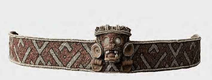
A combination of belts, masks with gold parts, naguas, hammocks, cotton, and sheets of gold were collected from
Caonabo's Indians.[42] The presence of much
material using cloth, though not as much as the cloth and textiles found in
Anacaona's storehouse, indicates the degree to which cotton and textiles were
part of the wealth of a cacique. As
one of the most powerful caciques,
and one whose name referred to gold, it is striking how so much of the tribute
collected from Caonabo's subjects consisted of cloth. While gold was used with
the masks and other objects given to the Spanish, one can detect a similar
sense of value and wealth in Caonabo's Maguana as that of Xaragua. Given the
close ties between Xaragua and Maguana, as well as the use of irrigation canals
in both chiefdoms, perhaps cotton was one of the additional sources of wealth
for Maguana. Alternatively, cotton may have been given in gift exchanges
between Xaragua and Maguana, with the latter possibly serving as a source of
gold.
Conclusion
For about 500 years,
writers have disagreed on Caonabo’s origin. Keegan's theory of a possible
origin in Middle Caicos is intriguing, but of course only a speculation. The
"Carib" origin theory could still be true, so academics should
explore the links between Hispaniola and the Lesser Antilles. For instance, the
finding of Hispaniola-styled duhos at sites in the Lesser
Antilles may be evidence of elite exchange or trade, perhaps pointing to a
possible Kalinago origin of Caonabo through one of these networks. Moreover,
questions remain on the domain of Maguana and how the chiefdom may have looked
before 1492. In terms of the chiefdom's characteristics, the existence of
irrigation canals or ditches as well as control of gold-producing areas likely
made Maguana a populous center of attraction for much of Hispaniola. The
alliance with Xaragua, another densely populated region with ample cotton
production, likely included military dimensions that may have made Caonabo one
of, if not the most, powerful caciques
in Hispaniola. Finally, Caonabo's foreign origins and deft navigation of the
political landscape of the island made him the best positioned to understand
the threat posed by the Spanish. Close examination of extant Spanish, French,
and English literature, along with other types of sources, lends some support
to a stranger king origin for Caonabo and the Maguana chiefdom.
[1] M.L.E. Moreau de Saint-Méry, A
topographical and political description of the Spanish part of Saint-Domingo:
containing, general observations on the climate, population, and productions;
on the character and manners of the inhabitants; with an account of the several
branches of the government, Volume 1, 34.
[2] Pierre-François-Xavier de
Charlevoix, Histoire de l'Isle espagnole ou de S. Domingue, Vol. 1,
81-82, 172.
[3] Carl Ortwin Sauer, The Early Spanish Main, 84.
[4] Émile Nau, Histoire des caciques d'Haïti, 116-117.
[5] Cultivateur de la Haute-Saône, Observations météorologiques et
physiques sur St.-Domingue. Description du Rio-del-Oro, ou Rivière d'Or de
Christophe Colomb. Découverte des mines d'or par cet amiral. Renseignemens sur
les trésors du cacique Caonabo. Origine des peuples d'Amérique. Description de
leur berceau. Ages des deux mondes. Numéro 6 /, 32-33.
[6]
Alexander O. Exquemelin, The Buccaneers of America, 36.
[7] Thomas Madiou, Histoire
d’Haiti, Tome VI, 356.
[8] Robert Schomburgk, “Ethnological
Researches in Santo Domingo,”
91-92.
[9] Martha Ellen Davis, La otra
ciencia: el vodu dominicano el vodú dominicano como religión y medicina
populares, 138.
[10] Christopher Columbus in Ramón
Pané, An Account of the Antiquities of
the Indians,
45.
[11] Christopher Columbus, The
Journal of Christopher Columbus (During His First Voyage), 141.
[12] Cristóbal Colón, Textos y documentos completos: Relaciones de
viajes, cartas y memoriales, 243.
[13] Ibid., 256.
[14] Ibid., 277.
[15] Ibid., 324.
[16] Lynne Guitar, Cultural
Genesis: Relationships among Indians, Africans, and Spaniards in rural
Hispaniola, first half of the sixteenth century, 121.
[17] Peter Martyr d’Anghiera, De
Orbe Novo.
[18] Ferdinand Columbus, The Life of the Admiral
Christopher Columbus by His Son,
148.
[19]
Bartolomé de Las Casas, Apologética historia sumaria.
[20] Jalil Sued-Badillo, Caribe
taíno: Ensayos históricos sobre el siglo XVI, 19.
[21] Gonzalo Fernandez de Oviedo, Historia general y natural de las
Indias, primera parte Vol. 1,
67.
[22] Luis
Arranz Márquez, Repartimientos y encomiendas en la Isla Española (El
repartimiento de Alburquerque de 1514), 569.
[23] Ibid., 584.
[24] Behique Dunama, “Interrogatorio de los Jeronimos.”
[25] Luis Arranz Márquez, Repartimientos
y encomiendas en la Isla Española (El repartimiento de Alburquerque de 1514),
567.
[26] Casimiro Moya, Bosquejo histórico del
descubrimiento y conquista de la isla de Santo Domingo y narración de los
principales sucesos ocurridos en la parte española de ella desde la sumisión de
su último cacique hasta nuestros días: Epoca de la conquista y gobierno de los
españoles hasta la sumisión de los últimos indios. Libro primero, Volume 1, 23.
[27] Sven Loven, Origins of the Tainan Culture,
West Indies,
97, 509.
[28] Samuel Wilson, Hispaniola:
Caribbean Chiefdoms in the Age of Columbus, 86.
[29] Ibid., 91.
[30] E.W. Stone, “The Conquest of
Española as a ‘Structure of Conjuncture,’” 371.
[31] Gilbert R. Valmé, Atabey,
Yucayequey, Caney: 6000 ans d'amenagement territorial prehispanique sur l'ile
d'Ayiti / Haiti/ Republique Dominicaine, 15, 181.
[32] Bernardo Vega, Los Cacicazgos
de la Hispaniola, 57.
[33] Roberto Cassá, Los Tainos de la Española, 222.
[34] Kathleen Deagan, En Bas
Saline: A Taíno Town Before and After Columbus, 34.
[35] Jean Fouchard, Langue et
littérature des aborigènes d'Ayti, 91.
[36] Ibid., 92.
[37] William F. Keegan, Taíno
Indian Myth and Practice: The Arrival of the Stranger King, 35, 45.
[38] Ibid., 46-47.
[39] Behique Dunama, “Caonao (Cahonao).”
[40] William F. Keegan, Taíno
Indian Myth and Practice: The Arrival of the Stranger King, 182.
[41] Joanna Ostapkowicz, Taino
wooden sculpture: rulership and the visual arts in the 12–16th century
Caribbean, 518.
[42] Ostapkowicz, Anacaona’s Gift: Cotton and the woven arts of the 11th to 17th century Caribbean, 187-189.


