Something we have been thinking about lately is the so-called kuisa. An important part of the cohoba ritual since participants had to purge themselves before the ceremony, we have never heard this word kuisa before. It would be interesting to know where the Museo del Barrio found this word since we have not encountered any Spanish sources from the early colonial period using it. Was it taken from one of the dictionaries of Taino language revivalists?
Deminán's Journey: Exploring the Indigenous Caribbean...one island at a time
Thursday, May 21, 2026
Tuesday, May 19, 2026
From Oral to Written Expression: Native Andean Chronicles of the Early Colonial Period
From Oral to Written Expression: Native Andean Chronicles of the Early Colonial Period is a dense collection of short essays on indigenous chroniclers or history writers of colonial Peru. Some essays require familiarity with Quechua linguistics and oral literatures since the essayists seek to explore how indigenous worldviews, languages, and ideas shaped the production of chronicles or relations in Spanish. But also included among the indigenous writings is the Huarochiri Manuscript, written in a literary Quechua. Pictorial representations are also up for analysis, such as the in the famous work of Guaman Poma de Ayala or the work of Juan de Santa Cruz Pachacuti Yamqui Salcamayhua. Even Diego De Castro Titu Cusi Yupanqui is included among the indigenous chroniclers despite only dictating his words to another to tell a Vilcabamba Inca version of the Spanish conquest. Although dated (published in the early 1980s), this compilation presents an earlier phase in the academic analysis of indigenous chroniclers in the Andean world. Unlike Mexico or Mesoamerica, there were fewer indigenous chroniclers and a lack of a precolonial system of writing like Maya glyphs. Thus, the Andean response to the spread of writing after colonial conquest presents a different "high civilization" adapting writing for its own purposes. As "transitional" literature in the history of historical writings from Latin America, they represent both indigenous and Spanish/Western forms and traditions in a way that was perhaps inaccessible to individuals from distinct worlds. Adorno and Salomon express this quite clearly in the way, particularly the former, tries to juxtapose pictorial representations with an Andean view to elucidate symbolic (and ahistorical) sections of Guaman Poma's work.
Thursday, May 14, 2026
Common Commentaries on the Incas
What follows below are reading reflections and thoughts
on various chronicles or texts written in the 1500s and 1600s on the Incas,
written over the course of the last few years. Included also in the compilation
are a singular play composed in Quechua, supposedly dating from the Inca period,
as well as a treatise on idolatry in colonial Peru. As of now, we have yet to
procure a physical copy of the important illustrated chronicle of Martín de
Murúa, but we were able to access the texts of the other main chroniclers of
the Inca past in English or French translations. While some of these
translations omitted sections of the larger texts from which they were drawn,
we nonetheless felt it was important to include them in our compiled
reflections. Exploring the Inca past is always interesting due to our reliance
on conquest or colonial-era reports, chronicles, visitas and other texts to reconstruct the past. Although archaeology
has undoubtedly advanced our understanding of the deep antiquity of Andean precolonial
civilizations, the Spanish chronicles are a great nexus for exploring how
colonialism shaped the production of historical narratives. One can see here parallels
with the ways in which colonialism and knowledge production on the history of
sub-Saharan Africa developed.
El Inca Garcilaso’s Royal
Commentaries
El Inca Garcilaso de la
Vega's Comentarios Reales de los Incas has long been on the reading
list. The translation of Maria Jolas, based on the annotated French edition of
Alain Gheerbrant, provides easy access to one of the major sources on the Incas.
Despite our first interest in the past of the indigenous peoples of the
Caribbean, a burgeoning interest in the South America mainland soon developed. Although
the Andean civilizations of South America were very distinct from the Taino, it
is interesting to read about other cultures in precolonial South America.
But let us return to El
Inca Garcilaso de la Vega. A mestizo born to a mother from the Inca royal
family and a Spanish conqueror, he was part of both worlds. However, his desire
to portray Inca civilization as a great, peaceful society in which the rulers
were, apart from Atahualpa the usurper, expanding the empire through persuasion
and eradicating sinful customs like human sacrifice, idolatry and sodomy, is
contradicted by other sources. And due to his devout Catholicism and Spanish
heritage, El Inca Garcilaso also sought to justify the Spanish conquest since
it spread the light of the Gospel. That said, the great Inca civilization,
radiating from Cuzco, a city he compared to Rome, was almost preparing Peru for
Christianity. The Incas, believing themselves to descend from the Sun when
their first ruler, Manco Capac appeared, promoted the worship of the Sun and
attempted to end the idolatry and human sacrifices committed by various subject
peoples. In addition, their wondrous roads, monuments, palaces, promotion of a
uniform language, and spread of their culture through state-directed migration
and provincial administrators and vassals assimilated into Cuzco's culture and
rituals suggest Peru was a "civilized" land of peace, laws, justice
and equality.
Clearly, El Inca
Garcilaso de la Vega exaggerated a little bit and downplayed customs of the
Inca that were abhorrent to European or Christian perspectives. Furthermore, he
relied on oral traditions passed down from his mother's family, sources from
one camp of the Inca elite and likely to have promoted a vision of their past
as benevolent, excellent rulers. According to this narrative, the Incas, the
sons of the Sun, consistently expanded their empire (often through peaceful
means), built wondrous palaces and erected temples to the Sun. They also organized
an orderly society in which everyone received their subsistence. This version
of the history of the Inca rulers did not completely omit setbacks and internal
discord. Occasionally, some of the more "savage" Indians on the
frontiers of the Empire rebelled or resisted conquest. But overall, until the
conflict over the throne between Atahualpa and Huascar, the Inca rulers were
almost invariably great, just, lovers of the poor, conquerors, and able
administrators. Thus, one must be cautious with El Inca Garcilaso's portrayal
of the 12 Inca rulers.
Despite the limitations
of his work, his Royal Commentaries are nonetheless a major source of
information on a major indigenous civilization from someone partly descended
from the Inca aristocracy. His detailed references to the khipu, for instance,
reveal how knots could be used so skillfully to record numbers for imperial
administration. At other points in the text, he mentioned the use of quipus to
record a speech of Atahualpa in Cajamarca. Elsewhere quipu and those trained in
their use could also use them to record history, a process not fully explained
by our mestizo historian. According to him, quipucamayoc learned, via oral
tradition and memorization, how to record speeches, events, and historical
narratives that they sometimes recited to curacas and Inca rulers.
Consequently, khipu must have served a function besides counting people or
supplies for administrative purposes. Exactly how, for example, khipu were used
to record speeches is unknown. Perhaps it was truly through oral traditions and
the use of quipu as a mnemonic device that allowed them to be used for
recording narrative? It is a pity El Inca Garcilaso de la Vega left Peru
without learning more about this topic. His royal connections and ties to those
closer to Inca traditions could have potentially elucidated khipu to him and
enriched his historical reconstruction of the Inca past. That would have
resulted in a history that went beyond earlier chronicles written after the
conquest or the traditions and stories passed down from his mother's family.
Besides the overview of
the Inca rulers, El Inca's account also includes some interesting reports,
legends, and traditions of maritime expeditions and visitors across the sea.
One of the Inca rulers, according to Sarmiento, even left for a maritime
expedition of 9 months from the coast of modern Ecuador. Topa Inca Yupanqui
supposedly returned after the discovery of the islands of Auachumbi and
Ninjachumbi. He also brought back "black" men, gold and a copper
chain. The annotated edition of the text suggests this Inca ruler may have
reached Easter Island. However, the references to gold, copper, and
"black" men are somewhat uncertain. Did the Inca ruler really travel
with 20,000 people on balsas specifically constructed for a Pacific voyage? The
traditions as reported by Sarmiento are surprisingly detailed but include
mention of "horse" bones brought back to Cuzco. Since the Inca were,
according to El Inca Garcilaso, unfamiliar with and amazed by horses when they
encountered the Spanish, surely it must have been some other type of animal.
What to make of the gold and brass chair is also uncertain, but the
"black" people may have been Melanesians? Of course, El Inca
Garcilaso's earlier comments about fishing and ships suggest
"rudimentary" shipbuilding technology and little seafaring beyond a
short distance from the coast. But coastal populations later subjected by the
Inca could have provided the skills, labor and technology for a large-scale
Inca expedition into the Pacific. After all, genetic evidence of contact
between populations related to indigenous peoples of Colombia and those in
Polynesia hint at contacts, which could have included navigational and sailing
knowledge. El Inca Garcilaso even reported a legend about "giants"
from across the sea with beards and long hair who stayed on the coast in the
distant past. Last but certainly not least, one of the late Inca emperors may
have even plotted to conquer as far north as what is now Colombia's Caribbean
coast, perhaps illustrating Inca knowledge of the Pacific and Atlantic.
As for why the Inca of
all indigenous civilizations, appealed to Dessalines, who even briefly named
the Indigenous Army after them, a number of theories have been proposed. Since
El Inca Garcilaso de la Vega had been available in French and other
pro-independence movements had drawn from his work and the history of the
Incas, perhaps the Haitians were also recalling the past of a grand indigenous
empire that, going by El Inca Garcilaso de la Vega's analysis, was an advanced
state that administered its territories well. The quasi-utopian society
described by the Peruvian probably influenced Dessalines through his educated
secretaries and supporters. As proposed by Geggus, perhaps the theory of a
Peruvian origin of the Taino that was in a novel published during the Haitian
Revolution also contributed to the fascination with the Inca among the Taino.
Blas Valera and
Andean Religion
Sabine Hyland's
translation of an important text by Blas Valera is remarkably interesting for
those interested in the Inca past. Blas Valera, a mestizo Jesuit, was a fervent
believer in the study and use of indigenous languages to effectively serve and
convert indigenous communities in Peru. Unfortunately, he perhaps went too far
in the eyes of the Jesuit leadership and other religious orders. According to
Hyland's introductory essay, Blas Valera was comparable to missionaries like
Roberto Mobili, endorsing inculturation as the best path for converting people
from diverse cultures. While this is not immediately apparent in this text,
which mostly translates Relación de las costumbres antiguas de los
naturales del Pirú. Essentially, Valera's pro-Indian views and his
sympathetic portrayal of aspects of indigenous religion and spirituality were
too heretical and eventually led to his incarceration and later removal to
Spain. Sadly, much of his great manuscript on the history of Peru was lost
during an English attack against Cadiz. But El Inca Garcilaso de la Vega, also
a mestizo, found fragments of Valera's text and incorporated his data into
the Los comentarios reales.
The connection with El
Inca Garcilaso is where Valera's influence seems especially profound. Although
El Inca was from the old Cuzco elite via his mother's family and could draw on
oral history gathered through these relatives, Blas Valera had traveled across
the colony and was able to gather information and observations from a variety
of communities. Like El Inca, he was also a fluent speaker of Quechua but was
able to use his linguistic skills to work among more indigenous communities.
After reading the brief text translated here by Hyland, it becomes at once clear
that much of the framework adopted by El Inca Garcilaso was based on Valera.
Like Valera, he stressed the absence of human sacrifice in Inca religion and
praised the strict laws and benevolent justice of the Inca imperial system.
Moreover, Garcilaso also saw aspects of Christianity in Inca belief, almost
portraying the indigenous religion as establishing the path for the true
religion of Christianity brought by the conquest. This can be seen in the way
Garcilaso stressed the sun cult as the main religion of the Inca, which was
heavily supported and/or imposed across the Empire. One can see elements of a
similar admiration of Andean religious beliefs in Blas Valera, who, despite the
various superstitions and idolatries of the natives, also found admirable qualities
such as the practice of making confessions and the various convents for nuns,
or aclla. Obviously, the two authors differed on the case of Atahualpa, with
Valera praising him and El Inca seeing him as an illegitimate, violent ruler
who eliminated many elites in Cuzco.
The main importance of
Blas Valera, besides his detailed account of Andean religious beliefs as he saw
in the late 16th century, was his careful use of khipus and oral traditions to
construct a history of the Inca. Unlike El Inca Garcilaso, Valera referenced
various khipu and specialists in their interpretation for data on religious and
political history. Naturally, this meant khipu could be used to record more
than numerical data for censuses or supplies. In fact, Valera referenced them
for the history of religious practices as well as the history of political
rulers. Khipu, to him, were as valid as other sources of information, like
written accounts in European languages or oral traditions as reported to him by
indigenous people. Why, for instance, El Inca Garcilaso only saw khipu as
useful for recording numerical data and occasionally as mnemonic devices for
speeches, may have been based on the different experiences of the two mestizos.
Furthermore, Garcilaso left Peru while still relatively young and admitted to
not inquiring into certain customs while Valera spent more time in Peru. This
time must also have been a source for Valera on some of the events that
transpired during the Incan imperial period as well as pre-Inca rulers. These
khipu were able to record, for example, the disputation of Amaro Toco, an
amauta from the era of Inca rule. They were also references for information on
the history of the convents for virgins. If only Valera's magnum opus was not
lost, perhaps there could be even more information on how khipu were used to
record historical and biographical data.
Felipe Guaman Poma de
Ayala’s Chronicle
The partial English
translation of Felipe Guaman Poma de Ayala's massive chronicle, translated by
Roland Hamilton, is a fascinating read. Although the entirety of the text is
not available in English, Hamilton's translation covers the precolonial history
of Peru as presented by an indigenous writer to the king of Spain.
Unfortunately, the original text probably could have benefited from an editor,
but the author bequeathed to posterity an unparalleled work of indigenous
intellectual production in Peru, Latin America and the Americas. As part of the
Catholic Indian elite, Guaman Poma's chronicle reflects the contradictory tendencies
of colonial indigenous peoples with a foot in both the precolonial past and the
colonial present. While he consistently criticized the Spanish colonial regime
for its abuses of Indians and the spread of moral, sexual, and criminal vices
brought by the Spanish, the author also endeavored to fit the precolonial past
of the Incas into Biblical genealogies and history.
The Inca, despite bearing
responsibility for the spread of idolatry and worship of huacas across Peru,
were also responsible for sound laws, a just social order, and a harmonious
system in which people knew their place. Furthermore, Guaman Poma came from a
provincial family, not Cuzco or the Inca royalty, like El Inca Garcilaso de la
Vega. Thus, his view on the pre-conquest Peruvian imperial government reflects
a provincial and Christian view of the indigenous past. While simultaneously
praising Christianity and expressing admiration for the Spanish monarchy, our
chronicler is also presenting the Inca as the upholders of a superior system of
justice, despite their idolatry. This ambivalent position of Guaman Poma
probably also reflected the interests of his social class as they intended to
protect or pursue positions of authority in colonial Peru. By presenting the
Inca imperial past as one with a more just arrangement of society and
exaggerating the importance of his own lineage within that system, Guaman Poma
was undoubtedly arguing for more power for those like himself in colonial
society.
According to Hamilton,
the chronicle's structure was likely influenced by quipu, the system of
recording information using strings and knots. The translator suggests that
Guaman Poma's penchant for long lists to describe the emperors, queens,
nobility, age divisions, social classes, and epochs was probably a product of
the quipu system. This is probably true, since Guaman Poma must have relied on
both quipu and oral traditions to construct a narrative of the Inca past.
Although this sometimes makes for rather dull reading, some amazing levels of
details and narrative elaboration breathes life into ancient rulers and
personages of Tawantinsuyu. Despite his own provincial and Catholic biases and
the attempt to prolong the history of the Inca imperial line to encompass over
2000 years, Guaman Poma de Ayala's presentation of this past undoubtedly
presents it as superior to the corruption and excessive exploitation of the
colonial system. Unlike his contemporary society, the Incas suppressed crime,
sexual excess and libertinage, promoted virginity and chaste living, protected
the poor and disabled, and supported institutions like nunneries. In spite of
their idolatry and the alleged origins of the Inca monarchs with a sorceress
who married her son, aspects of this past were deemed superior to those of the
colonial Spanish and were used for a scathing critique of the Peru of the late
16th and early 17th centuries. Given the intended audience for Guaman Poma's
chronicle, one wonders how he would have written the history of the Incas for
local audiences and what a Blas Valera or El Inca Garcilaso would have made of
him.
And last but certainly
not least, a possible connection to the Antilles may be evident in some of the
customs of Indian populations described by Guaman Poma. Although he sometimes
exaggerated the extent of the Inca Empire, even going as far as to claim Panama
and Santo Domingo (Hispaniola) were part of it, one interesting custom of
burying the dead with gold, silver and coca inserted into the mouth of the
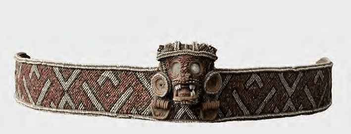
deceased stood out. Far away, in the distant Caribbean, some of the most
elaborate and precious precolonial duhos or stools once featured gold-encrusted
mouths. While only one specimen with the gold still intact survives, one
wonders if the Taino practice of inserting gold into the mouth of zoomorphic or
anthropomorphic faces of duhos could possibly be a remnant of a similar
practice with the burial customs of some South American Indians? Instead of
doing it for the dead, however, the Taino practiced the same custom for duhos,
whose carved faces must have had some religious and spiritual connotations due
to the use of duhos for cohoba ceremonies.
Account of the Fables and
Rites of the Incas
The translation of
Cristobal de Molina's Account of the Fables and Rites of the
Incas provides more interesting information on Inca rites and
religious practices. Molina wrote his account based on interviews with elders
in Cuzco, who recalled the customs of the empire in its later years. Since
Molina was as a priest in Cuzco and master of the Quechua language, he was able
to accomplish this. Of course, an immediate problem arises with this work.
While he may have been fluent in the Quechua language, the fact that he was a
priest and his main informants only represented the elite, does suggest that
some omissions and bias likely influenced this short account of Inca religion
and rites. Nonetheless, de Molina's expertise in indigenous languages and the
fact that his description of, for example, rites like the initiation of young
adult males can be corroborated elsewhere make him a reliable source.
For our purposes,
however, the main interest in de Molina's description of Inca religion is some
of the connections we see with other parts of South America, including
Amazonian areas. Like other accounts of origin myths, one sees parallels with
other Amerindian peoples through archetypes, such as origins in a cave
(Tambotoco at Pacaritambo). Like the Taino origin myths recorded by Pane, some
people were also turned into stone. During the puma skin dance, Incas inserted
gold into the heads of dead pumas that were worn. This recalls our past
fanciful notion of a possible South American connection with the gold encrusted
mouths of duhos from pre-Hispanic Hispaniola. The author, de Molina, also
refers to healing practices and ritual fasts, something we have already noticed
may have connections with other South American shamanistic practices and
medicinal practices. Furthermore, the Inca ritual calendar and its link to
imperial expansion may be illustrative of similar spread of cemis in the
precolonial Antilles, at least in areas where some caciques were able to
dominate several others. Naturally, the Inca state, far more expansive and
centralized, developed this to a much greater extent. For example, the
Capacocha sacrifices, which took place across an empire and were recorded with
quipus, undoubtedly reflected the greater centralization of power and ritual in
the Andes.
Last but certainly not
least, de Molina's brief description of the Taqui Onqoy millenarian movement
warrants attention. Although he erroneously connected it with the last bastion
of Inca resistance at Vilcabamba, the movement appears to have arisen
independently. Moreover, it represented a shift in the tradition of the huacas,
who now possessed Indians and urged them to fight and eradicate the Spanish.
While in some ways a restorationist movement that threatened the colonial
system, this novelty of spirit possession by the huacas raises several
interesting questions. Was it due to the radical shift and demographic collapse
caused by colonialism? Or, perhaps, was the belief in spirit possession by the
huacas also influenced by European and African beliefs? This seems unlikely,
but something we would like to pursue.
Bernabe Cobo and the
Incas
Bernabe Cobo's History
of the Inca Empire, translated by Roland Hamilton, includes an introduction
by Rowe praising the author. According to Rowe and Hamilton, the Jesuit Cobo,
though writing in the 17th century and mainly relying on older chronicles,
exhibited greater discernment and judgment in his interpretation of the
sources. In addition, Cobo also lived for several years in Peru and was able to
personally witness the ruins of Inca buildings and discuss related matters with
Cuzco informants, such as Alonso, a grandson of Guayna Capac. The longevity of
his stay in Peru and his access to several earlier chronicles, including some
which have not survived, make Cobo one of the great synthesizers of the Spanish
chronicle historiography on the Incas. However, he seems to have especially
relied on Polo de Ondegardo.
However, the first part
of the text is mainly about the indigenous peoples of the Americas, including
lengthy sections on why Peru was not Ophir and why the ancient Hebrews were not
the populators of the Americas. Furthermore, Cobo spent several pages
describing the allegedly barbaric and backwards customs of the Indians, clearly
reflecting a colonialist and Catholic perspective on the Indians. To his
credit, despite the alleged similarities across the entirety of the Americas in
terms of barbaric customs and similar features, Cobo at least acknowledged 3 distinct
types of Indian communities or polities. Those of the behetrias lived without
caciques, those of an intermediate level who did possess caciques and some
degree of political centralization beyond a community level (like our Indians
of Hispaniola and the nearby Antilles), and then the third stage, achieved by
the Aztecs, Incas, and the Muiscas. However, these last three, despite their
superior stage of civilization, remained barbarians.
Part of Cobo's
colonialist and anti-Indian bias also appears near the end of his description
of the Inca rulers, portraying their reign as one of pure tyranny and unceasing
exploitation of their subjects. The Inca ruling class, according to Cobo,
prevented their subjects from owning their own land or possessions, imposed
heavy labor tribute obligations, imposed heavier punishments for commoners,
seized children for sacrifices to the huacas, and otherwise oppressed their
subjects to be even more oppressive than the colonial regime. Cobo also
admitted that the Inca rulers tried to ensure their subjects were able to live
at least at a subsistence level and that their practice of relocating communities
to new provinces usually aimed at resettling them in areas with similar
environments. Nonetheless, Cobo's colonial and Christian biases perhaps forced
him to portray the Incas as despots and cruel pagans. Fortunately, it did not
prevent him from occasionally expressing admiration for their achievements in
other fields. Architecture, textiles, mining, the accuracy of khipu records,
the effectiveness of Inca postal services and roads, and the rulers' successes
in creating an orderly system across a huge swath of South America warranted
praise from the biased Cobo.
What is particularly
useful in Cobo's relatively scientific or rationalist approach to the study of
Inca history is his judicious judgment of Inca history. According to him, the
history of the Incas (and most Indians) probably reached back no further than
around 400 years. And unlike El Inca Garcilaso, Cobo did not claim that all
Inca rulers married their sisters, a custom which more likely arose among later
kings, beginning with Tupa Inca Yupanqui. Moreover, Cobo's account includes
references to several moments of rebellions and conflict within the Inca
aristocracy. For example, conflict between the ruler and "bastard"
brothers over the throne occurred more often than El Inca Garcilaso indicated.
The greater ruler Pachacutic, for instance, had to have a brother, Inca Urco,
murdered for trying to rebel. Huayna Capac also had to defeat a usurper
supported by his uncle, Gualpaya. Even more disastrous, the conflict between
Atahualpa and Huascar for the throne involved military leaders who had
participated in the conquest of the Quito provinces aligning themselves with
the former. They believed Huascar, ruling from Cuzco, would have favored others
over them and therefore offered their greater military experience to Atahualpa.
In other words, conflict over the throne and internal discord were present
among the Inca elites. Unsurprisingly, the Inca empire's instability was
therefore a consistent problem. Imposing the worship of the Sun, Cuzco huacas
and the incorporation of the huacas of other regions into the Cuzco-centered
pantheon must have consolidated this sociopolitical system in which the
administration was based on the labor tribute, or mita, of commoners while
using curacas and others appointed to office or recognized by the Inca.
Unfortunately, the intricate details of moments of threat to this order are not
always clear, besides pivotal moments like the Chanca rebellion that nearly
took Cuzco.
As for the Incas and an
ongoing obsession with the Taino, one sees more possible commonalities. The
Taino cacicagzos perhaps shared a similar revenue system, one in which subjects
were expected to provide labor for caciques. Like the Peruvian example, the
Spanish likely adopted or adapted aspects of this precolonial structure into
the colonial encomienda system. The two also shared the similar practice of the
rulers exchanging or gifting women, since the Inca was said to have gifted
maidens to favorites or those who performed wondrous feats. Human sacrifice
among the Taino has not been incontrovertibly proven, but both Tainos and Incas
shared a similar veneration of the bones of ancestors. For the Taino, human
bones and crania could become cemis. Cobo also wrote of mummies of Inca rulers
which had eyes made of thin golden cloth, such as that of Pachacutic. One
wonders if this may have a similar connection with gold-encrusted eyes in duhos
of Hispaniola. Last, but certainly not least, the use of duhos, a word not used
by Peruvians, was an important symbol of chiefly authority. Indeed, the Inca
gave duhos to caciques appointed by him. Just as duhos were symbols of chiefly
power among the Taino, the Inca and caciques or curacas in Peru also used
similar stools.
Inca Religion and
Customs continues Bernabe Cobo's work on the Inca
Empire. Instead of history, however, the author emphasizes religion, customs,
rites, superstitions, and everyday life among Peruvian Indians. Those who have
read El Inca Garcilaso and other sources on life in the Inca Empire will be familiar
with much of the information reported here. However, since Cobo relied heavily
on a lost work by Polo de Ondegardo, plus his own observations and travels
across Peru, one occasionally finds gems of information or additional
references to further research. For instance, some ideas of the role of
constellations in Inca cosmology and understanding of the origins of humans and
animals are clear here. In addition, a detailed list of several guacas and the
types of service or tribute and sacrifice they received helps one comprehend
the tight relationship between the guacas and the Inca state. One can even find
a functionalist and rational explanation for the practices of sorcery,
divination and magic among the elderly in Inca society since, according to Cobo,
elderly men had no other source of living except selling or exchanging their
spiritual or magical services. Furthermore, Cobo mentions juntas or convitas
among the farmers of the empire, the monopolization of the services of
specialized artisans by the Inca and caciques, and the accomplishments of the
pre-colonial Peruvians in architecture, weaving, agriculture, infrastructure,
and metallurgy.
Sarmiento de Gamboa and Writing Inca History
Pedro Sarmiento de
Gamboa's 1572 chronicle of the Inca Empire, The History of the
Incas, is one of the more fascinating early Spanish colonial histories
of the Incas. While undoubtedly a product of Francisco de Toledo's vision for
the colony and Sarmiento de Gamboa's pro-colonial outlook that aimed to
delegitimize the Incas as tyrannical despots, the chronicle was also based on
oral testimony and traditions from members of all the royal ayllu of Cuzco. Moreover,
Sarmiento de Gamboa had planned the chronicle to be the second of a three-part
work covering the viceroyalty, based on extensive travels around the colony. His
chronicle even included the names of various Cuzco Indian witnesses who were
present for a reading of the work and whose commentary on it was incorporated
into the text. That said, Francisco de Toledo and the colonial officials likely
exerted pressure on the Cuzco indigenous informants. And since the actual
testimonies collected by Sarmiento de Gamboa appear to have been lost, it is
possible that the author changed or modified things or perhaps misunderstood some
of the oral traditions he heard. Due to the overriding goal of Sarmiento de
Gamboa to portray the Incas as tyrants and to legitimize Spanish possession of
Peru, this chronicle likely deviated from the perspective of the descendants of
the Incas.
Despite these
aforementioned problems with Sarmiento de Gamboa's work, and its problematic
chronology that places Manco Capac's death in 665, thereby distorting the
chronology of the Incas, he reports a number of interesting traditions and
accounts of the 12 Inca rulers. For instance, a detailed version of the Inca
origin myth from Pacaritambo and the days of Manco Capac that led to the
conquest of Cuzco from its native inhabitants is presented in a way that points
to internal conflict among the Inca and their alleged tyranny and despotism.
Surely this way of presenting the Incas, like that of the later work of Cobo,
may not have been the most faithful retelling of the myth. Sarmiento de
Gamboa's work also mentions historical details and an earlier tradition of Inca
history from the times of Pachacuti. It is possible that Sarmiento de Gamboa’s
work, and the painted cloth that similarly reproduced the history of the Incas,
were based largely on the painted boards and the collected historical
narratives produced after Pachacuti gathered elder historians from across the
provinces to Cuzco. Pachacuti, as such a prominent ruler and pivotal figure in
the Inca state's expansion, probably helped consolidate and organize an
"official" history of the Incas that drew from oral traditions and
quipu. While the oral traditions kept by members of the royal ayllu were
naturally major sources to Sarmiento de Gamboa, the Cuzco royal ayllus would
not have escaped the influence of Pachacuti's historical investigations.
Unfortunately, since none of the painted boards Pachacuti had designed have
survived, one cannot ascertain further details of this.
Besides reporting a
number of traditions and sometimes conflicting accounts of the reigns,
rebellions, achievements, and conflicts of the Incas, Sarmiento de Gamboa
recorded a fascinating tradition of an Inca's travels in the Pacific Ocean
after the conquest of Quito. In short, Pedro Sarmiento de Gamboa's account of Topa
Inca's Pacific expedition to the islands of Avachumbi and Ninachumbi was based
on an account given to him by Urco Guaranga, an important Inca who was one of
the Inca elite informants of Sarmiento's chronicle. Apparently Urco Guaranga
also owned the skin and jawbone of the horse brought back from the Pacific
island by Topa Inca. Additionally, Urco Guaranga also named several of the
prominent Inca who accompanied Topa Inca on their expedition into the Pacific.
Sarmiento is sure that the islands visited by Topa Inca must have been the ones
he "discovered" in 1567, about 200 leagues west of Lima (the Solomon
Islands). But something does not add up. If Topa Inca had really visited the
Solomon Islands after his conquest of Quito, how could he have brought back the
skin and jawbone of a horse? There were no horses in the Solomon Islands or
Polynesia during the 1400s, right?
But the account does seem
to describe something that occurred before Topa Inca became emperor. During the
conquest of Quito or Ecuador, merchants who traveled across the Pacific with
sailboats described their island homeland as possessing gold and Topa Inca,
after using the supernatural abilities of Antarqui, confirmed the story of the
merchants. Then he traveled with 20,000 soldiers on rafts into the Pacific,
disappearing for at least 9 months. However, when Topa Inca returned, he
brought "black" men, a brass chair, and the previously mentioned skin
and bone of a horse. If all this truly occurred, as seems likely, the coast of
Ecuador was in contact with traders from the Pacific (somewhere in Oceania) and
these islanders included "black" people (Melanesians?) with access to
brass and a "horse." If the horse parts were those of some other type
of animal, which seems likely, and the Polynesian sailors were from a part of
Polynesia which engaged in a trade of gold, metals (brass?) and other goods
with the coast of Ecuador, this is probably evidence of transoceanic trade
contacts between South America and Polynesia in pre-Columbian times. Contacts between
coastal Ecuador and/or Colombia with Polynesian people has been proposed based
on genetic evidence, so it is certainly plausible that an Inca prince could
have journeyed to Polynesia after meeting said merchants.
Ultimately, however,
Sarmiento de Gamboa wished to portray the Incas as illegitimate rulers and
oppressors of the Indians of Peru. The tale that began with Manco Capac having
a brother killed and the Incas usurping Cuzco ends with the fratricidal war and
massacres of Huascar and Atahualpa. As admitted by Sarmiento de Gamboa, Pizarro
and the Spaniards were only able to defeat the Incas because of the war between
Atahualpa and Huascar that had decimated the empire and led to divisions within
the ruling elite. Moreover, Inca expansion from Pachacuti to Huayna Capac
relied on, to his eyes, oppressive and extreme exploitation, excessive taxation,
and control of the conquered Indians. They didn't even respect their own
customs when dealing with their kin and fellow Incas. Thus, such a tyrannical dynasty
that was only able to control its subjects through extreme brutality, was
wholly illegitimate and the Spanish were morally justified to replace them.
Despite Sarmiento de Gamboa's obvious bias here, one can read between the lines
and detect how imperial overexpansion and an unstable system of succession
perhaps led to the Inca Empire's rapid dissolution.
Juan de Betanzos’s Narrative
Juan de Betanzos's Narrative
of the Incas is yet another chronicle by a Spaniard on the history of
the Inca Empire. The advantage of this chronicle is that it was composed in the
1550s and its author was married to a woman who was a mistress of Pizarro and a
wife to Atahualpa. Through her and her elite Inca relatives and connections,
Betanzos undoubtedly received many traditions and narratives of the past of the
Inca Empire. By and large, he provides what became the standard account of Inca
origins beginning with Pacaritambo and the early Inca kings or rulers. If one
reads between the lines, there may be a story of conflict among the 4 brothers
and their wives who left Pacaritambo. One of them, Ayar Cache, was tricked into
returning to the cave and trapped. He has less to say on the period preceding
Pachacuti and that final century of imperial expansion. Basically, Pachacuti
established the greatest aspects of Inca civilization, laws and urban planning
in Cuzco and beyond. Indeed, Betanzos credited him with rebuilding Cuzco, setting
up storehouses, building the Temple of the Sun, and probably with the practice
of reciting narrative poems on the exploits of past Inca rulers at their
statues. His role in the creation of an Empire after the defeat of the Chancas was
undoubtedly idealized. According to Betanzos's informants, Pachacuti was so
great that he applied the laws equally to nobles and commoners alike.
The rest of the first
part of the chronicle covers the conquest of Quito, wars and conflicts against
rebel provinces or peoples, the Andesuyo campaign against Amazonian peoples,
and Pachacuti's prediction of the Spanish conquest after the reign of Huayna
Capac. The ethnographic details reported in the Andesuyo campaign are
fascinating since the description of its people reveals similar customs with
those of indigenous people in the Caribbean (storing the bones of deceased
relatives on the top of the wall of one's home). Perhaps the Incas also saw the
"naked" Amazonians as savage, too, since they were reported to be
lazy cannibals. Yet from their region gold dust, jaguars, parrots, amaro snakes
and Amazonian people were brought to Cuzco. One may wonder if Guaman Poma de
Ayala's reference to an Inca ruler who could transform into a jaguar was a
reference to the brother of Topa Inca Yupanque. According to Juan de Betanzos,
this brother was famous for killing a jaguar and then actually ate Amazonian
enemies after their rebellion. Maybe there was a mystical or shamanistic belief
that this historical figure, Inca Achache, “became” a jaguar when he killed or ate
enemies. And somehow Guaman Poma mixed him up with his brother? This leads one
to think about the subtle changes in the portrayal of the Incas in the
different oral traditions.
The rest of the chronicle
covers the conflict between Huascar and Atahualpa and the Spanish conquest.
Perhaps due to the bias of his wife, who was in Atahualpa's camp, Huascar is
portrayed as an alcoholic and incompetent ruler who triggered the disastrous
war with his half-brother. Atahualpa, also apparently drunk at inopportune
times, was more skilled and had excellent generals and warriors that defeated
Huascar. The Spanish, unsurprisingly, benefited from the confusion caused by
the belief of some that they were Viracochas and the recent war between
Atahualpa and Huascar. The long, murderous section on this violent end of the
empire largely ignores the conflict between Pizarro and Almagro but ends while
describing the Vilcabamba Incas. Sadly, a black woman of Diego Mendez, who
warned the Inca that his Spanish allies were about to betray him, was killed
after the assassination of the Inca. Overall, some of Betanzos's account of
this period is difficult to follow and certainly reflects the bias of his
informants. But it is interesting to think about what would have happened if
Atahualpa had not been captured by Pizarro. Would he have finished the move of
the capital from Cuzco to Quito? Would the war-torn empire have been able to
recover and survive longer into the 16th century?
Polo de Ondegardo’s Report
The unfortunately brief
report of Polo de Ondegardo, included in Markham's Narratives of the
Rites and Laws of the Yncas in a probably problematic translation, is
an interesting read on the Inca Empire and colonial Peru. Written by one who
had traveled and received help from close observation of Inca records (quipu),
monuments, shrines and traditions, Polo de Ondegardo's report and lost writings
must have been a major source of information for later Spanish chroniclers.
While too brief to offer a full breakdown on the Incas, de Ondegardo reasonably
placed the origin of the Incas back 350-400 years before his time. Relying on
their memory of their history as preserved in their quipus, he traced Inca
expansion to the successes of Pachacuti and his successors. Therefore, the wars
of expansion of the Incas were recorded in the registers of the Incas, presumably
the quipu. Unique in this work is the allusion to the mother of Pachacuti. In
Polo de Ondegardo's retelling, Pachacuti's mother had a dream in which the first
success of the Chancas against the Incas was due to the Incas showing greater
veneration to the Sun than the universal Creator. Thus, in this version of that
pivotal moment in Inca history, Pachacuti's mother was important for her dream
which led to the Incas showing greater dedication to the Creator.
The rest of the brief
report offers several observations on the Inca system of taxation, tribute,
land ownership in ayllus, and the administrative success of the state. Polo de
Ondegardo clearly was describing these things since the Spanish Crown succeeded
the Incas as the legitimate rulers of Peru, and borrowing from the Inca system
offered a model for creating an orderly colonial system. Instead of, say,
taxation that ignored the precolonial system, which led to an unjust burden,
following the Inca practice could pave the way for a more stable colony.
Indeed, the Inca system of tribute was, in some ways, less onerous and more
favorable to the common good. In fact, those who worked the land for the
service of religion or the Inca, ate and drank at the cost of the Inca. Finally,
the impressive efficiency of the Inca postal system and their custom of
preserving forests, hunting grounds, and protecting the population of their
livestock all seemed like excellent practices the Spanish should adopt. One
cannot help but detect some admiration for the Inca when de Ondegardo reports
that the Incas sometimes received fish from the coast of Tumbez via their roads
and postal system. And to do so without horses but only a system of
runners and yet remain more efficient than the system implemented by the
Spanish!
An Elite Indigenous Christian View
Although far shorter and featuring cruder
artwork, Juan de Santa Cruz Pachacuti-Yamqui Salcamayhua's "An Account of
The Antiquities of Peru" is a fascinating historical source on the Incas.
Written from the perspective of an elite Indian Christian, it offers an
interesting perspective on the precolonial past with some similarities and
differences from Guaman Poma's more detailed chronicle. Unlike Guaman Poma,
there is no sign that this Indian writer had an obvious political motive for
writing his brief account, except perhaps as a Christianized indigenous
perspective on the rise and fall of the Incas. But the author's Christianity
profoundly shaped and perhaps distorted the history of the Incas who, at
various times, were presented as opponents to the huacas, idolatry and demons that
had plunged Peru into heathenism before the Spanish conquest.
Implausibly, our
chronicler believed Viracocha may have been St. Thomas, the apostle, an idea
also found in Guaman Poma's work. According to this Christianized
interpretation of Viracocha, the apostle promoted the worship of the Creator or
universal Creator while opposing idolatry and the worship of huacas throughout
Peru. This Tonapa, another name reported for this figure Juan de Santa Cruz
merged with St. Thomas, was given a significant role in the origin of the Incas.
After all, it was his staff that was
inherited by Manco Capac. In other words, the Incas were, early on, at least,
exposed to some ideas of a single God or Creator. The chronicler, however,
appears to consistently mistake the worship of the Sun with the worship of the
Creator, causing many problems in his portrayal of this or that Inca ruler as
an enemy to the huacas. Nonetheless, some of his reports of Incas opposed to
huacas from one province or another may reflect historical moments in which the
religious policy of the Inca state opposed those of other peoples or provinces.
Other moments in the lives of the Inca seem a little questionable or perhaps of
Biblical inspiration. For instance, the report of Manco Capac sacrificing his
son to receive a sign from the Creator bears an uncanny resemblance to the
Judeo-Christian Abraham.
Overall, this brief account provides the usual overview of the lives and deeds of the Incas, with some occasionally rich detail, report of a miracle or exceptional event. The Incas were occasionally corrupt and unjust, abusing, exploiting and promoting idolatry. Others, however, established good laws and supported the worship of the Creator. By the end of the Empire, Huascar, portrayed as more sinful and incompetent than Atahualpa, is presented as so corrupt as to allow men to have their way with the virgins in the square of Cuzco. The Spanish conquest, therefore, helps to reestablish monotheism and the "true faith" as the "Viracochas" return with the Bible. Perhaps the believe that Tonapa was St. Thomas was a way to reconcile the brutal shock of two different worlds when Pizarro arrived? By accepting Christianity, they were just returning to the ways of Tonapa that they had deviated from under the Incas. Does this also help to understand what the sources indicated when they claimed Tonapa carried a book with him during his travels? Was this mysterious "book" in precolonial Peru a reference to what they would later know as the Bible? Or some other type of holy text and writing besides the usual records in khipu?
Fernando de Montesinos and the Question of Early Inca (Peruvian) History
Fernando de Montesinos’s Memoriales
antiguas historiales del Peru is a tricky source. The manuscript
translated by Philip Ainsworth Means includes a critical introduction by
Clements R. Markham indicating that the chronicle was likely based on a lost
text by the Jesuit mestizo, Blas Valera. However, Montesinos endeavored to
force the long history of Peru into a Christian timeline based on the arrival
of Noah's son, Ophir, in Peru and reckoning years by 1000-year periods since
the Flood. It also appears that Montesinos frequently confused ancient,
pre-Inca kings with those better known from other sources on the Inca period.
Nonetheless, despite the clearly legendary character of many of the pre-Inca
kings and the problems with the chronology suggested by Montesinos, his work is
an invaluable source on how, filtered through his own bias, the amautas and
quipucamayocs possibly conceived the ancient history of Peru. Furthermore, the
idea of the Incas rendering time through cycles with new suns in which, after
every 500 years or so, a Pachacuti reigned, is a fascinating one that could
point to Mesoamerican influences. Alas, the more reliable work of Blas Valera
is lost, forcing us to make sense of the Montesino's work with what has
survived from various other Spanish chroniclers, Garcilaso de la Vega and
Guaman Poma de Ayala.
In some respects, the
chronicle is mainly an extensive list of names with some receiving detailed
attention on events during their reigns. This recalls sources like the Diwan of
the Sayfawa in Kanem-Borno. Like this African dynasty, several critical
questions have arisen about the chronology used, the possibility of telescoping
or confusion, the inclusion of early kings who are of a more legendary
character, and the function of such long lists. Sadly, unlike Kanem-Borno, we
lack written sources from the pre-conquest period that corroborate it. But, following
the chronicle of Guaman Poma de Ayala, one can also see how a chronicle written
as a lengthy list would be likely based on oral traditions preserving history
through songs and genealogies while also, perhaps, reflecting the use of
quipus. Verily, Montesinos himself said this, as he claimed amautas and quipus
were the sources of his chronicle. However, unlike any other source, this is
the only one that delves deeply into the matter of pre-Inca kings, before the
Inca state of Cuzco developed into a powerful empire that dominated Peru and
surrounding areas. It even alludes to migrations and invasions from the
Amazonian region and north that, if even remotely true, show how well-connected
Peru was to other parts of South America.
Were some of these
pre-Inca kings, also said to have been based in Cuzco and of the same origin as
the Incas in other creation myths recorded in the chronicles, references to
Wari and Tiwanaku kings? Why were they then later remembered as kings based in
Cuzco? Was this simply an example of Inca-period amautas transforming the past
in a way that affirmed the ultimate Inca authority over Peru based on
antiquity? Or was this a reflection of a cyclical view of the past, with similarly
named kings assuming to have ruled over various periods of greatness and
decline for thousands of years? Undoubtedly, the chronology used here reminds
one of that used by Guaman Poma de Ayala, who, instead of multiplying the
number of kings, extended the reigns and lifespans of the Inca emperors and
rulers back to about 2000 years ago. However, the traditions recorded by
Montesinos allude to interesting events that, while perhaps mainly of an
apocryphal character, include a loss system of ancient writing, wars and
migrations with people from the East and North and across the sea (including
"black" people in their ranks), and the earlier expansion of the
Peruvian kings into Quito. Again, Montesinos confuses some of these earlier
kings and their exploits with the better known (and significantly later) Inca
period of imperial expansion, but perhaps these tales reflect earlier Tiwanaku,
Wari, and Chimu states.
Ultimately, we are of the
view that the exhausting list of 93 kings or more of Peru likely does reflect
earlier periods in which Wari and Tiwanaku were major powers in the region. The
extended chronology and the possibility of collateral succession probably
indicate that the extended chronology of Montesinos is far too long.
Nonetheless, some of the details reported here are fascinating though difficult
or impossible to prove. The idea of the ancient Peruvians having a system of
writing using parchment and leaves is fascinating, especially since other traditions
about Viracocha (sometimes confused with St. Thomas the Apostle) mention him
carrying a book. Whether or not it was true that an oracle demanded they cease
the use of this writing system seems more legendary, but it would suggest that
the Incas developed quipus (including the phonetic ones) from an earlier system
based on a writing script. Why Guaman Poma's sources did not include this
extensive list of pre-Inca kings may have also reflected his dissimilar sources,
not based in Ecuador, as well as the influence of Christianity on his
conception of time. Perhaps thinking of the Biblical stories and Christian
traditions of long-lived patriarchs and the way other traditions in Peru
stretched out the chronology of Inca rulers, Guaman Poma instead followed the
traditional list of Inca-period rulers based at Cuzco while attempting to
preserve the longer time period with inexplicably long reigns. Guaman Poma then
was freed from the long list of others who, to be even somewhat accurate for
the pre-Inca period, must have been referring to Wari and Tiwanaku rulers
whilst forcing that earlier period into a history of the Cuzco-based kings.
Pedro de Cieza de Leon and the Incas
Completing The
Incas, Harriet de Onis's translation of Pedro de Cieza de Leon was a
time-consuming endeavor. Translating parts of different books of Cieza de
Leon's history of Peru, the text is somewhat disjointed and a jarring.
Nonetheless, it is a major source as one of the early chronicles on the Incas
written by someone who traveled widely across South America. Moreover, he also
had access to some of the early conquistadors and Spaniards who came to Peru
with Pizarro or during the 1540s. This means that Cieza de Leon had access to dependable
informants, as well as indigenous informants or ruins he saw throughout his
travels. Even more intriguing is the degree to which the author admired the
achievements of Inca civilization in terms of its roads, architecture,
administrative efficiency and economic organization. The Spaniards, particularly
during the course of the civil wars after the conquest, were seen as the major
ruin of the Indians, particularly in many coastal areas and valleys where the
indigenous population was decimated by the Spaniards.
As a major source on the
Inca Empire, much of the text is spent describing the various provinces and
regions under the control of Tawantinsuyu. The northernmost area of conquest,
Pasto, was seen by the Incas sent there as a way of time. But Ecuador and much
of the modern-day areas of Peru and Bolivia were described in detail. Though
some of Cieza de Leon's sources were muddled or confused, he alluded to various
provinces and under which Inca they were added to the empire. Some areas were
remembered for the defeat of the Incas, such as Huayna Capac's failure to
conquer the natives of Bracamoros. According to Cieza de Leon, one Inca ruler,
Yahuar Huacac Inca, was killed or assassinated by Cuntisuyu captains to prevent
him from making further conquests. Inca Urco, the son of Viracocha Inca and
thus a brother of Pachacuti, is described as a corrupt, ineffective ruler who
was later replaced by Pachacuti. Strangely, however, the story of Pachacuti's
victory against the Chancas did not feature stones turning into soldiers.
Intriguingly, our chronicler also alluded to moments of revolts and coups by
Cuzco elites, such as one crushed by Huayna Capac and another. One also finds a
few more references to unrest in the provinces, such as a revolt by the Colla
Indians against Pachacuti while the latter was in the East.
Surprisingly, despite his
detailed account of the regions of Ecuador under Inca rule, one does not find
any reference to the Pacific Islands visited by Topa Inca. Instead, islanders
bringing gold were said to have visited the southern coast of Peru at Acari.
The Puna Islanders, however, were described as traders and pirates. As for the
eastern lands, or Amazonian regions, Cieza de Leon makes an interesting
reference to orejones disguised as traders to the East. Paititi, the mysterious
land somewhere in the East, is also mentioned. One cannot escape reading this
chronicle without noting Cieza de Leon's admiration for the Incas and even his
respect for indigenous peoples (despite his constant lamentation of their
demons and superstitions). His ability to note the deeper antiquity of the pre-Inca
civilizations is also noteworthy.
Miguel Cabello de Balboa and Incas in the Pacific
Although this is far from
ideal, one can get the gist of Miguel Cabello de Balboa's chronicle of the
Incas in a 19th century French
translation. Completed by Ternaux Compans in the
1840s, the partial translation covers the chapters pertinent to the Incas,
omitting most of the large chronicle's chapters on various other topics.
Obviously, we would prefer to read the entire work. But reading 16th century
Spanish chronicles is harder than 19th century French translations. Despite
this less-than-ideal context for reading Cabello de Balboa, one is struck by
some of the differences in how this chronicler approached the past of the
Incas.
First, Miguel Cabello de
Balboa drew from a lost work by Cristobal de Molina and his own sources. Some
of these sources seem to reflect greater familiarity with the coastal regions
of Peru and Ecuador rather than Cuzco. This means that Miscelánea
Antártica may be useful for reconstructing the general narrative of
Inca history written by Molina. It also adds a little more knowledge of the
Chimu, Lambayeque and other coastal or plain areas, including stories and
traditions of the rotation of rulers in the Lambayeque valley and what happened
to descendants of the ruling class there. Alas, we do not have anything akin to
a detailed chronicle of Chimu or the coastal dynasties, but it shows how the
power emanating from the coast grew at the same time as that of the Incas in
Cuzco. Migration to and from between the coast and the highlands has also been
a recurring factor that must have affected the relationship between yungas and
highlanders in many ways not explored in this chronicle.
Even in his account of
the rise of the Inca rulers at Cuzco, Cabello de Balboa differed from others.
The early Inca rulers, as one might surmise, left Pacaritambo but it took
generations before their power was felt beyond the Cuzco valley. With the rise
of Pachacuti, the empire truly took shape. Hailed as a reformer, conqueror,
able administrator, and the man who dethroned his father, our chronicler
confused him for his son, Topa Inca. The familiar story of the rise of the
Incas under these two into a formidable empire is here, but one gets a sense of
just how unstable things could be with the rapid growth of empire. For
instance, a plot against Topa Inca by his brother, Topa Capac, threatened the
former's reign. Succession crises were also common, as Topa Inca was said to
have preferred his illegitimate son, Capac Guari, to succeed. However, Huayna
Capac and his mother resisted this move and went as far as to accuse the mother
of the bastard heir of poisoning Topa Inca! Even regents could be a threat to
young rulers, as Huayna Capac's regent, Apoc-Gualpaya, sought to seize the
throne from him, too! Even during his campaigns against the Caranguis, the orejones
warriors revolted due to their poor treatment by Huayna Capac after their
shameful retreat. It required the miraculous story of the mother of Huayna
Capac's speech and intervention (plus generous gifts and supplies of food from
Huayna Capac) to restore the loyalty of orejon troops. One might add
that these were troops from Cuzco, too, not warriors gathered from the
provinces. Considering the fratricidal conflict between Atahualpa and Huascar
on the eve of the Spanish conquest, it was perhaps quite common for conflict
over succession or the throne to occur in a context where the Empire grew so
rapidly over a short century.
The rest of Cabello
Balboa's observations on the Incas are occasionally interesting. Thrusting a
love story here or there, for example, might be an example of how his Inca
informants combined engaging personal narratives with history. He also was extremely
negative in his evaluation of Huascar. The latter is depicted as a brutal
tyrant without any real military leadership ability. Atahualpa, on the other
hand, gives a stirring speech in which he justifies his conflict over the
throne as a defense of the rights of his supporters. Atahualpa's troops
committed atrocities too, yet Cabello de Balboa's chronicle (or his sources)
appear to have been pro-Atahualpa. Some of the other observations made in the
chronicle are a reference to the use of khipu to "record" a will (the
testament of Huayna Capac) and the maritime voyages of Topa Inca to two
mysterious islands in the Pacific.
Acosta’s Synthesis
Reading Jose de
Acosta's Natural and Moral History of the Indies for a deep
chronicle of the Inca Empire is bound to disappoint. Acosta's work, which
focuses on the Americas in general (though Acosta had traveled to other parts
of the Americas like Santo Domingo), synthesized older accounts of the Inca
past, particularly the works of Polo de Ondegardo. Consequently, his account of
the Inca past is derivative and, besides references to the flora, fauna, and
superstitions of Indians in Peru, adds little. In some respects, his coverage
of the Inca and Aztec Empires emphasizes how these peoples, deceived by Satan
from Acosta's Jesuit perspective, built impressive civilizations that paved the
way for Christianity to spread. Thus, unlike the indigenous peoples of Brazil
or other parts of the Americas which lacked large kingdoms or polities, the
Incas and Aztecs promoted religious cults that, like ancient Rome, eased the
spread of Christianity through the state's institutions and influence across a
vast territory.
Acosta's perspective also
reminded us of Edward Blyden's views on Islam in West Africa, which he
similarly praised while also expressing the belief that Islam will prepare the
path for the Christianization of black Africans. This is undoubtedly part of
the reason Blyden could write positively about Islamic cultures or societies in
West Africa yet still believe Christianity was soon to succeed Islam in lifting
the region. But to return to Acosta as a chronicler of the Incas, this does not
offer much. Acosta shifts between condemnation of the Incas and admiration, and
there are interesting moments of comparative ethnology of the various peoples
of the America (and East Asia). But we hope to read another cronista with
a more substantial narrative of the Inca past. And really, 1000 people
sacrificed to accompany the dead Huayna Capac?
Extirpating Idolatry in Colonial Peru:
Religion and History
Pablo Joseph de
Arriaga's The Extirpation of Idolatry in Peru is a fascinating
report on the widespread maintenance of precolonial religious traditions and
spirituality among indigenous peoples in colonial Peru. A Jesuit priest who
promoted "visits" by priests to identify huacas, "sorcerers"
and practitioners or observers of the pre-Christian faith, in order to destroy
relics, mummies, huacas, and force "sorcerers" and those who still
consulted them to cease, Arriaga is an important source on the nature of Andean
indigenous religion and spirituality. For instance, one chapter provides a
wealth of detail about the sorcerers or witches who plagued a coastal
community, gathering at night to kill their victims through supernatural means.
Supposedly, this league of witches honored a "lion" deity.
Much of the text also describes
other aspects of Andean religion, particularly the veneration accorded to
huacas, mummified ancestors, and household gods or clan-affiliated gods and
myths of origin. This information was considered particularly important for the
clergy operating in these areas so they could better refute the
"errors" of the Indians in the communities they served. Arriaga also
reserved criticism for the Spaniards and Church, which often failed to educate
the Indians about the fundamentals of the Catholic faith. They likewise did not
provide a good example to inculcate proper Christian values and practice.
Furthermore, far too few priests mastered indigenous languages like Quechua or
Aymara to give effective sermons or provide a fuller education to Indians about
the "true" religion that they had been exposed to since the Spanish
Conquest.
While modern readers
today might find much to lament or be disgusted by in Arriaga's account, it
nonetheless helps to identify some of the religious practices and traditions of
precolonial Peru. Unfortunately, we do not have more texts like the Huarochiri
Manuscript to shed fuller light on what must have been the incredibly detailed
and regionally specific traditions, legends, fables, and huacas of more areas
in colonial Peru. Arriaga's account on how the visits should work and the state
of Christianity among Indians in the early 1600s helps fill in the gaps.
Theater and the Inca Past
Markham's undoubtedly dated translation of Ollanta: An Ancient Ynca Drama from 1871 is an interesting read. Passionately believing that the play was preserved orally from precolonial times, probably during the reign of Topa Inca Yupanqui or Huayna Capac, Markham saw it as one of the few surviving theatrical works from the time of the Incas. In truth, we know from sources such as Garcilaso de la Vega and the eventual colonial suppression of it after Tupac Amaru's rebellion that theatrical works from and about the Inca past were preserved. Sadly, the version of Ollanta, here based on the surviving manuscripts written down in the 1700s and 1800s, appear to be a condensed or incomplete version. Inexplicably, ten years passed before the eventual reunion of the lovers Ollanta and Cusi Coyllur. The battles between the general sent by the Inca to defeat Ollanta after his revolt are quickly glossed over. One would think that the original narrative included more scenes or episodes for a fully fleshed story. The play also holds an implicit critique of Pachacuti for his excessive punishment of his daughter, yet the Inca is presented as the source of all moral authority and order. Why is it that his son, the Topa Inca Yupanqui, who eventually pardons Ollanta for his revolt in Antisuyu and promotes him to the highest rank, is presented as the complete opposite? Is the message here that the Incas were fallible? Lastly, did this signify that access to the higher ranks could be opened to those without aristocratic backgrounds if they proved their merit?
Friday, May 8, 2026
The Caribbean in the Islario of Alonso de Santa Cruz

Although not immediately useful for our primary interests, we found the maps of the insular Caribbean in Alonso de Santa Cruz's Islario general de todas las islas del mundo fascinating. We are primarily interested in indigenous toponyms in the Greater Antilles, for which the map of of Hispaniola is perhaps the most detailed or useful.


Wednesday, May 6, 2026
Towards an Art Historicization of Pre-Columbian Caribbean Archaeology
We really enjoyed this lecture by Lawrence Waldron on indigenous Caribbean art. Besides Arrom and Eugenio Fernandez Mendez, the only other author whose works we've read on "Taino" art and material culture is Ostapkowicz. We don't count Osvaldo García-Goyco's work here since his speculative attempt to link Taino art and symbolism with Mesoamerica was even less successful than Fernandez Mendez's work. Anyway, Waldron's approach here was really interesting, especially for noting continuity and change from Saladoid to Taino period ceramic arts.
Sunday, April 26, 2026
El Cacique Guariones
El cacique Guariones
defendió con patriotismo,
luchando con heroísmo
aunque falleció más tarde.
Borinquen vencida es
decía con aflicción
y con desesperación;
clamó nobles traidores
no caben vuestras labores
del árbol del corazón.
defendió con patriotismo,
luchando con heroísmo
aunque falleció más tarde.
Borinquen vencida es
decía con aflicción
y con desesperación;
clamó nobles traidores
no caben vuestras labores
del árbol del corazón.
The final part of a décima from Puerto Rico referring to a cacique named Guarionex and his resistance to the Spanish conquest. Unfortunately, J. Alden Mason and Aurelio M. Espinosa did not name the composer in their "Porto-Rican Folk-Lore. Décimas, Christmas Carols, Nursery Rhymes, and Other Songs."
Tuesday, April 14, 2026
Exploring Caizcimu, or Higüey Chiefdoms

Eastern part of Hispaniola (including Caizcimu and Higuey) from the 1517 Morales Map.
Higüey, or Caizcimu, the
eastern part of Hispaniola, represents another region which hosted a major
cacicazgo in the time of Columbus. But when one examines surviving documentary
evidence, the theory of a paramount chiefdom in eastern Hispaniola becomes much
weaker or ambiguous. Instead, as Alice Sampson has hinted, the peoples of
Caizcimu, the face of the island of Haiti or Quisqueya, may have been part of a
shifting network of chiefdoms which were not necessarily dominated by a single
one for long.[1]
This model is perhaps more appropriate for understanding how the societies in
eastern Hispaniola were organized before colonialism. Alternatively, the area
may have once been under the rule of a paramount cacique. But, at some point
early in their conflicts with the Spanish, this paramount chief, Cayacoa, died.
Succeeded by a wife, who later converted to Christianity, the area may have
reverted to a shifting network of alliances without one single cacique
paramount. In order to explore these theories, what follows will be our attempt
to trace the history of Higüey (or Caizcimu) over time using documentary
sources.
Spanish
Colonial-Era Sources
Naturally,
one must begin with the sources from the early colonial encounter, conquest,
and the rest of the sixteenth century. Beginning with Columbus, early Spanish
sources provide important glimpses of various aspects of indigenous societies
on the island. While few answer the types of questions we have today about the
origins and political organization of the indigenous peoples of the island, the
standard chronicles usually imply a powerful, paramount chiefdom existed in the
eastern part of the island. Some sources name it as Higüey, yet others, like
Oviedo, center it on Cayacoa, also called Agueibana.[2] The discrepancy on which
cacique in the east occupied a dominant position is not clear.
Furthermore, another
limitation is that our most detailed sources on the eastern tip of the island
are often centered on the two wars to “pacify” the region in the time of
Ovando. This means that they rarely provide historical context or background of
the region’s political landscape before the wars. Except for emphasizing the
leadership of Cotubanamá in these military campaigns, they cannot easily be
used to claim Cotubanamá was a paramount cacique of this region. In addition,
the later sources associated with the encomienda system in the 1514
Repartimiento name many caciques of the east. Depending on which chronicler one
prefers, Higuanamá, Higüey, or Cayacoa each appear on the list with large
numbers of indigenous followers assigned to different encomenderos in Santo Domingo, Higüey, or other towns. But from
this alone, one cannot easily presume which cacique was once the most powerful
before 1492.
Nonetheless, the 16th
century sources do provide some clues. One important chronicler, who never went
to the Americas but was well-positioned to read the works and speak with
travelers who did cross the Atlantic, was Peter Martyr d’Anghiera. Through him,
readers discover that the districts of Caizcimu, the eastern “face” of
Hispaniola, included Higüey, Guanama, Reyre, Xagua, Aramana, Arabo, Hazoa
(Azua), Macorix, Caicoa, Guiagua, Baguanimabo, and the mountains of Haiti
(Haitises). Springs of an exceptional character were in Iguanamá, Caiacoa and
Quatiaqua. Further, Caizcimu extended from the eastern point of the island to
the Ozama river.[3]
This information, derived in part from Andrés de Morales, whose excellent map
of the island drew from indigenous toponyms and references, establishes the
boundaries of Caizcimu. Within this much larger space, Higüey was just one
district or section of the island’s “face.”
Additional cronistas in the 1500s wrote about Higüey.
For Oviedo, perhaps one of the more racist and Hispanocentric writers of this
period, Cayacoa was the paramount cacique. Ruling from the Santo Domingo area
to Hayna River, and to the Yuma, Cayacoa died soon after the Christians warred
with him. Succeeded by his wife, Inés de Cayacoa who converted to Christianity,
Oviedo unfortunately did not elucidate further.[4] Nevertheless, Oviedo, who
came to the island several years after the “pacification” of the east, believed
Cayacoa was once the most powerful cacique in the region. With Higüey, his area
of influence extended to the mouth of the Yuma, this included Cotubanamá and
Higüey under his authority.
On the other hand, the
testimony of Las Casas, who arrived in the Indies earlier than Oviedo, contradicts
Oviedo’s understanding of the east. In his Historia
de las Indias, Las Casas specified that Cotubanamá’s settlement was near La
Saona island (although the indigenous pueblos were often located in the montes).
He also believed that Higuanamá was the king or cacique of Higüey, although he
expressed uncertainty regarding his memory.[5] Moreover, Las Casas
provided an overview of the 2 campaigns against Higüey, led by Juan de
Esquivel. Despite the first one ending with a guatiao between Esquivel (who later led the conquest of Jamaica)
and Cotubanamá, the second one ended with the demise of the latter.
Interestingly, the Spanish forces were accompanied by indigenous auxiliaries
from Ycayagua in the second campaign. This is yet another instance in which
political divisions and conflict between competing chiefdoms in the eastern
part of the island were implied. To what extent Ycayagua was opposed to
Cotubanamá or Higüey in precolonial times is unsure, but they clearly believed
it was in their interests to align with the Spanish against Cotubanamá.[6] Even more intriguing is
the long-distance ties to indigenous peoples in Puerto Rico, since they enjoyed
constant contact through canoes across the Mona Channel.[7] As the aforementioned name
of Agueybaná for Cayacoa makes clear, there may have been alliances with
indigenous peoples in Puerto Rico that shaped how different groups within
Caizcimu related to each other.
After the cronistas, some Spanish sources in the form of letters or records generated by or affiliated with the encomienda system provide some clues. For instance, one letter by Pedro de Cordoba, perhaps written in 1516, alluded to Higüey. Its importance as a source of casabe for Santo Domingo was highlighted. This correspondence also blamed Salamanca’s dog for the attack on a cacique which triggered one of the wars with Higüey. Likewise, the letters also allude to 1500 indios allegedly killed whilst 17 caciques hung in Higüey.[8] If true, then many caciques of the eastern part of Hispaniola were eliminated or removed in the early 1500s. This makes it even more arduous to attempt any reconstruction of Caizcimu’s political landscape based on the 1514 Repartimiento of Albuquerque. It nonetheless hints at an alliance of at least 17 caciques who joined forces with Cotubanamá against the Spanish in the second war of Higüey. Meanwhile, the 1517 Hieronymite Interrogatory clearly establishes a link between caciques in Higüey and those of Puerto Rico who had revolted against the Spanish in the 1510s. There a cacique named Andrés celebrated the victory of indigenous people in Borinquen whilst plotting to spread a revolt against the Spanish in Hispaniola.[9] This suggests, once again, the relevance of Puerto Rico to Higüey’s indigenous leadership in the past. With exchange, migration, and alliances being relevant factors in the area before 1492.
.png)
Map of eastern Hispaniola from 1566, showing Aguiebana near Santo Domingo (Gallica).
As for the 1514 Repartimiento,
multiple caciques with names linked to paramount status appear. Some even led
hundreds of followers, often split to serve different encomenderos in Santo Domingo, Salvaleón de Higüey and
other towns established by the Spanish. In Salvaleón de Higüey itself, Arranz Márquez’s
tabulation of the figures points to about 922 indios assigned to encomenderos
in the area. The following caciques were listed: Carolina de Agara, Juan
Bravo, Catalina del Habacoa, Maria Higüey, and Isabel de Iguanamá. Apart from
Catalina del Habacoa, who likely came from the western tip of the island, these
others were apparently from Caizcimu (or near it?). Note the appearance of cacicas
with Higüey and Iguanamá in their names. Based on the names alone, one may
presume some continuity with preconquest chiefly lineages or territorial
divisions. Yet the occupation of the office of cacique by two women in Higüey
and Iguanamá may be a sign of the role of the Spanish wars in decimating the
previous leadership.[10] Either way, these two
women oversaw about 85% of the indigenous population enumerated in the
repartimiento, a remarkable figure.[11] Besides these two women,
other caciques whose names indicate some kind of relationship with major cantons
of Caizcimu also led substantial numbers of indigenous people. Take (Gonzalo
Fernandez) Cayacoa, whose 405 subjects were allotted to encomenderos in
Santo Domingo. Besides Cayacoa, 241 people were affiliated with Diego Leal de
Aramana. Moreover, another 284 were associated with Catabano del Higüey and 211
with Agueybaná de la Saona.
Naturally, using
demographic data from 1514, many years after the “pacification” and the
encomienda system had drastically impacted the indigenous population, can lead
to misleading results. In addition, Santo Domingo as the colonial capital with encomenderos
sometimes associated with the Spanish king, colonial officials, and the
upper echelons of society, undoubtedly drew upon indigenous communities from
various parts of the island. One wonders how the dislocation, indigenous flight
from colonial centers, and deaths caused by the “pacification” campaigns of
Ovando affected the population of Caizcimu, especially those close to Santo
Domingo. Despite the problems with this demographic information, it suggests
Maria Higüey (and her at least 2 nitaínos) led the largest number
of indigenous people in the East, 443. After her, Cayacoa, closer to Santo
Domingo, led 405. Catabano del Higüey, a cacica we highly suspect led
the remnants of Cotubanamá’s area of Higüey
only led 284.[12]
The admittedly problematic demographic evidence points to Maria Higüey, Isabel
Iguanamá and Cayacoa as leading larger communities than Catabano. If this
pattern was true in precolonial times, and each of these cacicazgos
included similarly large numbers of people, one can speculate that Cayacoa,
Iguanamá, Higüey, and Catabano were the dominant chiefdoms in the region,
perhaps without one achieving permanent superiority.
Considering the limited
evidence from documentary sources and the plethora of unanswered questions and
contradictions, sources from the 1500s only provide glimpses of Higüey, or Caizcimu’s
indigenous sociopolitical organization. That Higüey was perceived as one of the
larger kingdoms or confederations of the island, and associated with both
Cayacoa and Iguanamá, may be proof of the lack of a singular paramount cacique.
Perhaps the region was briefly dominated by Cayacoa to the west, then Iguanamá or
Higüey achieved temporary success as most powerful cacicazgos in
Caizcimu?
Analyzing Later
Histories of Higüey
Moving forward to the
1700s, scholarship on the topic has not progressed much. While archaeology
would later become especially important in the 20th century, in the
1700s and 1800s, most writers usually repeated the earlier accounts by cronistas.
Fortunately, ethnohistorians and archaeologists with all the advantages of new
methods and perspectives in these respective fields, will raise deeper
questions and challenge the narratives. This section shall briefly review
writings on Higüey’s indigenous past from the 1700s and 1800s. Then, a swift
reading of some of the more important studies of the island’s indigenous past
will follow, focusing on modern historians writing in the late 1900s and early
2000s.
First, the 1700s. Here
one often comes to Charlevoix, the Jesuit priest whose history of Saint
Domingue was quite good for its time. To Charlevoix, Higüey’s population were
distinct for using arrows. Like Oviedo, he named the cacique as Cayacoa, who
allegedly died soon after the arrival of the Spanish. For Charlevoix, Cotubanamá
then succeeded the widow of Cayacoa, Agnez Cayacoa, after her death. The
familiar narrative of the 2 wars between Higüey and the Spanish then followed,
with Juan de Esquivel and Cotubanamá’s guatiao relationship.[13]
Besides Charlevoix, Luis
Joseph Peguero, whose history of the Spanish conquest of Hispaniola was
published in the 1760s, stands out. Peguero sometimes deviated from the
chronicles of prior centuries, occasionally making mistakes in his analysis.
However, like Charlevoix, Peguero also viewed Cayacoa as one of the principal
“kings” of the island (Guarionex, Caonabo, Behechio, Cayacoa, and Guacanagari).
For him, Cayacoa “dominava toda la tierra oriental.” This encompassed the cabo
de Samana to San Rafael, and from Rio Hayna to Rio Yuma. Further deviating from
the standard narrative, Peguero wrote that Cayacoa’s court “se llamo Acayagua.”[14] Although Las Casas wrote
of the people of Ycayagua collaborating with the Spanish in the campaign
against Higüey, there is no hint of Cayacoa’s capital at Acayagua or Ycayagua. To
contribute further to the confusion on the part of Peguero, he later wrote that
Cotubanamá was killed alongside Cayacoa in the second war of Higüey.
Nevertheless, Peguero did emphasize the significance of the montes for
the indigenous people of the area: Tenían los indios de Higüey las más
poblaciones dentro de las Montañas.”[15]
Next, the 19th century witnessed the appearance of Haitian writer Émile Nau’s magisterial history of the caciques of the island. Even before Nau, Beaubrun Ardouin, in his Geographie, repeated the common claim of Cayacoa as the ruler of Higüey.[16] Nau, on the other hand, wrote extensively on the indigenous peoples and their conquest by the Spanish. Like Peguero, Nau preferred a sequence in which Cayacoa, then his widow, and finally, Cotubanamá, were the rulers of Higüey. He expanded further by speculating on “Carib” ancestry in Higüey and the allegedly colossal stature of Cotubanamá. Nau also wrote about the use of smoke signals by the Indians of Higüey during their war with the Spanish. In terms of the provinces of Higüey, he broke it down in the following list: Azoa, Maniel, Cayacoa, Bonao, Cayemi, Macao, and the capital was at the town of Higüey.[17] Nau’s focus understandably centers on Higüey’s two wars with the Spanish, but his speculations about “Carib” admixture in this part of Hispaniola may be related to the use of the bow and arrow in this region. It may be a sign of Ciguayo influence or Macorix presence.[18] But in the main, Nau follows the standard narrative of the early chronicles with an emphasis on Cayacoa as the original “king” of Higüey.

An area of Alonso de Santa Cruz's map of Hispaniola seems to read Cotubane or Cotubano in the area of Higuey.
In the following century,
one can begin to trace the advances in the field of indigenous Caribbean
archaeology, history, and linguistics. Unsurprisingly, one of the early major
figures in this was Sven Loven, whose Origins of the Tainan Culture
represented a major contribution. Nonetheless, he too repeated the Cayacoa
narrative, in which Cayacoa and then his wife, Inés, were the rulers of Higüey.[19] Dominican historian
Casimiro N. de Moya followed this, except Higuanamá succeeded Cayacoa before
Cotubanamá. Moya also claimed that the people of Higüey sold captives to the
Caribs and Juan de Esquivel allegedly ordered the hanging of Higuanamá.[20] Later, the Haitian
academic, Michel Aubourg, in Haïti préhistorique, emphasized the
bellicose nature of the Higüey Indians was due to their fighting with the
Caribs. They were ruled by Cayacoa, succeeded by Cotubanamá.[21]
Subsequent authors of the
last century, particularly in its second half, contributed greatly to a more
nuanced reading of the various cacicazgos of Hispaniola. Anderson-Córdova’s
Surviving Spanish Conquest noted the uniqueness of Higüey in the 1514
Repartimiento. Indeed, Salvaleón de Higüey was the only town that had a high
average number of Indians per community (172.60 in her reading of the numbers).
Although about 28% of Higüey’s remaining indigenous population was expected to
provide labor for encomenderos in Santo Domingo, Anderson-Córdova was
correct to note the special demographics of this part of the island.[22] Stone’s Captives of
Conquest: Slavery in the Early Modern Spanish Caribbean was similarly
important for stressing the enslavement of many Higüeyanos in the wars of
“pacification.” She also viewed Cotubanamá as a lesser cacique of the region
who, despite his lower status, was the first to rise against Ovando’s labor
policies. In all, the Spanish may have brought a minimum of 4000 slaves from Higüey
in those two wars, suggestive of the scale of enslavement and the dislocation
experienced by communities in the early 1500s. Notarial records even indicate
that dozens of Taíno slaves were in Sevilla in 1503, many likely the product of
the war in Higüey.[23]
Besides these
aforementioned authors, several other academics or writers have addressed the
issue of Higüey’s precolonial past. Gilbert Valmé, for instance, drew from
archaeological and historical literature to approach the topic. According to Valmé,
Higüey, the site of El Atajdizo, of 0.47 hectares and built 1000-1300 CE, may
have been at least one of the centers of the region. Caizcimu supposedly
contained about 11 of what Valmé considers to be simple caciquats. Yet
once again, Cayacoa (considered to have been located around Los Llanos) was
presumed to have been the greatest caciquat of Caizcimu.[24] In fact, archaeological
evidence does support the importance of El Atajadizo and La Aleta as ceremonial
centers of the region in the past.[25] Indeed, Samuel M. Wilson
has referred to El Atajadizo as a large ceremonial center, meeting the
expectations of a possible center of a major cacicazgo.[26]
Last but certainly not
least, more recent scholarship has produced some of the most useful works on
tentatively determining the confines of Higüey. Bernardo Vega, for example,
drew from various maps, the chronicles, and other sources. According to Vega, Higüey,
or Higuei, was centered on the zone of the Yuma. Guaygua was located at an
affluent of the Soco river. Guanama may have been an area east of La Romana.
Cayacoa was in today’s Los Llanos. Aramana, by his reckoning, was to the east
of Hato Mayor. Arabo was likely between La Romana and Cumayasa. Vega even proposed
an etymology for the name Higuei, linking it to jaguey. This may be true
since the region was full of jagueyes or springs.[27] Indeed, Peter Martyr
d’Anghiera reported the presence of exceptional springs in Iguanamá, Caiacoa
(Cayacoa), and Quatiaqua, perhaps support for Vega’s theory. Vega’s theory also
shifts our attention to Caizcimu as a larger region encompassing Higüey and
other centers, presumably based on Andrés de Morales.
Besides Vega, Jose Oliver
has also investigated Higüey’s history. Whilst also reporting the general
narrative of Spanish-indigenous conflicts that triggered two wars, Oliver also
raises more interesting questions of the area’s precolonial antiquity. Thus,
the shared material culture in cemis, stone collars, and other artifacts
suggest potent ties between caciques of Puerto Rico and eastern Hispaniola, stretching
back to 600 CE. Oliver contextualizes this within a larger period of 450-800
years of sustained relationships connecting Higüey to Puerto Rico.[28] Consequently, Higüey’s
cultural similarities with Puerto Rico’s indigenous groups point to some
inter-island or broader Caribbean exchange and relations. Moreover, one could
suggest these ties may have been a factor in the appearance of common names
like Agueybaná on both islands. If Cayacoa, or Agueybaná and Agueybaná in Saona
were bound by kinship with what may have been the leading chiefdom in Puerto
Rico, the story of Caizcimu’s competing polities or perhaps peer polities may
have been related to the international dimensions of its relations.
Conclusion
Upon consideration of
many of the available sources on Higüey from the 1500s to the present, its
status as a paramount chiefdom remains in doubt. From sources in the 1500s, one
hears of either Higuanamá or Cayacoa as the dominant cacique. While this
contradiction may have been related to the different wars between the Spanish
and indigenous peoples in eastern Hispaniola leading to the capture or
execution of some caciques, Higüey is remarkable for the persistence of
indigenous cacique names or toponyms tied to the precolonial past. Led
by women, Maria Higüey and Isabel de Iguanamá, Higüey was unique for one of the
only regions of the island where two women still led substantial communities
comprising most of the indigenous people assigned to encomenderos in a
town. Since one cannot use demographic data from 1514 to fully reconstruct what
the situation was like in 1492, the data tentatively supports the existence of
at least a handful of substantial chiefdoms in the “face” of Hispaniola. Later
data often inherited the same confusion or contradictions in the early colonial
sources, but often emphasizing Cayacoa, Cotubanamá, or Iguanamá as the
paramount leaders of Higüey. This conflicting data best fits the model proposed
by Alice Samson. Essentially, Higüey was not a singular or unified chiefdom but
more of a network of intricately connected chiefdoms. Occasionally, one may
have achieved dominance, but the available sources do not allow for a clear
identification. Unlike, say, Xaragua, where sources concur with Behechio and,
after him, Anacaona, as paramount chiefs, Higüey may have lacked a singular
leader or matunheri chief.
[1] Alice Sampson, Renewing the House: Trajectories of social life in the yucayeque
(community) of El Cabo, Higüey, Dominican Republic, AD 800 to 1504, 95.
[2] The appearance of the name
Agueybaná in Cayacoa (near the site of Santo Domingo), Saona, and Puerto Rico
is hardly a coincidence. Given the longstanding ties between eastern Hispaniola
and Puerto Rico, and the fact that at least one cacique in Higüey claimed to be
related to caciques in the neighboring island, one can assume the name was part
of the system of guatiao fictive and
biological kinship relations.
[3] Peter Martyr d’Anghiera, Francis Augustus
MacNutt (trans.), De orbe novo, the eight
Decades of Peter Martyr d'Anghera, 366-367, 379.
[4] Gonzalo Fernández de Oviedo y
Valdés, Historia general y natural de las
Indias, Primera Parte (1851), 65.
[5] In his Apologética
historia sumaria, 244. Las Casas wrote of Higuanamá as an old woman who
ruled Higüey in his time (presumably referring to when Las Casas participated
in the second Higüey War of 1504-1505?). Cayacoa or Agueibana was to the west
of Higüey, but he clearly viewed Higüey, under Higuanamá, as the paramount
cacique of this region. The reference to an old woman named Higuanamá raises
questions. Was she the widow of Cayacoa? And what does one make of Macao,
supposedly a large pueblo of the Indians in the region (Apologetica historia
sumaria, 116)? One is inclined to view large settlements or villages as more
likely capitals of paramount chiefs.
[6] Bartolomé de las Casas, Historia
de las Indias Vol. 3, 41-42, 46-47, 85.
[7] Ibid., 235. For a speculative
theory which traces the origin of the three-pointer cemi in Puerto Rico to
eastern Hispaniola, see Marcio Veloz Maggiolo, Arqueología prehistórica de Santo Domingo, 251. There the author
offers a fascinating theory for cultural influences from Hispaniola to Puerto
Rico, which undoubtedly made Higüey an important part of this relationship.
[8] Medina, P. M. A. “CARTAS de Pedro
de Córdoba y de La Comunidad Dominica, Algunas Refrendadas Por Los
Franciscanos.” Guaraguao 21, no. 54
(2017): 182-183, 206.
[9] “Interrogatorio jeronimiano, 1517”
in Emilio Rodriguez Demorizi, Los
domínicos y las encomiendas de indios de la Isla Española, 346-347.
[10] Women leaders, or cacicas, were not necessarily a result
of Spanish conquest and wars. However, the predominance of women cacicas, Catabano del Higüey, Higüey,
Iguanamá and Aramana, may be partly a consequence of the brutal Spanish wars
killing off or enslaving males.
[11] See Luiz Arranz Márquez, Repartimientos y encomiendas en la Isla
Española: el repartimiento de Albuquerque de 1514, 560-564 for numbers of
indigenous people associated with caciques assigned to encomenderos in Higüey and Santo Domingo.
[12] The map of Alonso de Santa Cruz in Islario general de todas las islas del mundo
depicts a region called Cotubano or Cotubane across the sea from Saona. We
highly suspect this part of Higüey was ruled by Cotubanamá given his proximity
to Saona.
[13] Charlevoix, Histoire de l'Isle espagnole ou de S. Domingue. Tome 1 (1730), 63,
222.
[14] Luis Joseph Peguero, Historia de la Conquista, de la Isla
Española de Santo Domingo trasumptada el año de 1762: traducida de la Historia
general de las Indias escrita por Antonio de Herrera coronista mayor de Su
Magestad, y de las Indias, y de Castilla, y de otros autores que han escrito
sobre el particular, Volume 1, 79, 110.
[15] Ibid., 147, 149.
[16] Beaubrun Ardouin, Géographie
de l'ile d'Haïti: précédée du précis et de la date des événemens les plus
remarquables de son histoire, 3. Haitian historian Thomas Madiou had
little to say on this, although he did note that Higüey and Seybe contained a
population of mixed Spanish-Indian ancestry. See Histoire d’Haiti, 1492-1807, 452.
[17] Émile Nau, Histoire des caciques d'Haïti (1894), 51, 62, 235, 242, 248, 318.
[18] The use of the bow and arrow by
indigenous people in Samana was noted by Columbus in the 1490s.
[19] Sven Loven, Origins of the Tainan Culture, West Indies, 504, 526.
[20] Casimiro N. de Moya, Bosquejo histórico del descubrimiento y
conquista de la isla de Santo Domingo y narración de los principales sucesos
ocurridos en la parte española de ella desde la sumisión de su último cacique
hasta nuestros días. Epoca de la conquista y gobierno de los españoles hasta la
sumisión de los últimos indios. Libro primero, 30, 114. This notion of the Higüey
Indians selling captives to the Caribs is interesting but appears nowhere else
(to our knowledge) in the sources.
[21] Michel Aubourg, Haïti préhistorique: mémoire sur les
cultures précolombiennes, Ciboney et Taino, 48.
[22] Karen F. Anderson-Córdova, Surviving Spanish Conquest: Indian Fight,
Flight, and Cultural Transformation in Hispaniola and Puerto Rico, 100-101.
[23] Erin Woodruff Stone, Captives of Conquest: Slavery in the Early
Modern Spanish Caribbean, 44-45.
[24] Gilbert Valmé, Atabey, Yucayequey, Caney: 6000 ans
d'amenagement territorial prehispanique sur l'ile d'Ayiti / Haiti/ Republique
Dominicaine, 180, 200, 214-215.
[25] Kathleen Deagan, En Bas Saline: A Taíno Town before and after
Columbus, 40.
[26] Samuel M. Wilson, Hispaniola: Caribbean Chiefdoms in the Age
of Columbus, 21. In terms of Higüey’s leadership, Wilson also repeats the
narrative of Higuanamá as the major cacique, based on Las Casas.
[27] Bernardo Vega, Los cacicazgos de la Hispaniola, 23-24,
77.
[28] Jose Oliver, Caciques and Cemi Idols: The Web Spun by Taino Rulers Between
Hispaniola and Puerto Rico, 203-204.
Subscribe to:
Posts (Atom)