Sunday, January 4, 2026

The Cacicazgo of Maguana

The island on the Axis Mundi with San Juan de la Maguana as the center of the world (in ValméAtabey, Yucayequey, Caney : 6000 ans d'amenagement territorial prehispanique sur l'ile d'Ayiti / Haiti/ Republique Dominicaine).

Exploring the history of the cacicazgo of Maguana is exceedingly difficult. Since we only know of Caonabo, its leader at the time of Columbus's arrival in Hispaniola, speculation and the use of the meager details of his life are the best clues. In addition, the topography of the island, Maguana's relations with other cacicazgos and the traditions of Indian misterios which have survived in the region of San Juan de la Maguana are the other types of evidence one must consult. Besides these, the brief references in the Spanish chronicles and some of the encomienda system's records are most of what one can work with. We shall begin with the chronicles and Columbus, then shift to other types of sources to reconstruct a plausible theory for Maguana. Then, with a review of 20th century scholarship and more contemporary studies, we shall endeavor to understand the features of the Maguana chiefdom. It will be shown that Caonabo's political career and function as a stranger king made him well-poised to understand the threat posed by the Spanish to the balance of power. In truth, as a stranger who was able to achieve great political power and status, Caonabo understood better than anyone else why the Spanish were such a threat.

Non-Spanish Early Sources

First, the non-Spanish chronicles and histories. Moreau de Saint-Mery wrote that Maguana was bordered to its south by the sea, on its north by the mountain chains, on its east by the Jayna (Haina) River, and on its west by the mountains of Bahoruco.[1] For Charlevoix, the Jesuit historian, Maguana included the Cibao and its leader, Caonabo, was the most powerful monarch on the island. Supposedly, Maguana was able to, with the aid of its allies no doubt, muster 100,000 warriors led by Manicatex, a brother of Caonabo.[2] Cuneo, a much earlier source, attributed the total forces Caonabo capable of mustering to be 50,000, so one presumes Manicatoex was receiving reinforcements from a broader alliance.[3] Nau, the 19th century Haitian historian of the island's indigenous peoples, repeated the narrative of Caonabo's Carib origin. One of Maguana's provinces included Niti, too.[4] Unsurprisingly, Nau likely drew on the same sources as the earlier Francophone chronicles and texts. 

An anonymous Frenchman, who presumably drew on oral tradition, also wrote about Caonabo. In his case, the treasure of Caonabo was thrown in the river by a wife after she heard the god of the Spanish was gold. This lost treasure apparently consisted of 300 plaques of gold, 52 charges of gold, a throne (presumably a duho) and a gold table. Locals even reported that the treasure of Caonabo was still somewhere in this river.[5] However, the region around San Juan de la Maguana was perceived by some non-Spanish writers as a part of the island in which people with mixed-race Indian ancestry could be found.[6] So even into the 17th century, the area around San Juan de la Maguana had a partly recognizable indigenous heritage. Indeed, even Thomas Madiou reproduced a discourse by a commandant of San Juan de la Maguana from the 1820s which reiterated the notion of indigenous ancestry.[7] Last, but certainly not least, Robert Schomburgk visited the site of the Corral de los Indios, a ceremonial center that is often said to be the largest plaza in the Caribbean. Although Schomburgk referred to it as a "Cercado de los Indios," it is obvious he was referring to the same Corral.[8] Its tremendous size and the use of a rock with evidence for eyes and a mouth near the center of the plaza must have held some kind of cosmological or ritual significance. Despite their limitations, these pre-20th century French and English sources do give a sense in which indigenous traditions may have survived in the region of San Juan de la Maguana. Naturally, this could very well be part of the legacy of Maguana and provide possible clues to the region. Thus, the association of water with indigenous spirits in the region today could very well be an example of indigenous retentions.[9]

Spanish-Language Early Sources

Moving on to Spanish sources, the language of all the primary sources, scholars have additional details and more questions emerge. First, Columbus and others who visited Hispaniola in the 1490s provide the earliest written sources to mention Caonabo or areas allegedly part of his domains. For example, Columbus, who met Caonabo, referred to him as "a man advanced in years and of great knowledge and very keen understanding.”[10] This suggests that Caonabo was perhaps middle-aged or older by this time. He was not young or politically inexperienced, as Guacanagari of Marien may have been. In fact, Columbus's journal on the First Voyage likely alludes to parts of Caonabo's territory when referring to places east of Marien: Guarionex, Macorix, Mayonic, Fuma, Cibao, and Coroay.[11] It is highly likely that the Cibao was part of Caonabo's territory, and Mayonic could have been Columbus's garbled rendering of Maguana. In his other writings, Columbus similarly described interactions with Caonabo and the land of Maguana. For instance, he knew of "Cahonaboa" as "el cual posee tierra en que ay mucho oro.”[12] 

Elsewhere, in a memorial from 1494, Columbus referred to Caonabo as "que es ombre, según la relación de todos, muy malo e muy más atrevido.”[13] Clearly written during the period of conflict with the powerful native ruler, Columbus acknowledged the bold daring of Caonabo. This is why Columbus urged the sending of European gifts to Caonabo to help lower his guard. The giving of gifts was quickly understood by Columbus to be important in establishing close ties with the indigenous elite of the island. But on Maguana specifically, Columbus's writings report "y este Cahonabo dizen que en la tierra donde vive ay mucho oro mas es tierra muy montañosa."[14] Upon consideration of Caonabo's name, translated as "Lord of the Golden House" by Martyr d'Anghiera, the cacique's territory must have included gold-producing parts of the island. When he visited Maguana itself in 1495, Columbus noted the land's proximity to the sierras and its acequias or irrigation ditches, "como en Granada," to exploit the plentiful sources of water.[15] This reference to the use of irrigation canals or ditches is especially significant. Since the use of the same method of irrigation was used in Xaragua, whose leader at the time was a brother-in-law of Caonabo, one is tempted to consider a technological transfer from Xaragua to Maguana. Alternatively, both regions may have begun using irrigation systems much earlier. Regardless of the origin of this practice, it would have greatly increased the agricultural potential and provided higher population densities. This could explain the large number of houses in Maguana's central settlement, which Lynne Guitar claimed exceeded 1000.[16] 

In addition to Columbus, a plethora of other Spanish sources and chroniclers of the first half of the 16th century mentioned Caonabo and Maguana. For instance, Martyr d'Anghiera's De Orbe Novo gave a translation of Caonabo's name. Furthermore, based on Morales's map of Hispaniola and other sources, d'Anghiera located Maguana in Bainoa. Maguana itself was a valley through which the Bahaun River flowed. Caonabo's siege of Alonso de Ojeda in the Fort of Saint Thomas was also mentioned, including the bewildering tale of Caonabo's capture and imprisonment by Ojeda. Like Columbus, d'Anghiera also stressed that Caonabo ruled "Cipangu" (a misunderstanding on the part of Columbus for the Cibao, mistakenly identifying it with Japan). But with a much smaller estimate of warriors, Caonabo's brother was only able to gather 5000 men but they were defeated by the Spanish (with the brother's capture, too).[17] Ferdinand Columbus, the son of the Admiral, also referred to Caonabo in his biography of his father. In this case, it was to the enmity between Caonabo and Guacanagari as the former had stolen the wife of the other.[18] Although Columbus's son offered a different narrative of Caonabo's capture, the general picture is consistent with the other sources on Caonabo's destruction of La Navidad and conflict with the Spanish. Las Casas, on the other hand, provided a richer description of Maguana. For this author, Maguana was located near the Cibao and consisted of valleys, rivers, plains, and sierras. It was fertile, enjoyed a moderate temperature, and the Yaqui river passed through its territory. Maguana's name referred to the fact that it was a smaller vega than Maguá, the cacicazgo held by the family of Guarionex.[19] Las Casas even gives some dimensions for Maguana, cited by Sued-Badillo as being 30 leagues long and 25 leagues wide.[20] 

The other 16th century sources include Oviedo's Historia general y natural de las Indias and the records associated with the 1514 Repartimiento. Oviedo, who came to the island long after the demise of Caonabo, believed the cacique was of Carib origin. Moreover, he also saw the Ciguayos as subjects of Caonabo.[21] This seems unlikely if the Ciguayos were based in Samaná, closer to the territory of Guarionex. The 16th century records on the encomiendas of San Juan de la Maguana and other towns in c. 1514 also allude to some details on Maguana. Of the 1,435 Indians assigned to encomenderos there, some were the western part of the island. For example, a cacique named Baltasar de Higuamuco likely came from the territory Las Casas described as east of Guahaba. Others who likely came from the cacicazgo of Maguana in precolonial times were assigned to encomenderos in other towns. Thus, Hernando del Maguanabo, perhaps his name referring to "House of Maguana," was assigned to Diego de Ocampo in Bonao.[22] Although his following only consisted of 45 people, his name is highly suggestive of someone who may have hailed from the precolonial Maguana elite. Other familiar names among the indigenous leadership include Enrique, who later led a long-lasting revolt against Spanish authority from the Bahoruco Mountains. As the nephew of Anacaona, the wife of Caonabo, his presence in the Bahoruco area and San Juan de la Maguana must have held some appeal to indigenous people who remembered Caonabo for his fierce resistance to the Spanish.

Another cacique who may have been tied to Maguana was Manicaotex, assigned to an encomendero in  La Concepción with 79 indigenous people in his community.[23] There is no evidence this is the same person as the brother of Caonabo with the same name, but a connection is possible. In fact, the name is reminiscent of the Taino word manicato, perhaps signifying a bold leader. Another cacique who may have been originally from the area of San Juan de la Maguana (or Azua, likely part of the larger cacicazgo of Maguana) was Alonso de Ojeda. Though assigned to an encomendero in La Buenaventura, the Hieronymite Interrogatory of 1517 specifically named him as one of the caciques who conspired to flee and resist Spanish attempts at forced relocations.[24] With 135 indigenous people under his leadership, he may have been one of the more important caciques in the Maguana or Azua area.[25] 

Lingering Questions and Modern Sources

After reviewing the French and Spanish (and one English article) sources on Maguana before the 20th century, there are many questions which remain. Was Maguana's dimensions as given by Las Casas accurate? Was Caonabo a Lucayo or Carib? To what extent were the people in the Bahoruco and areas near the modern Haitian border part of his domains? And was his marriage with Anacaona a later development in his life after he consolidated his power at the head of Maguana? Undoubtedly, the marriage alliance with Anacaona strengthened his political position among the matunheri caciques of the island. One wonders if Caonabo's political rise, despite his foreign origins, was tied to a guatiao or fictive kinship link with the previous lineage of Maguana.  Or, was Caonabo a Lucayo or "Carib" related to the ruling dynasty of Maguana? The question of Caonabo's 3 or 4 brothers and the apparent succession of the throne to a brother might be an indication of maternal lineage rooted in the region. Perhaps Caonabo's branch was able to seize power through the effective military leadership of Caonabo. Furthermore, one wonders if the Uxmatex, a cacique and captain of Caonabo, was another one of his brothers.

Moving into the 20th century, several secondary sources shed further light on Maguana with the aid of ethnohistory and newer approaches to the archive. The 20th century Dominican historian, Casimiro Moya, speculated that the territory of Maguana encompassed the Cibao, Maniey, Azua and Banique.[26] Sven Loven, author of a masterpiece on the indigenous Caribbean, seemed to prefer Caonabo as a Lucayo whose success in wars preceded his ascent to the position of cacique of Maguana. He also believed that the Corral de los Indios was a sanctuary site. The crown of Caonabo was also described as having wings and gold-encrusted eyes.[27] Samuel Wilson, based on Las Casas, recounted how Caonabo was captured and the brass bell of La Isabela that could talk.[28] Intriguingly, the fact that it took 18 months before Behechio of Xaragua tried to annex parts of Maguana after the fall of Caonabo was also important, perhaps showing how the defeat of Caonabo and his brother destroyed the paramount chiefdom's stability.[29] E.W. Stone likewise proposes the sacred spaces held by Maguana included El Cacique de Charco de los Indios, Río Chacuey, Cueva Pomier, and Pico Duarte would have enhanced the status of Caonabo.[30] 

Besides these 20th century sources, several additional scholars have analyzed aspects of Caonabo's life or the Maguana cacicazgo. Valmé, drawing on a perhaps erroneous method, estimated the Corral de los Indios site's batey, of 37,994 square meters, could have held 11,400 people. Moreover, Maguana contained more than 45 drainage basins, another sign of the area's agricultural potential and attraction to people.[31] Bernardo Vega, who drew heavily upon the map of Morales and other sources, problematically asserted a Ciguayo origin for Caonabo but failed to provide evidence.[32]  Cassá, however, theorized that Caonabo wanted to use Christian cemí power in his war against the Spanish, which could be why Caonabo was willing to accept European gifts.[33] Deagan, in her study of En Bas Saline, the probable site of Guacanagari's capital, has also cited sources on Columbus enslaving 600 of Caonabo's subjects in 1494/5.[34] 

Significantly, Jean Fouchard, the Haitian historian, also proposed that a Haitian "Chant de guerre de Caonabo" from the 19th century is an authentic specimen of indigenous literature. First published in La Selve's study of Haitian literature, the song is full of Kalinago words like boutou. There's also a proposal that Caonabo was from Guadeloupe, which is interesting since the indigenes of Guadeloupe were in contact with Puerto Rico.[35] It is not implausible for an adventuresome Kalinago from Guadeloupe or the Lesser Antilles to have reached Hispaniola, too. But the chant's fusion of mostly Kalinago words with a few examples of Taino words seems more typical of a 19th century Haitian literary style, which sometimes conflated Kalinago and Taino cultures. Thus, the song is full of words like Kouroumon and Bayakou. The song also refers to Guacanagari as a traitor, which does match how chroniclers described the animosity between Guacanagari and other caciques of Hispaniola.[36] Since the song's origins are unclear and it is unlikely to be an authentic war song from 1492 or 1493, it is perhaps better seen as an example of how 19th century Haitian authors imagined the areyto. Nonetheless, the claim of an origin in Guadeloupe for Caonabo is not outside the realm of plausibility and has at least some basis in the Spanish chronicles.

The most important sources on Caonabo, however, are the works of Keegan and Ostapkowicz. The former, author of a study on Caonabo as a stranger king, draws extensively on his own archaeological research in the Lucayan islands. Keegan has also tied the notion of Caonabo as "Carib" to a Taino mythical geography. Moreover, the references in the sources to Caonabo and his 3 brothers are reminiscent of Deminan and his 3 brothers in Taino myth).[37] If Caonabo was a wise, stranger figure whose life could parallel important figures in Taino mythology, this model may elucidate how he was able to ascend to the status of most powerful cacique on the island. Keegan even suggests that he could have been the guardian of the mythical cave of origin, Cacibajagua, if it was included in his domains.[38] Of course, we have argued against the location of Cacibajagua in the domains of Caonabo,[39] but the central location of Guacanagari and the gigantic plaza at El Corral de los Indios likely has cosmological significance that went beyond the confines of Maguana. In terms of archaeology, Keegan has identified a possible site for an important village Caonabo may have come from: the MC-6 settlement established no earlier than 1300.[40] If Caonabo was indeed a Lucayan, as indicated by Las Casas, he could have come from this important, cosmologically charged site that was linked to Hispaniola. Indeed, Maguana may have represented the center of the island and the center of the world from the perspective of the indigenous peoples, a notion also shared by Valmé.

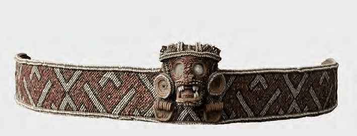
Ostapkowicz, on the other hand, brings a keen attention to detail and textual sources with a study of Taino material culture. In her thesis, a study of the Taino duho, Columbus is cited for Caonabo's explanation that every principal cacique of the island believed that after death, people go to a valley where they see their ancestors, eat, access their wives, and more. Caonabo explained that every cacique believed the valley of the afterlife was located somewhere in their own territory, perhaps implying that Coabay was not located in a single place.[41] In her recent study of cloth and fibrous materials, Ostapkowicz delves into an analysis of various items received in tribute from Caonabo's community in 1495. A combination of belts, masks with gold parts, naguas, hammocks, cotton, and sheets of gold were collected from Caonabo's Indians.[42] The presence of much material using cloth, though not as much as the cloth and textiles found in Anacaona's storehouse, indicates the degree to which cotton and textiles were part of the wealth of a cacique. As one of the most powerful caciques, and one whose name referred to gold, it is striking how so much of the tribute collected from Caonabo's subjects consisted of cloth. While gold was used with the masks and other objects given to the Spanish, one can detect a similar sense of value and wealth in Caonabo's Maguana as that of Xaragua. Given the close ties between Xaragua and Maguana, as well as the use of irrigation canals in both chiefdoms, perhaps cotton was one of the additional sources of wealth for Maguana. Alternatively, cotton may have been given in gift exchanges between Xaragua and Maguana, with the latter possibly serving as a source of gold. 

Conclusion

In summation, the mystery of Caonabo remains. For about 500 years, writers have disagreed on his origin. Keegan's theory of a possible origin in Middle Caicos is intriguing, but of course only a speculation. The "Carib" origin theory could still be true, but academics should explore the links between Hispaniola and the Lesser Antilles. For instance, the finding of Hispaniola-styled duhos at sites in the Lesser Antilles may be evidence of elite exchange or trade, perhaps pointing to a possible Kalinago origin of Caonabo through one of these networks. Moreover, questions remain on the domain of Maguana and how the chiefdom may have looked before 1492. In terms of the chiefdom's characteristics, the existence of irrigation canals or ditches as well as control of gold-producing areas likely made Maguana a populous center of attraction for much of Hispaniola. The alliance with Xaragua, another densely populated region with ample cotton production, likely included military dimensions that may have made Caonabo one of, if not the most, powerful caciques in Hispaniola. Finally, Caonabo's foreign origins and deft navigation of the political landscape of the island made him the best positioned to understand the threat posed by the Spanish.


[1]  M.L.E. Moreau de Saint-Méry, A topographical and political description of the Spanish part of Saint-Domingo: containing, general observations on the climate, population, and productions; on the character and manners of the inhabitants; with an account of the several branches of the government, Volume 1, 34.

[2] Pierre-François-Xavier de Charlevoix, Histoire de l'Isle espagnole ou de S. Domingue, Vol. 1, 81-82, 172.

[3] Carl Ortwin Sauer, The Early Spanish Main, 84.

[4] Émile Nau, Histoire des caciques d'Haïti, 116-117.

[6]  Alexander O. Exquemelin, The Buccaneers of America, 36.

[7] Thomas Madiou, Histoire d’Haiti, Tome VI, 356.

[8] Robert Schomburgk, “Ethnological Researches in Santo Domingo,” 91-92.

[9] Martha Ellen Davis, La otra ciencia: el vodu dominicano el vodú dominicano como religión y medicina populares, 138.

[10] Christopher Columbus in Ramón Pané, An Account of the Antiquities of the Indians, 45.

[11] Christopher Columbus, The Journal of Christopher Columbus (During His First Voyage), 141.

[12] Cristóbal Colón, Textos y documentos completos: Relaciones de viajes, cartas y memoriales, 243.

[13] Ibid., 256.

[14] Ibid., 277.

[15] Ibid., 324.

[16] Lynne Guitar, Cultural Genesis: Relationships among Indians, Africans, and Spaniards in rural. Hispaniola, first half of the sixteenth century, 121.

[17] Peter Martyr d’Anghiera, De Orbe Novo.

[19]  Bartolomé de Las Casas, Apologética historia sumaria.

[20] Jalil Sued-Badillo, Caribe taíno: Ensayos históricos sobre el siglo XVI, 19.

[23] Ibid., 584.

[24] Behique Dunama, “Interrogatorio de los Jeronimos.”

[25] Luis Arranz Márquez, Repartimientos y encomiendas en la Isla Española (El repartimiento de Alburquerque de 1514), 567.

[28] Samuel Wilson, Hispaniola: Caribbean Chiefdoms in the Age of Columbus, 86.

[29] Ibid., 91.

[30] E.W. Stone, “The Conquest of Española as a “Structure of Conjuncture,”’ 371.

[31] Gilbert R. Valmé, Atabey, Yucayequey, Caney : 6000 ans d'amenagement territorial prehispanique sur l'ile d'Ayiti / Haiti/ Republique Dominicaine, 15, 181.

[32] Bernardo Vega, Los Cacicazgos de la Hispaniola, 57.

[33] Roberto Cassá, Los Tainos de la Española, 222.

[34] Kathleen Deagan, En Bas Saline: A Taíno Town Before and After Columbus, 34.

[35] Jean Fouchard, Langue et littérature des aborigènes d'Ayti, 91.

[36] Ibid., 92.

[37] William F. Keegan, Taíno Indian Myth and Practice: The Arrival of the Stranger King, 35, 45.

[38] Ibid., 46-47.

[39] Behique Dunama, “Caonao (Cahonao).”

[40] William F. Keegan, Taíno Indian Myth and Practice: The Arrival of the Stranger King, 182.

[41] Joanna Ostapkowicz, Taino wooden sculpture: rulership and the visual arts in the 12–16th century Caribbean, 518.

Sunday, December 28, 2025

Caonabo's Hidden Treasure

 Although hardly reliable, the anonymous author of Observations météorologiques et physiques sur St.-Domingue. Description du Rio-del-Oro, ou Rivière d'Or de Christophe Colomb. Découverte des mines d'or par cet amiral. Renseignemens sur les trésors du cacique Caonabo. Origine des peuples d'Amérique. Description de leur berceau. Ages des deux mondes. Numéro 6 reported traditions of Caonabo's hidden treasure. According to his informants, Caonabo's treasure was thrown into a river by his wife (Anacaona?) since she heard gold was the god of the Spanish. This tale seems similar to what was later reported of Hatuey's actions in Cuba, so the historical accuracy of this is up for debate. Certainly in the 1495 tribute lists, golden objects from Caonabo or his community were rendered to the Spanish. But tradition in the 18th century had it that Caonabo's hidden treasure consisted of 300 plaques of gold, a throne (probably a duho), a golden table (table with gold-encrusted parts?) and 52 charges of gold bars. As a paramount cacique believed to control some of the gold-producing parts of the island, this is actually somewhat plausible. Indeed, locals believed the treasure was still somewhere at the bottom of the river...

Thursday, December 18, 2025

More on Indigenous Caribbean Historical Matches

As we should have done at the beginning, we finally went back and re-read the reference study (Fernandes et al.) used by 23andMe for their indigenous Caribbean references. As expected, our Matches are to Ceramic Age samples from sites in Hispaniola (mostly eastern), Puerto Rico, and Bahamas. Our historical matches fell into the following major groups based on the above study's analysis of the genomes of ancient Antillean peoples:

Haiti Ceramic: 2 matches

Bahamas Ceramic: 2 Matches

SECoast DR Ceramic: 11 Matches

Eastern Greater Antilles Ceramic: 11 matches

The overwhelming number of matches (although mostly small) are with what the study terms Southeast Coast DR groups and Eastern Greater Antilles (which includes samples from Puerto Rico and the eastern Dominican Republic). This matching pattern is to be expected given the Ceramic Age population largely replacing Archaic lineages and the pattern of close relatives from different sites on Hispaniola or genetic matches between individuals from other islands. To what extent this pattern was also due to relatively small population sizes in Hispaniola and Puerto Rico is another mystery. We have always tended to prefer somewhat higher population numbers for Puerto Rico and Hispaniola in pre-Columbian times based on Moscoso's analysis of Puerto Rico. 

We also found it cool that some of our larger matches were to the two Individuals in the Haiti Ceramic clade. These two individuals were related and harbored significant Archaic ancestry from groups on the island before the Saladoid or Arawakan expansion to the Greater Antilles (unless we are already outdated in our terminology here). We matched the two ancient Haitians from Diale for approximately the same amount of total shared cM on 2 segments. It would be interesting if part of that shared ancestry was from the earlier, Archaic population.

Tuesday, December 16, 2025

Indigenous Historical Matches

One of the more interesting aspects of 23andme is seeing the historical matches. Since we have ancestry from Puerto Rico that includes indigenous Caribbean admixture, we found a very large number of matches with the Indigenous Caribbean Ceramic Age samples on 23andme. While most were undoubtedly very small matches, we found it fascinating to see matches from the Haiti, Dominican Republic, Puerto Rico and the Bahamas. Indeed, some of the matches were with individuals buried in the same area, like the two from northern Haiti's Fort-Liberté Bay. To make the feature even more interesting, 23andme should provide more precise information on the chromosome segment's location. It might be worthwhile to explore these matches to various indigenous Caribbean peoples who were related to others from different parts of Hispaniola or even different islands altogether. 


Despite the lack of these features, it was still interesting to note that most of our matches are with samples from Hispaniola (mainly the Dominican Republic). This is presumably due to the far greater number of indigenous Caribbean samples from the DR as well as the migration/intermarriage of indigenous peoples between Hispaniola and Puerto Rico (and the Lucayan Islands). Nonetheless, we found it intriguing that the highest matches were with samples from Hispaniola. The largest amount of shared ancestry was with an ancient woman from the site of Andrés, east of Santo Domingo. Although we only share 16.45 cM across 3 segments with this woman, this supposedly means we share more ancestry with her than 99.90% of all 23andme customers who share DNA with her. The next largest matches were of 10.8 and 10.2 cM with two individuals from Diale 1, a site in northeastern Haiti. Although only 2 segments, the amount of shared DNA with the two individuals is similar and possibly the same segment. If 23andme provided the segment information, I could potentially explore my relation to the 2 people from the Diale site in Haiti and the woman from Andrés. Even more intriguing is the fact that the two individuals from Diale had 16-20% Archaic ancestry from peoples who lived in the Antilles before the Arawakan-speakers migrated to the Greater Antilles. Moreover, the two people from Diale, who lived sometime between 800 CE to 1200 CE, may have fallen under the sphere of influence of Marien, a cacicazgo that was perceived by the Spanish sources as the most powerful chiefdom or polity in northern Haiti. Of course, there is no evidence for Marien in this earlier time period, but the site which was the probable capital of Marien was inhabited by the 1200s.


In addition, we shared 2 segments of DNA with two other individuals from the modern Dominican Republic. In the case of Ceramic Age Caribbean Individual I15112, from El Atajadizo, DR, we have more common DNA with her than 91.90% of all 23andme customers. For Ceramic Age Caribbean Individual I12350, we share more DNA with her than 87.90% of all 23andme customers who match her. The general picture then is one of closer matches with women from sites in the DR and Haiti and a plethora of smaller matches in Puerto Rico, Dominican Republic, and the Bahamas. Since the site where these individuals were found is no sure guarantee of their origin, it is difficult to say with any certainty where they may have originated from. Therefore, it is possible some of these matches were with indigenous people who may have hailed from Puerto Rico or the eastern Dominican Republic before migrating. Nonetheless, we believe that the two related individuals from Diale, Haiti may have come from the area and one was male while the other female. Overall, the closest indigenous matches were from Atajadizo, a site near San Pedro de Macorix, and the two relatives from Haiti. The results could be explained by a number of factors but are certainly consistent with a shared ancestry between indigenous peoples in Puerto Rico and Hispaniola. They could also be due to the forced relocation of indigenous peoples from Hispaniola and the Bahamas to Puerto Rico in the 16th century. But historians and archaeologists have provided more than enough evidence for long-standing contacts between the eastern part of Hispaniola and Puerto Rico. 

Wednesday, December 3, 2025

Cacicazgo of Guahaba

Aubourg's map showing the placement of a village in Guahaba at the site of Lacorne.

Although often overlooked in colonial accounts, Guahaba was a major Taíno cacicazgo in northwestern Hispaniola, whose political importance and population size have been underestimated due to Spanish violence, depopulation, and incomplete documentation. Known as the land from which Hatuey fled to Cuba to escape Spanish invasion, Guahaba was located in northwestern Haiti. The exact boundaries of the district and its political organization before Spanish conquest is difficult to discern. Tejera, drawing on Las Casas and the Spanish chroniclers, described Guahaba as 18 leagues from Cuba (271). Guahaba itself was said to be in a valley with a river called Hami flowing in it (205). Bernardo Vega, also drawing on similar sources and Peter Martyr d'Anghiera, saw Guahaba as likely located between Gros Morne and Borgne, possibly also the area of Guanacano in the map of Morales (30). Moreover, the region Las Casas referred to as Araguey, a valley and river, was where the Spanish founded the town of Lares de Guahaba (37). Like Vega, Valmé also saw Guahaba as being centered in the valley of Trois Rivieres (178). Keegan likewise focused on Trois Rivieres as the probable location near Port-de-Paix of a very large Taino settlement seen by Columbus's men in the First Voyage (58). While scholars disagree on the exact details, it is clear that Guahaba was in Haiti's northwest, and perhaps with its largest settlement near Gros Morne or Port de Paix. Who was its paramount cacique is unclear, although Hatuey is a likely contender since he was able to lead a large following to Cuba.  

Arranz Márquez's table for the caciques of Lares de Guahava (Guahaba).

Unfortunately, looking at the 1514 repartimiento records sheds little additional light on Guahaba. The area had the smallest Indian population, only 487, but this was likely the result of 3 factors: the exodus to Cuba led by Hatuey, population loss incurred during the "pacification" of the area ordered by Ovando and probably the forced relocation of indigenous peoples to distant locations where mining was conducted or more profitable.  Of the 10 caciques with followers assigned to encomenderos at Lares de Guahaba, some still had indigenous names: Bayacaguera, Mayagumaca, Mota, Miquero. But the one with the largest number of followers, Gaspar Mejias, could have been from the old Guahaba elite or possibly one whose ascent was tied to the changes introduced by the encomienda system (Arranz Marquez 571). Judging by the small indigenous population assigned to encomenderos, one can only safely speculate that the Spanish conquest, encomienda system, disease, and flight to Cuba significantly lowered its population by c. 1514.

The Morales map of Hispaniola showing the northwest.

Even the excellent map of Morales, a great source for understanding, to some extent, the indigenous geography of our island, is of limited utility for Guahaba. Some places in northwestern Haiti are listed by their Spanish names, although some of the rivers and bodies of water retain indigenous toponyms. For example, Guanacano, south of Lares de Guahaba.The river "Hany" also appears on the map, flowing near Lares de Guahaba. Other places listed are too hard to read clearly, but the place at Haiti's northwestern tip appears to read Yahaba. Is this Guahaba? This region is certainly closer to Cuba than where Lares de Guahaba was founded, perhaps closer to the 18 leagues from Cuba mentioned previously. If so, the name must have been applied to a much larger area, extending to the east to Marien, the cacicazgo of Guacanagari. Yet the location of Lares de Guahaba and its proximity to rivers means this area could have been the population center of Guahaba in precolonial times. 

A dog figure found at the site excavated by Barker, possibly a capital of Guahaba (Olsen, On the Trail of the Arawaks). Olsen likens the figure to the dog cemi, Opiyel-Guarobiran.

If one looks to archaeology, only one settlement that was likely in Guahaba has been closely studied. Located on the old Lacorne habitation in Haiti, this site was known as early as 1947. In fact, Michel Aubourg, author of Haiti prehistorique, wrote that this was the site of 1000 huts described by Columbus when he first visited Haiti (54). This site was located 3 km from Trois Rivieres, south of the Tortuga Channel, and bordered on the east by Trois Rivieres. To its south lay the Lacorne habitation (27). Aubourg also believed it was a fishing village or settlement. Fred Olsen, in On the Trail of the Arawaks summarized the research of Paul Barker at the site. Many female figures were found there (Cadet site), and he believed it was the settlement of 1000 houses mentioned by Columbus. Some perhaps implausible figures are also suggested: 5-15,000 residents (114). Again, Columbus's problematic figures came from someone who did not see the settlement in question. Further, it was in his interest to portray the New World as agriculturally rich and full of people to justify the expenses. Still, it does appear that the Cadet site surveyed by Barker was large. Valmé, presumably drawing from Barker's work, described the site as including 240 houses (181). If this is accurate, this was definitely a very large settlement, possibly one of the largest in the Antilles. 

A narcotic grinder in the form of a frog from Guahaba (Olsen, On the Trail of the Arawaks).

As for the Spanish chroniclers and Columbus, they too are not detailed for Guahaba. Columbus, whose journal described northwestern Haiti, mentioned a group of Spaniards he sent to a large village in a valley 4.5 leagues southeast of the coast. This village, allegedly possessing over 1000 houses, was identified by the editor of the Markham edition and translation as modern Gros Morne (108). The people of this village also had hair over their shoulders and a river ran through the center of the valley. This does sound like modern Gros Morne, but further inland than the site at Cadet mentioned by Barker, which raises a number of questions. If the larger populated center was further inland, this would likely have been closer to where the Spanish later founded Lares de Guahaba. Columbus's son, whose The Life of the Admiral is also available in translation, described the same settlement. According to his biography, Columbus sent 9 men to this large inland village about 4 leagues from the coast, where they saw a village of more than 1000 huts in a valley (76). The details match those of Columbus's account, although now it is a little closer to the coast. 

Votive offering figure in the shape of a turtle's head from the Cadet site in Guahaba (Olsen, On the Trail of the Arawaks).

Besides Columbus and his son, the only other sources are the standard cronista accounts of the pacification of the island after Ovando's destruction of Xaragua. Rodrigo Mexia Trillo was sent north of Xaragua where he presumably clashed with Hatuey and other caciques in northern Haiti, ultimately defeating them and establishing Lares de Guahaba. Hatuey fled to Cuba and later resisted that island's conquest when Diego Velazquez arrived in 1511. According to Las Casas, about 50 years earlier Haitians had migrated to Cuba. Oliver has suggested this connection between eastern Cuba and Haiti can be seen in Taino complexes at Pueblo Viejo, Bani, Maisi, and Bayamo (161). It is thus more likely that migrations and cultural influence between peoples of Cuba and Haiti extended much further back in time. This contact must have facilitated the ability of Hatuey to establish himself in Maisi with his followers from Haiti. But besides passing references to Guahaba or Guahava in the campaign of Rodrigo Mexia Trillo and mention of Hatuey's flight to Cuba, little else is known.

Dog-shaped amulets in conch found by Barker in Haiti (On the Trail of the Arawaks).

Of course, one could not end the tale of Guahaba without following up on Hatuey's political career in Cuba. Established in Maisi, the heroic struggle of Hatuey was repeated by Las Casas. Las Casas, who may have deviated from historical truth to assign to Hatuey a special areito in which the god of the Christians was condemned (gold) and his epic refusal to become a Christian before his execution, is the best known source on this. However, whether or not this areito occurred or if Hatuey truly refused to go to heaven because Christians would be there, is not the point. Hatuey's resistance, which only lasted about 3 months in a guerrilla-styled conflict according to Mira Caballos, failed. But in a letter possibly from 1509 (or closer to 1511), Hatuey was described as "señoreaba la media Cuba" (330). To what extent this was hyperbole is also unclear, but Hatuey may have risen to a position of much greater authority than Maisi, easternmost Cuba. Indeed, his authority may have been more than that of a war-chief as speculated by Loven (504). This could have been reinforced by longstanding ties between eastern Cuba and Haiti with earlier alliances between caciques of the two islands that are not recorded in the Spanish sources. This may have made Hatuey an attractive figure for Cubans to support, particularly if he was a higher-ranking cacique in Guahaba before his flight from Haiti.

The monument to Hatuey in Baracoa, Cuba (Wikipedia)

Lamentably, his leadership did not coalesce into a larger anti-Spanish front. Yet despite his death by 1512, Hatuey's anti-Spanish movement was carried on by Caguax, who had served under him. Ultimately, the fate of Hatuey's followers is revealed only by 1514, in a letter by Velazquez. In his letter, he alluded to the Indians of "Yacahuey" or "Yahatuey" working for the Spaniards on estancias  near the Toha river. Some were even "free Christians" tied to the church of San Salvador. Indians still living in the region in the second half of the 16th century possibly include descendants of Hatuey's people. Lopez de Velasco mentioned "indios" living in Baracoa, Santiago, and Baracoa in the 1570s. To what extent Hatuey was remembered or the links to Guahaba is unanswerable, though Hatuey later became a symbol of Cuban nationalism and anti-colonial struggle.

In conclusion, Guahaba remains yet important chiefdom in the indigenous past of Haiti. The early sources that describe northwestern Haiti are often vague or difficult to correlate with the limited archaeological evidence. It is possible that Hatuey, the legendary cacique from Guahaba, was a paramount chief of the area before fleeing to Cuba. One of the largest known settlements in Haiti was also likely in the territory of Guahaba, though it is impossible to say this was the capital of the province. Similarly hard to answer is the relationship of Guahaba to Marien, its eastern neighbor. If Spanish sources describing Guacanagari as a paramount chief are accurate, Guahaba may have fallen under Marien's sphere of influence. Nonetheless, a very large settlement within Guahaba, possibly a fishing settlement, suggests it was a densely populated area. Guahaba's location in northwestern Haiti also made it ideal for exchange with Cuba and the Bahamas. This factor likely explains why Hatuey was able to lead followers to Cuba and find support from indigenous people there. In the future, archaeologists should revisit the Manigat and Cadet sites studied by Barker. Additional surveys in northwestern Haiti may reveal other sizable settlements in this part of the island.

Bibliography

Aubourg, Michel. Haiti prehistorique : mémoire sur les cultures precolombiennes, Ciboney et Taino. Port-au-Prince: Editions Panorama, 1966.

Arranz Márquez, Luis. Repartimientos y encomiendas en la isla Española: El Repartimiento de Albuquerque de 1514. Madrid: Ediciones Fundación García Arévalo, 1991.

Columbus, Christopher, and Clement Robert Markham. The Journal of Christopher Columbus: (during His First Voyage, 1492-93), and Documents Relating to the Voyages of John Cabot and Gaspar Corte Real. New York: B. Franklin, 1970.

Deagan, Kathleen A. En Bas Saline: A Taíno Town Before and After Columbus. Gainesville, FL: University of Florida Press, 2023.

Keegan, William F., and Florida Museum of Natural History. Taíno Indian Myth and Practice: The Arrival of the Stranger King. Gainesville: University Press of Florida, 2007.

Mira Caballos, Esteban. El indio antillano: repartimiento, encomienda y esclavitud (1492-1542). 1. ed. Sevilla: Múñoz Moya Editor, 1997.

Oliver, José R. 2009. Caciques and Cemí Idols : The Web Spun by Taíno Rulers between Hispaniola and Puerto Rico. Tuscaloosa: University of Alabama Press.

Olsen, Fred. On the Trail of the Arawaks. Norman: University of Oklahoma Press, 1974.

Tejera, Emiliano, Emilio Tejera, and Pedro Henríquez Ureña. Palabras Indígenas De La Isla De Santo Domingo. Ciudad Trujillo: Editora del Caribe, 1951.

Valmé, Gilbert R. Atabey, Yacayequey, Caney, 6000 Ans D'aménagement Territorial Préhispanique Sur L'île D'Ayiti: Haïti/République Dominicaine : Une Approche Holistique Du Patrimoine Zux Antilles : Les Paysages Culturels. Pompano Beach, Florida: Educa Vision, 2012.

Vega, Bernardo. Los Cacicazgos de la Hispaniola. 3. ed. Santo Domingo: Fundación Cultural Dominicana, 1990.